South Station / Dewey Square
Traces and Trends
In The Power of Place – Urban Landscapes as Public History, Dolores Hayden defines place as the perception of identity of a local urban environment. Its physical aspect involves a location, the presence of structures such as buildings and other aesthetic matters. Most importantly however, Hayden expands the definition of place by incorporating the “ways that urban history is embedded in the urban landscape”. She ties in urban history as a means of involving and understanding the community that is hosted by a place.
The past three essay's as part of this class project have striven for a factual analysis: of the site's present state, the effects natural processes and pre-inhabited state have had on its development and, in a larger context, its evolution throughout the past two centuries based off direct sources such as maps and photographs, respectively. This final essay will tie those more factual findings to their impact on the site's current appearance, to develop an identity of place as Hayden describes it. It should be noted that while Hayden emphasizes community involvement as an important part of unraveling this identity, that goes beyond the scope of this project.
South Station, Dewey Square and its surroundings have been a center of continues active change for the past two centuries. While this is true for any part of the urban landscape, the impact of major development projects has been more drastic on the site's appeareance then one would usually expect. Even though every generation has left its layer of construction on the entire area, what remains might not be more than a single building. Different aspects of the site's history surface in different locations, resulting in its physical appearance being a very fragmented mosaic of traces from different time periods.
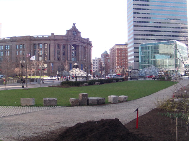
Dewey Square's fragmentation can be seen immediately on the following photo. Initially, it provides a good overview of the feeling this site has about it today. The sun is setting on a city running towards the end the working day: cars driving home, commuters walking to South Station, a by now empty grassy park area. A closer look at the picture reveals one of its more bizarre properties: every single building depicted originates from a different era or fulfills a very different property. The modern One Financial Center building in the center, constructed in 1983, stands right along the former Hotel Essex, which was built around the turn from the nineteenth to the twentieth century, replacing former stables and industrial buildings. Across the street from the former Hotel Essex stands what remains of the much larger 1899 construction of the South Station Railway Terminal, which presence and passengers made this an attractive location for the Hotel to settle in the first place. Further in the background, along Atlantic Avenue, some nineteenth-century industrial buildings remain. Most have been turned into residential blocks or office space by now. The picture's foreground displays the Dewey Square park, introduced during the big dig in the last decade. The open space in which this realization was made possible, is a trace carved in the urban landscape by highway development in the 1950s.
If one picture initially only depicting a site's current appearance holds references to so much of its history, then how can a single essay like this one capture all there is to say about traces and trends to be found in this particular location? The only obvious answer is that it can not, not even for an area no larger then a few city blocks. It can however, investigate a few details and the stories they tell.
An Industrial Past
Old maps from the Dewey Square area indicate its primary function was industrial. This was the case throughout the entire nineteenth century, where supplies were brought in first over water through the wharves, and later through the railroad coming in from the east. Alongside distilleries, furniture factories and cotton warehouses the neighborhood hosted the dominant leather industry, to which it still owes its name. Initially I had a lot of trouble identifying remnants of those functions today, but after seeing several old industrial buildings on our class site in Cambridge it became clear that very often these buildings have been altered effectively to accommodate their new functionality.
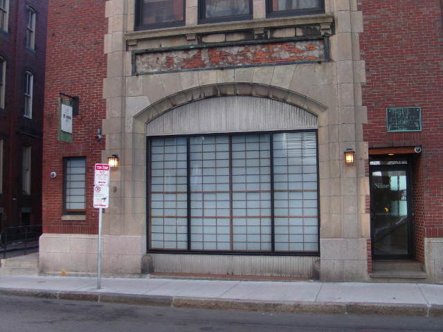
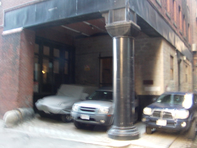
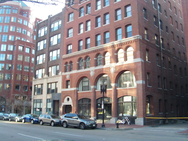
This is definitely the case in the Leather District. In the four blocks south of Essex Street, most buildings have not yet been demolished to make room for skyscrapers or highways, and their industrial past is revealed in details such as their facade structure, or their construction around the back alleys. One building along Atlantic Avenue repurposed an old truck loading bay as parking area for cars. Large openings that provided access to the warehouses inside have consistently been reused as windows for shops on the ground floor, or closed altogether.
Interestingly enough, these few remaining industrial buildings currently know very different uses from the new office towers at most one block away. While some of them definitely serve as office space, a lot of them also fulfill a residential function. The ground floor levels then, are often used for commercial activities such as retail, restaurants or coffee shops (e.g. Dunkin' Donuts, on the corner of East Street and Atlantic Avenue). One of the buildings even hosts a real estate office on the ground level, in what seems to be an opening previously part of the building's function as a warehouse, not too surprisingly specializing in converted residential lofts. One sign on a building in East Street still reveals its previous industrial function: Boston Hide and Leather Co. Inc.
Open Space: Trace of a Recent Past
Another important property of Dewey Square today that is easily taken for granted is its large, green open space. Yet in an urban environment like Boston, a section of land that was part of the original settlement that is now completely empty is everything but obvious. In this case, it is a trace of the highway development of the 1950s, when the John F. Fitzgerald Expressway, a stretch of elevated highway though downtown Boston named the Central Artery was erected. As part of this project, all buildings between Purchase Street and Atlantic Avenue were cleared (as were many more in its path throughout the Boston city center). As part of the Big Dig project, the area was then recently cleaned up and converted into a park. This development symbolizes one of the many ways in which our opinion on how space should be assigned changes over time. An initially mainly commercial area was cleared and reallocated to its transportation function as a highway, and later repurposed to an open park.
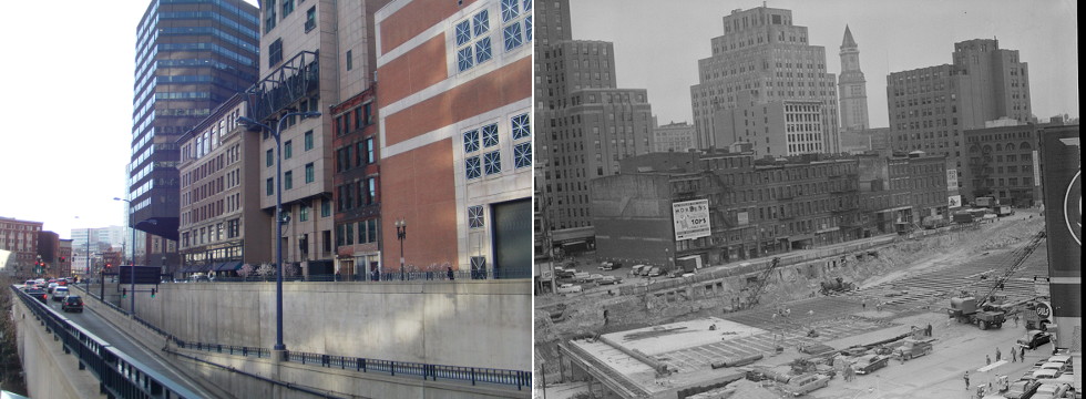 The same row of buildings along Purchase St, today and during the Central Artery Construction. One building remains. (Leslie Jones, Boston Public Library)
It should come as no surprise that this highway development was such an overhauling factor in the identity of South Station as a place. As Hayden mentions when wrapping up her definition of space, it “becomes more difficult to analyze the experience [freeways] provide in terms of human perception and memory, but easier to track the production of that American automotive space as the world's largest and most grandiose public works project.”
In the aftermath of the introduction of the Central Artery, the area transformed into a vibrant part of Boston's financial district. This brought with it the introduction of several office towers. Today, only one run-down, misplaced building constructed before 1950 awkwardly remains as an artifact of earlier times. All its earlier neighbors have made room for the Fiduciary Trust Building, a building that belongs to the MBTA and what seems to be an enormous power supply building. Next to its impact around it, the highway that carved through this site fulfilled an important transportation function during its existence, which brings us to the next observation.
Layers of Transportation
Throughout the essays in this semester-long project, transportation has been a recurring theme. Perhaps it has been more recurring then I initially intended it to be. I have tried to include the socio-economic development of the area at all times, yet transportation is so dominant around South Station that it is impossible to ignore. The picture below, again a simple view taken from the sidewalk, reveals a history of South Station's changing history of transportation of over a century. The picture's foreground is dominated by the asphalt and cars that have taken over Atlantic Avenue since the 1950's. In earlier times it supported the Atlantic Avenue Elevated Railway, and mostly pedestrians and horse-driven carriages. Central on the photograph is the main entrance to the South Station Railway Terminal, whose decline and resurrection throughout the past century has been discussed earlier. The entrance to the Red Line of Boston's subway system can be seen in the modern, glass and steel construction building in the background.
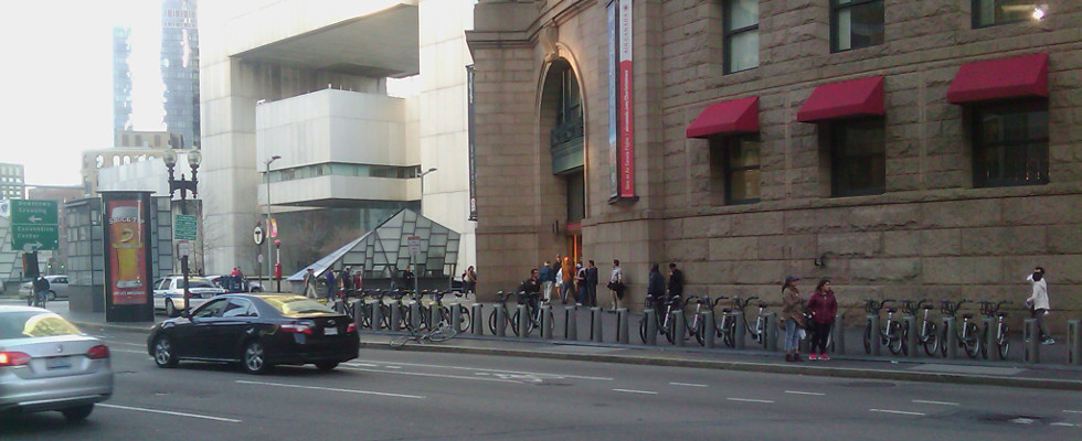 4 Layers of transportation: road, train, subway, hubway
Dolores Hayden makes an extremely interesting statement when talking about these large transportation-related development project. “All of these different kinds of private and public planning activities and public works have a social as well as a technological history. People fight for and against them. People also construct and maintain them.” I've gotten a chance to explore the technological history of these developments, and the social history to the extent of their impact on the surroundings (i.e. changing industries, land use, …) Constructing South Station, the central artery or the Greenway must have attracted large crowds of workers that are undeniably part of the identity if place to be found at South Station, especially in times when workers could not yet commute to a construction site, while I did not get to explore that aspect.
The photograph above still holds one significant detail that can hint at a bridge from the past, through the present to the future of transportation. The bike docking stations in front of South Station are part of the Hubway bike sharing system which was only introduced in July 2011. I believe this to be an indicator of a developing trend in our cities: the automobile, which has for decades been considered the untouchable “final solution” of transportation in the urban environment, now has to make way for alternatives. These bikes don't necessarily cause commuters to choose alternative methods of transportation over automobiles, I would argue that the mentality changes in our society and urban planning decisions in urban renewal support their existence. The presence of the Hubway bike sharing system demonstrates that it has become enjoyable to bike along the Greenway, that is has become possible to bike through Boston's downtown as cars have been pushed into narrower lanes to make room for bike paths.
Questions about the future
The urban environment has now been proven to be in continuous development. That means it can in no way remain in its current state. It will involve, that we know for sure, but how exactly it will develop will always remain a question only time itself can answer. Based off what has happened so far, it is possible to make predictions. We might be able to expect urban development to continue repositioning the automobile to become a more habitable and enjoyable city. The re-expanding passenger railway service to South Station might bring in more commerce. There is also no reason for certain functions currently established in the neighborhood to remain there per se – one could imagine businesses moving out into the suburbs much in the same way residents and industry did years ago. Although useful, predictions will never be able to provide a conclusive answer. When even single investments in the past have drastically changed the way a site functions, it is impossible to exactly predict how that site might develop. That statement still applies and becomes more important the other way around: predictions like these are especially important for deciding what investments to make, aiming to improve the overall quality of living in the city – both from a private and public perspective.
A last layered photo I would like the consider is the following. This is the site I have been describing in these four essays viewed from outside, across the Fort Point Channel. This water has always been here, as described in the second essay on Natural Processes, and initially brought the supply of goods that made the industry in the area prosper. Right underneath the sun is South Station, now accompanied by the One Financial Center building, the Federal Reserve Building, and a newer office building built in favor of parts of the then-bankrupt railway terminal. This skyline itself, from this exact point of view, has evolved, layer after layer, over the last three centuries – starting from an empty peninsula and water, to a harbor, to an industrial rail yard, to today.
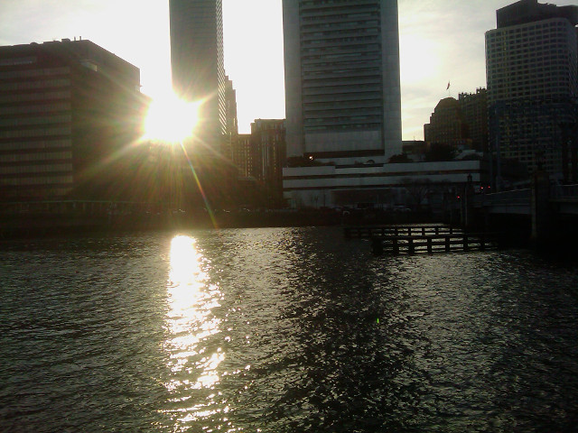
The sun setting over South Station here also accompanies the end of this series of assignments. Yet tomorrow it rises again. This is why I believe it's important to understand the processes that shape and define the urban landscape: let us make sure that tomorrow's decisions don't resemble yesterday's mistakes.