|
|
|
QUICK
LINKS |
|
-- Sea
Morphology Changes and Sensor Placement
|
|
-- Team 5 Home -- Mission 2009 -- MIT |
|
|
Sea
Morphology and
Sensor Placement Proposal
Definition
Sea Morphology: the branch of geology
that studies the characteristics and configuration and evolution of
rocks and land forms.
Sea Morphology
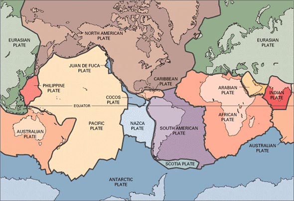
Tectonic plates cause
many different
natural disasters that occur on our planet. When the plates move,
they tend to create stress between them. This stress, once built up
can be relieved in one catastrophic event
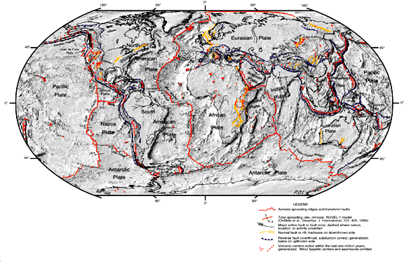
that changes the face of the globe. Some of this can be seen in this
picture of the World. The main subduction zones are clearly seen
in this photo. Around where the December 26 Tsunami happened,
there is a light blue outline and there is a ridge there that was
caused by this last earthquake.
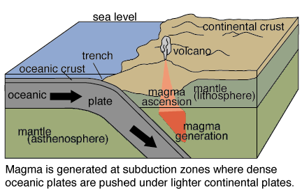
Here is a diagram of what the a subduction zone looks like. As you can see, the plate tends to go under another plate. There are three types of plate-plate interactions based upon relative motion: convergent, where plates collide, divergent, where plates separate, and transform motion, where plates simply slide past each other.
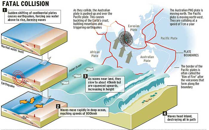
This depics what happened on December 26 2005. It shows how the when the continential shelf shifted in the earthquake, it droped the sae floor and created a wave. It shows how as the wave gets closer and closer to lane, it begins to pick up its speed and its height begins to rise based on the magnitude of the force.
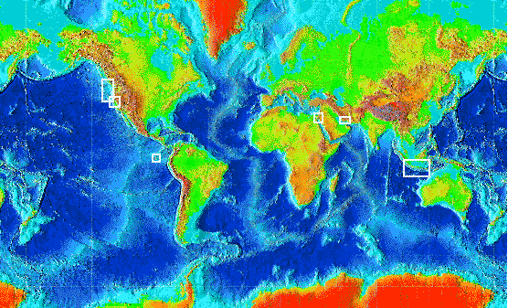
A question we needed to ask was how
many buoys we need to put at each location. We propose to put 1 buoy
around the area of Peru and 3 around the area of Micronesia. The
buoy location is represented by the little thumbtack in the picture
below.

The
reasons for these choices are due
to the fact that the way the continental slope moves and also the
efficient depth for the operation of the buoys. The diagram below
depicts the differences between the continental shelf and the
continental slope. The buoy would sit on the ocean floor and here it
would measure the changes in depth and pressure in the water. (2)

The continental slope moves around a great deal. Anything that is put on there will most likely go under and will be useless. The diagram below shows some of the movement that can occur in the area of the continental slope. The continental shelf would be a nice place to put it but it is too shallow to put it there. If it is there you also run into the possibility of fisherman accidentally fishing up the BPR, and running into the Buoy.

This
picture shows what is happening
around the area of Peru the Nazca plate is going under the South
American plate and that is what can cause earthquakes under the
ocean.

Proposal for
Micronesia
The points that were selected around Micronesia are locates on the map below. In the area of Micronesia we are proposing three buoys. The buoys will be in locations surrounding the northwestern to the south part of the islands. The positions of the buoys in the vicinity of Micronesia would be about 1 degree north and 161 degrees east, 11 degrees north and 152 degrees east, and 4 degrees north and 141 degrees east. These locations are prime because they surround the island in the areas that are most prone to have earthquakes. (5) Another thing we considered is the locations that the tectonic plates and how they are moving in relation with this area. Around that area there is a spot where four tectonic plates collide, and that was one of our prime spots to be on the look out for. (11)

The locations were decided upon data that was collected from maps and professors. The maps were both topographic and tectonic. We also used historical evidence from these to predict where would be the most area prone to tsunamis based on the locations and magnitudes of earthquakes.
Sources
1) Google Earth-Maps
2) Professor David Mohrig, Dept. of Earth, Atmospheric and Planetary Sciences.
3) Descriptive Model of the July 17, 1998 Papua New Guinea Tsunami Related Publications
4) Ashkenazi, I., and J. Shemer. "Tsunami--the Death Waves." Harefuah 144.3 (2005): 154,9, 232
5) The rock islands, Palau, Micronesia.(2003). Geographical, 75(11), 106.
6) Tsunami Scattering and Earthquake faults ib the Deep Pacific Ocean, Harold O. Mofjeld, NOAA, Pacific Marine Environmental Laboratory, Christina Massell Symons, Peter Lonsdale, Scripps Institution of Oceanography, Frank I. González, Vasily V. TitovNOAA, Pacific Marine Environmental Laboratory. Oceanography Vol. 7, No 1/2004
6) "A Lesson in Plate Tectonics." Extreme Science 2005 http://www.extremescience.com/PlateTectonicsmap.htm
7) Scaillet, B., and G. Prouteau. "Oceanic Slab Melting and Mantle Metasomatism." Science progress 84.Pt 4 (2001): 335-54
8) New Model for the Structure of the Ocean Crust. J. R. CANN. Nature 226(06 Jun 1970), 928-930 (06 Jun 1970) Letters to Editor.
9) Initial Report on 23 June 2001 Arequipa, Peru Earthquake. http://www.eeri.org/lfe/pdf/peru_arequipa_initial_reconnaissance_part1.pdf
10) Dr. Steve Gao. http://earth.geol.ksu.edu/sgao/g100/plots/.
11) Baldwin, S. L., et al. "Pliocene Eclogite Exhumation at Plate Tectonic Rates in Eastern Papua New Guinea." Nature 431.7006 (2004): 263-7.
12) Tsunami : The Underrated Hazard. New York: Cambridge University Press, 2001.
Graphic
for banner on this page from http://www.noaa.gov/tsunamis.html
![]()
Page
last updated by levont at 11/2/2005 2:43:16 PM
Timestamp