Background
Sources are cited by numbers. The
numbers refer to categories in our References list.
What is a levee?
A levee is a mound of earth or some
artificial material, such as concrete, that is built up along a
boundary with
some body of water to keep the river or lake from overflowing onto what
the
levee is protecting behind it.
(10)
What are some
types of levee
reinforcements?
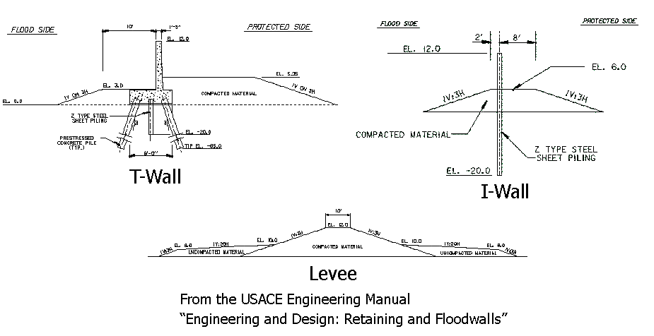
A levee can have some special
reinforcements, such as I-walls, T-walls, and aprons. I-walls are
basically
walls built into the ground around which the levee is built up. T-walls
are
basically the same, but they have a weighted, wider base; thus, they
are
somewhat more stable. Aprons are coverings that are put on top of the
levees to
help prevent erosion. They can either be artificial, like concrete, or
natural,
such as a pile of rocks. They are especially useful to prevent erosion
on the
backside of the levee in the case that overtopping occurs.
(10)
What is the
history of the Mississippi River
levee system?
The Mississippi
River levees have been built in stages since the 1700s. At
first
farmers built them to protect their own farm land from being flooded
along the Mississippi River. Then the
government started getting
involved in the construction and maintenance of the levees when the
port city
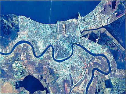
of New Orleans
became increasingly important to the nation’s economic health. The
canals were
built into the system in 1878 to drain water from the city. The primary
function of the levees was to protect from flooding from the Mississippi River, not from a hurricane. More
recently, the focus has shifted
to hurricane protection.
(3)
What is the
effect of subsidence on
the levee system?
But New Orleans
has become too dependent on its levee and pumping systems because New Orleans
itself is
sinking. Much of it is already well below sea level. The city was built
on
wetlands that have been pumped dry and over a fault that is gradually
swallowing up land. Consequently, levee failures are even more
catastrophic
because the water will just sit in the city. Subsidence also causes the
levees
to sink, thus decreasing the effective height of the levees.
(10, 11)
What have been
the effects of past
floods
on the levee system?
In 1927, the Mississippi
was flooding so the people of New Orleans
destroyed some of the upstream levees to save the city before the flood
reached New Orleans. After Hurricane Betsy in 1965 the Army Corps
of Engineers rebuilt the levee system by constructing I-walls, which
are the
cheapest and least stable form of protection. That was the last time
the New Orleans
levee system
was seriously updated.
(3)
What was the
state of the Mississippi River levee
system pre-Katrina?
A map of this is shown in the maps
section of the webpage. The levee system was supposedly built for a
Category 3
hurricane. Levees are present on either side of the Mississippi River
to
prevent flooding from its rising river bed, and levees are present
along Lake
Pontchartrain, the Industrial
Canal, and
the
Mississippi River Gulf Outlet to prevent flooding from rising water and
storm
surges from hurricanes. An ample Hurricane Protection System was
proposed in
1992 and construction had begun on it, but by the time of Hurricane
Katrina
only 45% of it was completed.
(3)
Where
were the levee breaches
caused by Hurricane Katrina and what caused them?
17th Street Canal
and London
Avenue Canal
Breaches:
At one point along the 17th Street
Canal Breach and at two points along the London Avenue
Canal, the
levees were
not overtopped but failed. The levees in this area
are about 14 feet, but the water inside the
canals was only at 8.5 feet. The canals were backed up with water from
the
storm surge coming from Lake Pontchartrain.
The pumps in the canals were unable to pump the water out because the
pumps
were located below sea level in the section of the canal in the
interior of the
city, not near the lake. The levees along both canals are concrete
I-walls atop
earthen levees. The concrete walls were actually pushed aside by the
water
pressure building up inside the canals. The steel pilings driven into
the soil were
too shallow, and the soil foundations in which the concrete walls were
anchored
in were poor, too soft, and permeable. Water was able to seep through
and
undermine the foundations and wedge the wall from its foundations,
causing the
whole wall to be pushed over and water to enter the city. The canals,
which are
supposed to pump water out of the city actually caused much of New Orleans to
flood by
letting water into the city. The breaches at the 17th St. Canal and London Avenue Canal
were caused by
engineering failures. The levees were built of poor soil, the pilings
were not
deep enough, and the pumping system was designed poorly.
Funnel
Effect, Industrial Canal
Breach, and Flooding in St. Bernard Parish and New Orleans East:
A storm surge many feet higher than
predicted for a Category 3 storm preceded Hurricane Katrina into New Orleans. It
came down
the Mississippi River Gulf Outlet (MR-GO). It then entered the Intracoastal Waterway. While in the MR-GO and Intracoastal Waterway, the storm surge
overtopped the
earthen levees along St. Bernard Parish to the south and New Orleans
East to
the north. The overtopping of the levees caused erosion on the backside
of the
earthen levees as water came spilling over, weakening the system even
more. The Intracoastal funneled the
storm surge into the Industrial
Canal where it met up
with storm surge coming in from Lake Pontchartrain.
The levees
with concrete
floodwalls on the Industrial
Canal were
breached once
on the west side into Bywater and twice on the east side into the Ninth
Ward,
where some of the worst flooding occurred. All of the levees in this
area were
overtopped. The water was 1.7 feet above the 13-foot levee. The
overtopping
eroded the levee on the protected side, letting more water pour in.
However,
some evidence shows that the initial flooding of the Ninth Ward
occurred before
the levees were overtopped. The levee was built on top of marsh which
was on
top of clay which in turn was on top of sand. However, the sand was at
a depth
too great to affect the integrity of the levee. A gap, or wedge, formed
on the
canal side of the levee between the wall and the marsh foundation
increased the
water pressure on the wall and probably caused it to fall over and
flood the
Ninth Ward.
Many of the levee breaches occurred
where two different types of levees were joined together. At these
joints of
the two kinds of materials the weaker one would fail. This is why
standardization
of levees will be key in the solution. Different groups built on top of
each
other’s work at different times causing discontinuities in the system.
(4)