Sources
are cited by numbers. The numbers refer to categories in our References
list.
Introduction
Team
4 greatly recognizes and emphasizes the need for the conservation and
restoration of the wetlands. We could implement all our solutions and
build all
our structures, but they would be almost useless without the natural
barriers,
such as the wetlands and coastal islands. They serve as the first
buffer from
storm surges and as a major drainage outlet, not to mention their many
other
ecological benefits, such as water treatment. We encourage you to also
look at Team 3’s
website
for more information on our class’s plan for the restoration and
conservation
of the wetlands. The wetlands are essential to the short and long-term
survival
of New Orleans.
We
also face a two-fold problem with water encroaching on New Orleans from
two sides. The Mississippi
is rising in
its banks on one side of the city, while the seasonal threat from
powerful
hurricanes makes us keep a worried eye on the ocean. Both have the
potential to
flood New Orleans.
Our plan represented below deals mainly with the threat of a flood from
a
hurricane, but it also includes some features to protect against a
flood on the Mississippi.
For our class’s more comprehensive plan for dealing with the rising
Mississippi
River and subsidence in New Orleans look at Team
9’s website.
Many
challenging factors had to be taken into account for our plan. As
mentioned
above, the loss of the wetlands over the years and the rising
Mississippi River
are two of the biggest threats, but subsidence and the fact that much
of New Orleans
is already
below sea level also affected our solution. Our figures also had to be
readjusted to account for global warming. In the future, global warming
will
cause sea levels to rise, which means more land loss and a rising water
line,
and it will also cause increasingly powerful hurricanes from the Atlantic, which means more powerful storm surges
and
flood waters. We also looked at the possible environmental effects of
our plan
because we didn’t want to greatly imbalance any ecosystem.
Many
of the levee failures, which we looked at in detail in our Background
section,
were human error and bad engineering design, which can be fixed by
careful
design, construction, and maintenance. The New Orleans flood protection system
was not
built cohesively as one uniform system. It was built in phases and
stages by
many different groups. We emphasize the importance of standardizing the
construction, monitoring, and maintenance of the system.
The
above was just to give you a little insight into our thought process as
we
researched and formulated our solution. Our plan, presented below, is
designed
to preserve and protect New
Orleans
from future floods in the long-term.
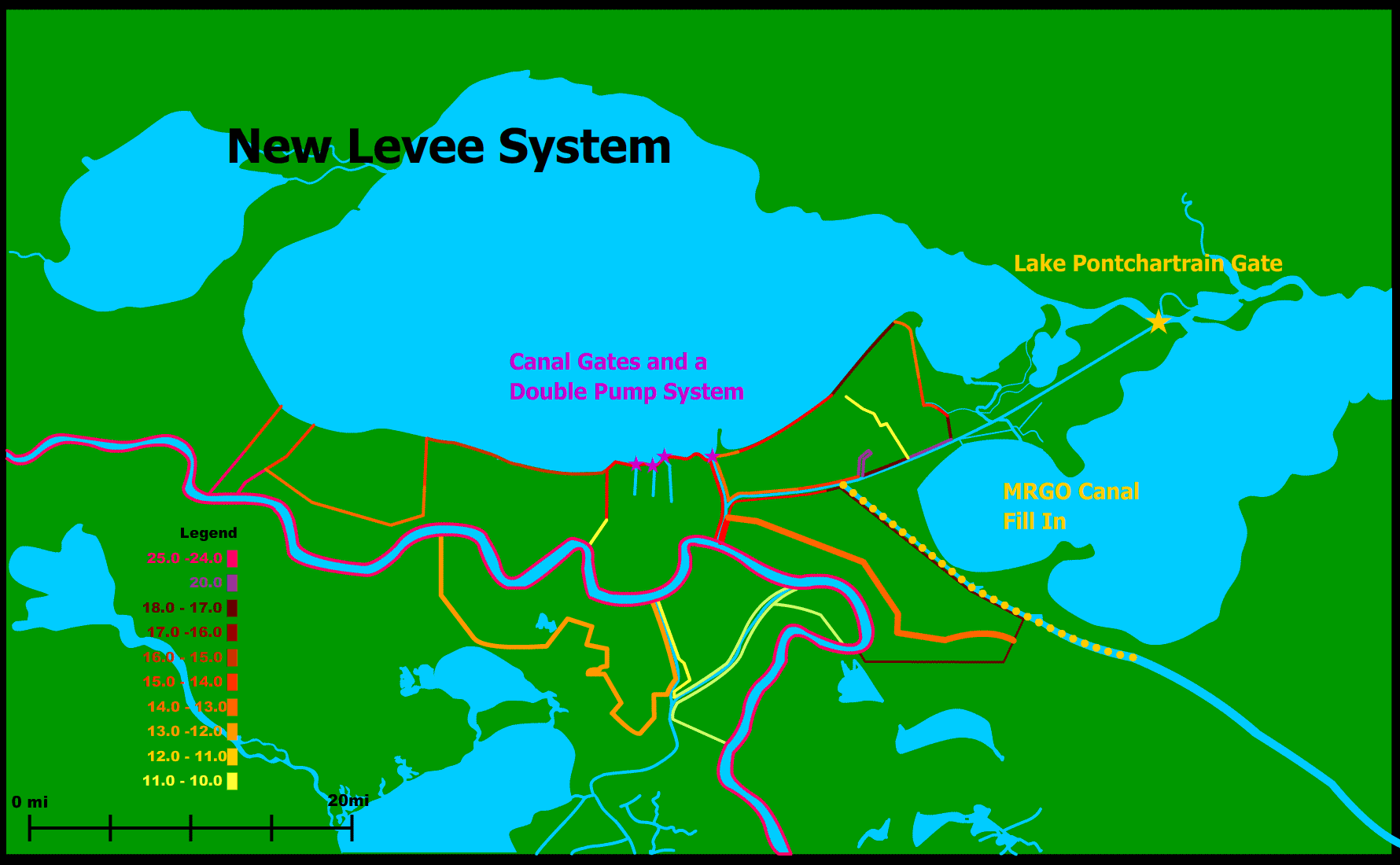
Barrier Across
Opening to Lake Pontchartrain
By the
time Hurricane
Katrina had reached New
Orleans,
it had shrunken to a category 3 hurricane. One main reason for why the
damage
was so catastrophic was because Lake Pontchartrain
was rising rapidly due to surges that were caused by Katrina when it
was still
a category 5 hurricane.
In addition
the Lower Ninth
Ward was flooded in part due to surges coming down the Intracoastal
Waterway
connecting the Mississippi River to the entrance to Lake Pontchartrain.
We propose
solving both of
these problems by installing large sluice gates across the opening to
Lake
Pontchartrain just before the opening to the Intracoastal Waterway (see
map for
exact location). These gates will be modeled after a similar sluice
gate (the
Weerd's sluice gate) currently in use in Utrecht, Netherlands
to
help protect their delta. The sluice gates should protect the
Intracoastal
Waterway, the canal gates, and the levees along Lake
Pontchartrain from storm surges.
Sluice gates
are moveable
gates.
Metal plates slide vertically into grooves in the sides of the
structure. The
operation of our gate would be controlled by a hydraulic mechanism.
This solution has actually
been proposed
in the past but was shot down by environmental groups. They feared the
negative
environmental impacts on the Lake and
the
necessity of the tides in the lake everyday to flush out the sewage.
However,
the gate would only be closed in times of emergency when rising waters
in Lake Pontchartrain and threatening
storm surges were an
issue. At most we predict this to be about a week per year during the
hurricane
season, so the environmental effects on the Lake
would be minimal.
The shipping industry will
still be able
to use the Lake as usual, except for
the short
periods of time when the gates will be closed due to threats. The
amount of
safety and security from storm surges provided by these gates would
greatly
outweigh any economic loss.
The Governance of the Gate
would be given
to NOAA (National Oceanic and Atmospheric Administration). This federal
agency
is in charge of providing
“data and forecasts for weather and water cycle events,
including storms, droughts and floods” (NOAA). The agency would watch
the
weather forecasts for the Gulf Region and alert the city of New Orleans when a threatening storm surges or
water levels would be
present in Lake Pontchartrain. The
gates would
be closed and remain closed until the water levels subsided.
An important
first step must be taken before we build the sluice gate is to
rehabilitate the
land on either side of the opening to Lake
Pontchartrain. The land has
been eroded by rising
sea
levels and storm so more land needs to be brought in; however, the main
problem
is the quality of the soil there presently. It needs to be replaced
with soil
of better quality.
(7, 15)
NOAA
Public Affairs. (2006 Nov 2) About NOAA. Retrieved November 18, 2006
from http://www.noaa.gov/.
Closing
off the
Mississippi River Gulf
Outlet
Team
8/9 is planning to create two main distributaries leading to the east
and west
of the current channel of the Mississippi River. These
distributaries would deposit sediment in the surrounding wetlands to
help
revitalize them. The eastern distributary channel will utilize
the
current Mississippi River Gulf Outlet (MR-GO). This channel was
filled in
with an average of about 15 ft of silt by hurricane Katrina and is
accessible
only by small, shallow draft vessels until dredged. Rather than
spending
extra money to dredge this channel, it should be filled in from its
intersection with the Intracoastal Waterway until the southern tip of Lake Borgne.
The funnel effect during Hurricane Katrina that flooded much of New
Orleans
East and St. Bernard Parish and ultimately caused levee breaches
along the Industrial
Canal
initially came up through MR-GO. Closing
of MR-GO end the funnel effect that worsened the storm surge from
hurricane
Katrina. A distributary from the Mississippi river
should be directed into the remaining lower section of the MR-GO.
This
distributary will redirect a maximum ¼ of the river’s volume, or
about 103,000
ft3 of water during normal water levels. The
intersection of
the previous MR-GO channel and the new distributary will be marked by a
flood
gate that will control the amount of water allowed to enter the
channel.
This way, during periods of low water, more of the river’s volume can
be kept
in the main channel to ensure a navigable channel for ships.
The
impact on the industry and shipping of New Orleans should not be very great.
Usually the MR-GO is
used by commercial ship as a short cut from the ocean to the port of New Orleans,
but closing it off will only add about 40 miles to their journey. The
security
from preventing another funnel effect by closing off the MR-GO greatly
outweighs the frustration caused to any industry.
(15)
Some of
above text
courtesy of Team 9 website
Brown, Matthew. (2005).
Corps suspends
plans to dredge MRGO. [Online]. The Times Picayune.
http://www.nola.com/newslogs/breakingtp/index.ssf?/mtlogs/nola_Times-Picayune/archives/2005_11_21.html.
Mississippi National
River and Recreation Area.
[Online]. General
Information about the Mississippi River.
http://www.nps.gov/archive/miss/features/factoids/.
Canal Gates and Double Pumps
Unfortunately
the very same
canals that have successfully drained New Orleans for many years were the
reason for much of the
flooding in Northern parts of the city. The pumps also were useless
because
they were unable to pump water out because they were situated in the
city below
sea level. As a result, the levees along the canals failed and the
water was
free to flood the city.
To solve
this problem we
propose installing strong gates at the front of the 7th Street, London
Avenue, and New Orleans Avenue Canals. They would basically be single
sluice
gates that slide vertically. This has actually already been implemented
in New Orleans.
Temporary
gates are in place already with plans to put in permanent ones. These
gates
will remain open most of the time to allow the canals to serve their
usual
function of draining the city, but when there is the threat of a storm
surge,
the gates would be closed to prevent water from pouring into the canals
and
putting pressure on the floodwalls and levees.
The same
system that will
control the opening and closing of the sluice gates on Lake Pontchartrain will control the canal gates.
There is
currently work in New Orleans
to rebuild the
pumping stations and increase their capacity. The pumps are designed to
drain
the city of water. They were not built to operate during hurricanes. To
fix
this problem we propose implementing a double pump system, in which
pumping
stations are present at both the lake shore and in the interior of the
city
where the canal ends. This would increase the pumping capacity and
redesign the
city so that it could handle both normal drainage and hurricane floods.
(4,15)
Levee
Re-Construction
The engineering failures
and inadequate
heights of the levees were major factors that caused the flooding of
the city.
The levee system in the New
Orleans
area includes about 450 miles of levee. The map above shows the heights
to
which we plan to build the levees or maintain them. We plan to rebuild
all of
the pre-Katrina levees at heights adequate to withstand storm surges
from a
Category 5 hurricane. We are also lengthening the levee in Jefferson
Parish so
that it extends all the way to the west to the Mississippi
River.
Among our improvements are
replacing all
I-walls with T-walls. I-walls in many place including in the 17th Street
Canal and London
Avenue Canal
levees and along the Ninth Ward. T-walls are a much more structurally
sound.
They are less likely to be pushed over because of the wider, heavier
foundation. Floodwalls are rated according to a factor of safety. They
should
have a factor of safety of 1.3, meaning that they are 33% stronger than
they
need to be to deal with the water pressure. However, it was found that
17th
Street Canal had only a factor of safety of 1, so there was little
question
that they would fail.
To protect against
subsidence, we have our
maintenance and monitoring program that will be described later. We
will also
look at the subsidence rates at each individual levee site on a small
scale.
Part of the previous problem was that the Army Corps took the average
of the
subsidence rate along very long lengths of levees. This system puts the
whole
levee in danger because it disregards very extreme, dangerous
subsidence rates.
From now on, however, subsidence rates will be dealt with on an
individual
basis, instead of averages.
Poor soil quality was
another huge issue.
The 17th Street
Canal levees were built on top of sand that caused the foundations to
be
unstable. Also, many of the floodwalls were anchored in soft clay,
allowing
rising water to push the wall horizontally and a gap to form at the
base of the
floodwall. If the quality of the soil is poor at the locations of the
levees,
we will replace it with suitable soil. Although this is an expensive
solution,
it is the only way to ensure the stability of the levees and
floodwalls.
Extensive evaluation of the geology of the levee locations is
essential.
To protect against erosion
from the levees
along the 17th
Street, Orleans
Avenue, and London Avenue Canals
and the Industrial
Canal
will be armored with concrete on the backside so that overtopping will
not
erode the backside of the levee and cause a levee failure. They will
also be
armored on the water-side of the levee at the base of floodwalls so
that gaps
can’t form at the between the base of the floodwalls and the soil.
(4,10,15)
Levee
Maintenaince and Monitor Boards
This is a supplemental
method of
implementation that we have proposed to ensure that our proposals will
be
correctly implemented. To read more about this click here.
Long
Term
Our long
term plan is
mainly one of vigilance and adaptation to new problems as they arise.
In the
past, the levees were built and were not taken care of; thus, they
degraded and
were not adequate to deal with Katrina. The most long-term part of our
plan is
our maintenance and monitoring program and our plan for governance of
the
levees explained above. Maintaining the levees religiously will provide
a large
amount of protection from future floods. Also, the Levee Governance
Board is a
flexible, powerful body that will be able to institute changes to the
flood
protection system if unforeseen challenges or problems come up.
Cost
We have divided
our costs into 6 major categories. As we
mentioned, in our Army Corps section, we plan on contracting the work
out to
private contractors, using a mainly local workforce.
Improvement/Repair
|
Cost
|
Sluice Gates Across Lake Pontchartrain
|
$2.035 billion (Swenson Times-Picayune)
|
Closing of MR-GO
|
$1.47 billion (Dredged Material)
|
Levee Repair and Construction
|
$9.425 billion (Wagner)
|
Interim and Permanent Gates on 17th St.,
London Ave, and Orleans Avenue Canals
|
$0.350 billion (Wagner)
|
Monitoring by Differential Global Positioning
System
|
$1.5 billion (Wagner)
|
Pumping Stations
|
$0.345 billion (Wagner)
|
Total:
|
$15.125
billion
|
Application to Other Areas
Other
areas may be
interested in using our idea of moveable gates to control water flow,
either on
canals or on larger bodies of water. Sluice gates are an effective
method of
controlling water flow because they can be left open in normal
circumstances to
let regular processes proceed, but if extreme threats or conditions are
present, they can be manipulated to protect an area from storm surges.
The
flood system failures
in New Orleans mainly serve as a
wake-up call to
all other vulnerable areas in the United States. A federal
agency,
the Army Corps of Engineers, was responsible for the construction and
maintenance of the system; however, it was nowhere near adequate to
protect New Orleans.
Other cities
need to inventory their own flood protection systems to make sure they
will be
protected in the case of a natural disaster.
They can
also look up to
our maintenance, monitoring, and governance system as an example to
base their
own after. Flood protection needs to be constantly on the minds of the
residents and governments of susceptible areas, even after the
destruction of
Hurricane Katrina is forgotten. Any slacking or corner-cutting in the
system could
come at a huge price of lives and destruction.