- Social Acceptance
- Case Studies
- Urban Wind Behavior
Refining Urban Wind Models
- Reflections
- Contact

Understanding Urban Wind Behavior: Refining Urban Wind Models
While it is possible to set up a wind measurement tower for a year or SODAR equipment for a much shorter time to attempt to measure site-specific wind speeds, an understanding of the interaction of predictable winds with the physical urban landscape would allow a much better understanding of local level wind patterns. Among the many uses of this information would be a city-level view of sites that could support wind power generation.
Much current effort seems focused on integrating computer modeling techniques that currently exist at divergent scales. For instance, while numeric models allow weather predictions at the larger "synoptic" scale and "mesoscale", these models do not allow an understanding of climate phenomena at resolutions finer than several kilometers. (1) On the opposite scale, computational fluid dynamic (CFD) models allow a better understanding of the behavior of wind at the scale of an individual building or cluster of buildings, but do not accurately simulate the complexity of actual climate and wind behavior. (1)
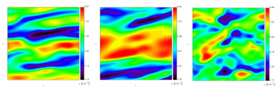
The first diagram (above) is a series of horizontal plan sections that present the results of a 2007 California study that attempted to improve existing WRF weather prediction models to take into account the effects of buildings. However, the simulation of the urban environment was an extremely simple case (a rough plane) that did not actually simulate an urban environment. (1)
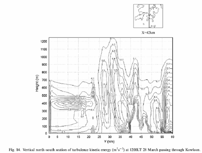
The second diagram (above) is from a 2006 study in Hong Kong that attempted to improve the resolution of existing mesoscale climate models. The research team chose Hong Kong due to its complex terrain and dense form of urban development, and compared predicted air flow in the improved model with actual observed measurements. The diagram illustrates air turbulence along a vertical section that cut through Hong Kong. According to the study: “Urban boundary layer models are under continual development and improvement… The customary way to handle urban areas is by using a mesoscale meteorological model with a refined grid (several kilometers).” The study team strove for a resolution of 500m, since “the rapidly advancing capabilities of computers, and the wide application of remote sensing techniques in meteorology makes models with higher resolution possible.” (2)
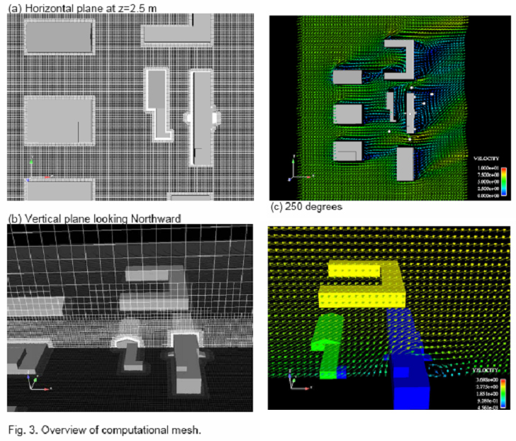
On the other end of the spectrum, "ultra high resolution" CFD models continue to be refined to better reflect real world conditions. A recent paper illustrates (below) the results of CFD testing that attempted to model the affect of varying wind directions and clusters of buildings. (3) There is clearly an opportunity to join this sort of fine-grained knowledge with the larger scale models discussed earlier.
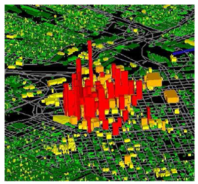
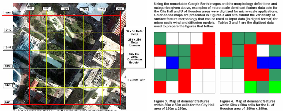
Attempts are being made to increase the availability (and access) to high resolution models of urban areas for climate simulation purposes. A good example is the National Urban Database and Access Portal Tool (NUDAPT) project. Sponsored by the EPA, this project is initially focusing on Houston as a prototype, providing a detialed model of the city's "urban morphology" and "urban canopy." The completed model database will be incorporated into a web-based "community" accessible structure. Examples of the tool below, show the conversion of LIDAR data into a 3D model (4), and the refinement of the currently standard 250m resolution "morphology" grid into a more refined 50 m grid.(5)
Sources:
1) Lundquist, Julie K. et al. “An Improved WRF for Urban-Scale and Complex-Terrain Applications.” American
Meteorological Society’s 7th Symposium on the Urban Environment, San Diego, CA, paper 11.1. 2007.
2) Tong, Hua et al. "Numerical simulation of the urban boundarylay er over the complex terrain of Hong Kong." Atmospheric Environment 39 (2005) 3549–3563.
3) Cionco, Ronald et al. "Preliminary Results of CFD Simulations for the Scenario of a Recent Field Study in an Urbanized Domain." American Meteorological Society’s 7th Symposium on the Urban Environment, San Diego, CA, 2007.
4) Ching, Jason. "National urban database and access portal tools (NUDAPT): a project overview."
5) Cionco, Ronald M. and Ellefson, Richard. "Microscale Aspects of NUDAPT."