- Social Acceptance
- Case Studies
- Urban Wind Behavior
Consolidating Urban Wind Measurement
- Reflections
- Contact

Understanding Urban Wind Behavior: Consolidating Urban Wind Measurements
Understanding the behavior of wind in cites depends on access to a much larger set of meteorological observation points than is typically used to measure and predict large scale climate patterns. Several studies on air movement at the urban scale are currently ongoing. Though each has a different purpose and uses different techniques, they share two common themes:
1. Current climate observations and urban air movement models do not take into account the complexity of the urban environment.
2. The welfare and safety of urban residents depends upon a better understanding of air flow in cities. This includes a better understanding of smog, particulate matter, and other air pollutants. However, each of the studies seems driven especially by concerns about accidental or terrorist releases into the urban atmosphere.
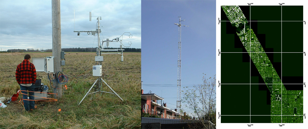
Image Credits: www.epicc.uwo.ca
Environmental Protection in Canadian Cities (EPiCC)
Montreal and Vancouver
The EPiCC network (pictured above) is a multi-year (2006 - 2009) project intended to provide a version of the TEB-ISBA (Town Energy Balance - Interactions Soil-Biosphere-Atmosphere) model optimized and verified for conditions found in Canadian cities. The EPiCC project seeks to better understand the urban atmosphere through observation, modeling and remote sensing...This enhanced forecasting capability will allow better understanding of the dispersion of smog and particulate precursors in urban environments, accidental and terrorist releases, heat stress and wind chill, and dispersion of air pollutants in urban environments. (1)
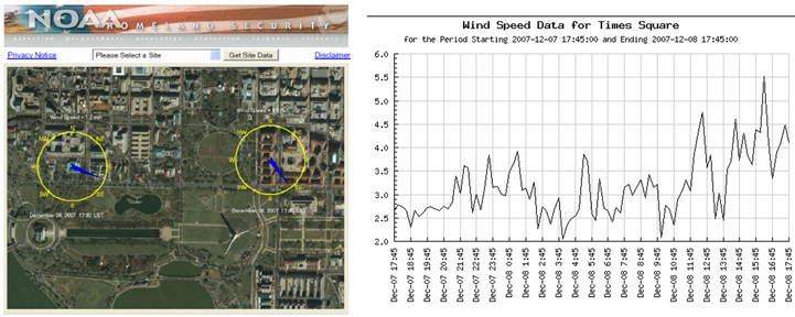
Image credits: dcnet.atdd.noaa.gov
UrbaNet
Under a "public/private meteorological partnership", NOAA and AWS Convergence Technologies are exploring the use of local meteorological networks for improved all-hazards urban forecasts. Under Congressional direction, initial studies focused on the Washington D.C. region as well as ten additional U.S. metropolitan areas (above). "This work targets one specific need – to extend NOAA's dispersion forecasting capabilities into urban areas. The network will provide data on wind velocity, averaged over fifteen minute periods, and accompanying evaluations of the variability of each wind component." Real time data for the different urban weather stations can be downloaded at the project website. (2)
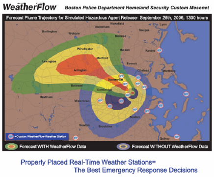
WeatherFlow / Boston Homeland Security Mesonet
WeatherFlow Inc. is being funded by the City of Boston to provide twenty additional surface data observing sites in and around the Boston metropolitan region. The goal of this enhancement project is to design, site, install, and maintain a mesonet that, along with existing infrastructure, gives the Boston Police Department the best continuous depiction of surface winds within the metro area. The resulting modeling capability is intended to allow much more accurate predictions of airborne releases, due primarily to the numerous added weather stations.
Sources:
1) EPiCC <www.epicc.uwo.ca>
2) UrbaNet <www.arl.noaa.gov/hls> <dcnet.atdd.noaa.gov> and <dataviewer.atdd.noaa.gov/website/noaadata/viewer.htm>
3) WeatherFlow <www.weatherflow.com/clients.php?c=342>