


The Cretaceous-Paleogene Deccan Traps
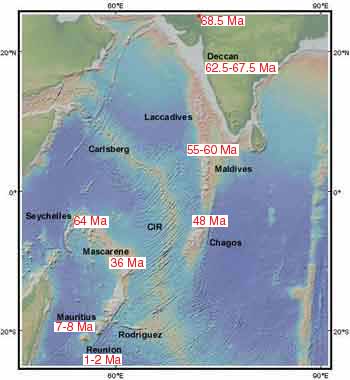 The Cretaceous-Paleogene (K/Pg) Deccan Traps of is one of the largest continental flood basalt provinces on earth. It covers an area of more than 500,000 km2 in western and central India and a large additional area offshore of western India. The estimated volume exceeds ~512,000 km3. It predominantly consists of a nearly-horizontal, sub-aerially erupted basaltic lava sequence with a maximum thickness of ~3.4 km. The lavas were emplaced by catastrophic eruptions that have been implicated as a major cause for the K/Pg mass extinctions. The Deccan province is located at the northern end of a hot spot track that originates at the Reunion Islands in Indian Ocean where a volcano is still active. Along the hot spot track, the basalts show a northward age progression with the ~66 Ma Deccan basalts being the oldest. Basalts of similar composition and age also occur on the submarine Mascarene Plateau and Seychelles Islands in Indian Ocean, indicating that these regions were adjacent to the Indian west coast at the time of the Deccan eruptions.
There is a region of anomalous mantle perturbation north of Mumbai that may have originated by the impingement of a deep mantle plume at the base of the lithosphere. Two and three-dimensional gravity modeling indicates the presence of mafic-ultramafic bodies in the upper crust. These include a large north-south elongated body south of the anomalous region along the N-S oriented western continental margin rift, and smaller bodies along the ENE-WSW oriented intra-continental Narmada-Tapti Rift in western and central India. Incompatible trace element variations in the basalts indicate that the parental mantle-derived melts evolved by fractional crystallization without crustal assimilation in the anomalous region, but with significant crustal assimilation away from the region. The upper crustal mafic bodies in the Narmada-Tapti Rift probably formed by emplacement of mantle-derived magma through eastward channeling along the rift.
The main Deccan sequence consists of tholeiitic lava flows at the Western Ghats escarpment, roughly parallel to the Indian west coast. Similar tholeiitic sequences occur along the Narmada-Tapti Rift in western and central India. The northwestern part of the Deccan including the Saurashtra peninsula and the Kachchh region of Gujarat consists of tholeiitic, picritic and mildly alkaline basaltic flows and dikes, and minor felsic, alkalic and carbonatitic rocks in isolated magmatic centers. There are several alkalic igneous complexes associated with the NNW-SSE oriented Barmer-Cambay Rift in the northwestern part, the mid-continental Narmada-Tapti Rift, and the western continental margin rift. Mildly alkaline basaltic flows are interlayered with tholeiitic flows near the western end of the Narmada-Tapti Rift (Rajpipla-Navgam area). The Narmada-Tapti Rift and the region near the Indian west coast host two prominent mafic dike swarms that are oriented ENE-WSW and N-S, respectively. There is also a cluster of randomly oriented mafic dikes northeast of Mumbai that cut across the lower Deccan formations of Western Ghats. In Saurashtra, the dominant E-W to ENE-WSW oriented dike swarm constitutes a westward extension of the Narmada-Tapti swarm.
Clinopyroxene-liquid and clinopyroxene composition thermobarometry indicates that all Deccan tholeiites including picrite, high-Mg basalt and low-Mg basalt crystallized in the upper crust at maximum pressures of ~6 kbar and a temperature range of 1047-1221 oC. By contrast, the Deccan alkalic rocks crystallized at maximum pressures near the Moho (~12.7 kbar) and a broad range of temperatures (978-1289 oC). Samples of high-Mg Deccan tholeiite that represent unmodified magmatic liquids are extremely rare. Reverse fractionation modeling indicates that the primary magmas of selected high-Mg basalts and a few low-Mg basalts that represent liquids were last equilibrated with the mantle at P-T conditions of 10-13 kbar and 1289-1333 oC. The primary magmas of very high-Mg basalts (MgO 11-12 wt%) and a picrite representing liquids that are even rarer, were last equilibrated with the mantle at P-T conditions of 25-36 kbar and 1452–1531 oC. Thus, the primary magmas of very high-Mg basalts and picrite were last equilibrated with garnet lherzolite, whereas the primary magmas of low-Mg and high-Mg basalts were last equilibrated with spinel lherzolite. The primary magma of a mildly alkaline basalt interlayered with low-Mg and high-Mg basalts was also last equilibrated with spinel lherzolite at similar conditions. The selected high-Mg basalts are 1-6% contaminated with the continental crust. Mantle potential temperatures based on the equilibration temperatures of the Deccan samples are 1400-1450 oC for the high-Mg and low-Mg basalts, and ~1500 oC for the picrite and the very high-Mg basalts. These results support derivation of the Deccan tholeiites from a mantle plume.
The Deccan alkalic rocks were emplaced either early or late, and the Deccan felsic rocks were emplaced contemoraneously with the voluminous tholeiites. The strongly SiO2-undersaturated alkalic rocks crystallized beneath the Moho, and their primary magmas originated from H2O+CO2 bearing, Ti-poor (0.7 times) to Ti-enriched (1.3 times) garnet lherzolite sources. The temperature of the alkalic melts at the base of the lithosphere was ~1285-1325 oC. The felsic rocks of the Saurashtra region (NW Deccan Traps) originated by almost complete melting of the upper continental crust with heat from the intruding basaltic magma. Zircon and monazite saturation thermometry indicates that the Saurashtra crust may have been heated to approximately 900 oC.
The Early Cretaceous Rajmahal Traps
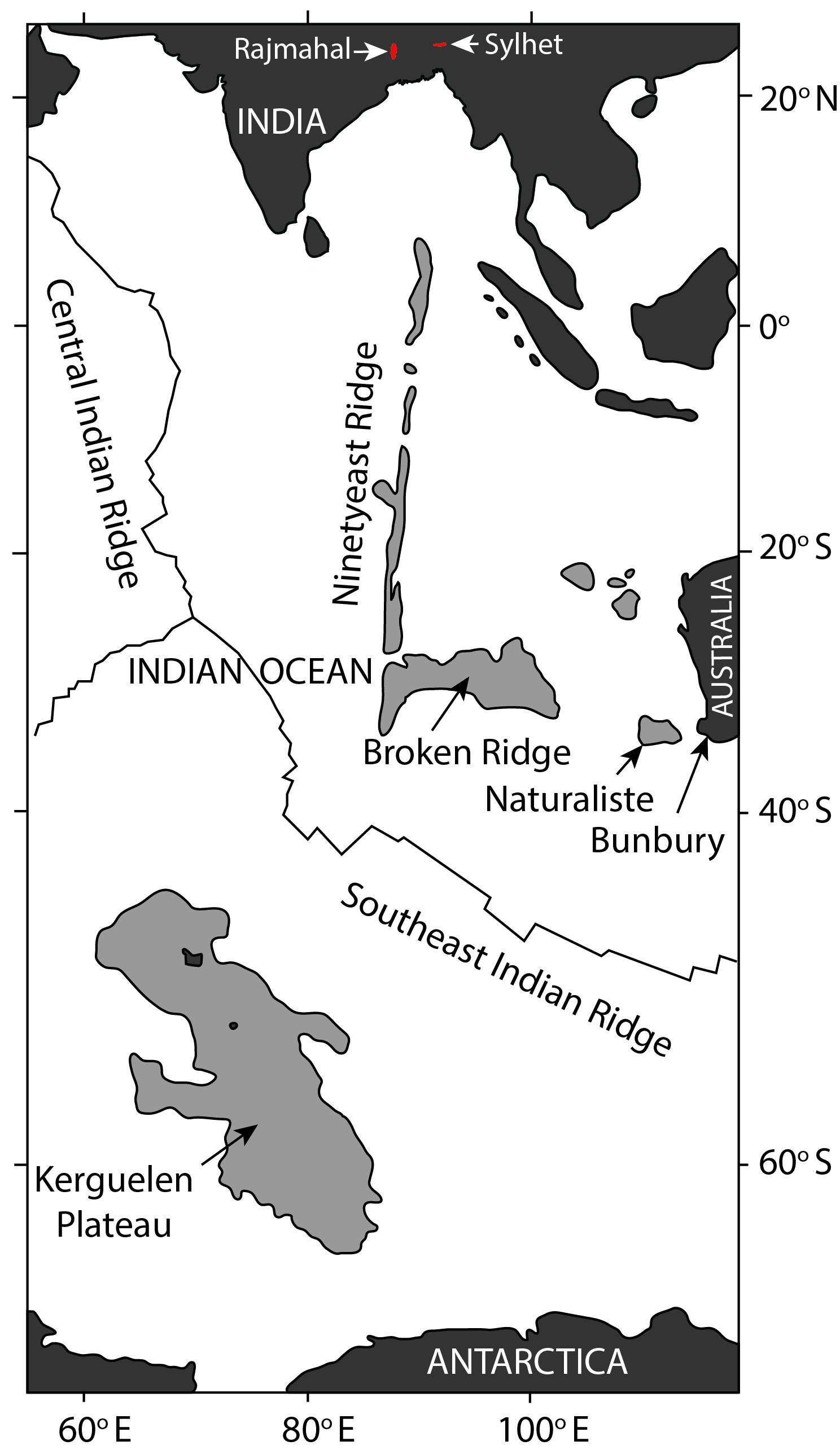 A Large Igneous Province related to the activity of the Kerguelen Plume has been recognized in eastern India, southwestern Australia (Bunbury), the eastern Antarctic margin, the Kerguelen Plateau, the Ninetyeast Ridge, the Broken Ridge, and the Naturaliste Plateau. The oldest basalts (~132 Ma) erupted in southwestern Australia. However, there are some reports of even older Kerguelen Plume-related volcanic activity at ~145–130 Ma in the eastern Himalayas. The eastern Indian basalts and most of the basalts of the Kerguelen Plateau erupted during the peak of Kerguelen Plume activity at ~120–95 Ma. In eastern India, the Late Aptian (~118–114 Ma) Rajmahal–Bengal Basin–Sylhet Traps and the associated dolerite dikes and alkalic-carbonatitic-ultramafic intrusives comprise a large flood basalt province. The Rajmahal and Sylhet Traps are located in the western and eastern parts of the province, and drill-core data indicate that the two are continuous under the Gangetic alluvium of the Bengal Basin. The Rajmahal Traps (area: ~4300 km2) are exposed along the N-S oriented Rajmahal Hills in the northern part of the eastern margin of the Proterozoic Chotanagpur Gneissic Complex (CGC). The CGC forms the basement of the Gondwana Supergroup, the uppermost part of which contains the Rajmahal basalts. The Rajmahal flows are sub-horizontal with the dip increasing to ~5° eastward at the eastern flank of the hills, and the total thickness of the flows increases from ~230 m in surface exposure to >332 m subsurface in the Bengal Basin. The thickness of individual flows varies from <1 m to 85 m. Thin beds of shale, black shale, mudstone, siltstone, cross-bedded sandstone, and oolite associated with bentonite lenses and volcaniclastic rocks occur between lava flows in the lower one-third of the volcanic sequence, indicating sub-aqueous eruptions during the early phase of volcanism. The upper part of the sequence is devoid of sedimentary and volcaniclastic rocks, and consists of subaerially erupted lava flows. The volcanics are dominated by tholeiitic basalt and basaltic andesite with minor trachyandesite, andesite, dacite and rhyolite, and rare orthopyroxene-bearing basalt and andesite.