|
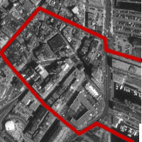
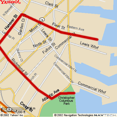
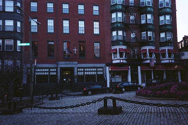
The Basic History of My Site Since my site was first founded and settled, it has been a place for people to live and congregate. At first, it was a highly residential area where many prominent and wealthy English residents lived. However, because of the proximity of the wharves, the area slowly grew to become much more commercial and industrial. As the area became more commercial, new residents moved into the area. These newcomers were much different from the original founders. Not only did the new residents have different national origins, they had a much different economic and social status. Slowly, the original residents moved out and were replaced by the newcomers. This pattern repeated itself, with new immigrants moving into the area and slowly pushing the older residents out. During this time, the area became even more industrialized and commercialized. Residential homes and apartments were knocked down and converted into shops, restaurants, and industrial areas. As the population continued to grow, the remaining houses were renovated and rebuilt to accommodate the growing population. At the present time, my site is still highly residential. However, the bordering areas and parts of the site have become centers of industry and business. Slowly, the commercial areas are expanding. The quaint, residential feel of my site is slowly slipping away. |
|
|
|
As time has passed, all of these changes have left marks on my site. There are old buildings and houses that date back to the time of the original settlers. They tell much about the people who once owned and lived in them. Also, there are several other artifacts and layers that trace back to the time of the original settlers. Although my site has gone through a lot of change, the basic trends can still be found hidden amidst the buildings and apartments. |
|
The First Residents (1650-1800) The first people to settle the North End were the wealthy and proper Englishmen. While most of them were Americans (in allegiance), a few residents were stationed there as British soldiers. There were also several Jewish people who lived in the area and created most of the businesses. During this period, my site was highly residential. There were only a few shops and restaurants in the area, which were mostly run by the Jews. Most of the houses in the area were very large mansions built in the Georgian style. They were often adorned with wood and stone carvings. Gardens were also added to several of the mansions built in the area. Also, a school and church were built on my site to serve the residents and their families. |
|
|
|
Several of the houses on my site contain artifacts that trace back to this period. On the corner of Garden Court Street, there is a large wooden column attached to one of the older buildings. There are several carvings on the wood that seem to be of very high quality. Unlike most of the other traces on my site, this one does not show any visible signs of decay or deterioration. The carvings depict several flowers and vines intertwined around large, carved letters and numbers. The rest of the building is relatively large and made of red brick. This house used to be the mansion of Governor Thomas Hutchinson. Now it has been renovated and converted into apartments. Two other houses on my site have ornate stone carvings on them. One of them is on Lewis Street (Figure 4), the other on Garden Court Street (Figure 5). Both have elaborate stone carvings around the windows. The carvings depict winding vines, plants and wreaths. However, the stone on both houses has been heavily corroded with time. Why these traces were saved while all the surrounding buildings were destroyed and remodeled, I do not know. However, I would assume that these carvings were more elaborate and the buildings more expensive than those surrounding them. Therefore, the new owners decided not to destroy them, but instead remodel the interior. Another mansion, also on Garden Court Street, used to be the residence of John J. Fitzgerald. During his life, Fitzgerald was a very wealthy man who became a ward boss, mayor, and congressman. After he moved out, his house was converted into apartments and a restaurant. However, there are still remains of a garden at the top of the building. The restaurant has utilized these structures and now grows plants and has a quaint garden of its own. |
|
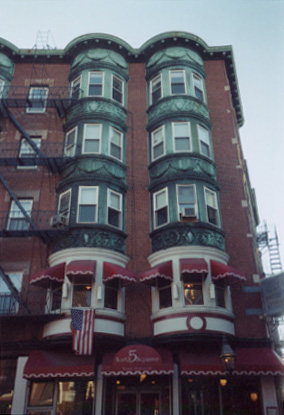
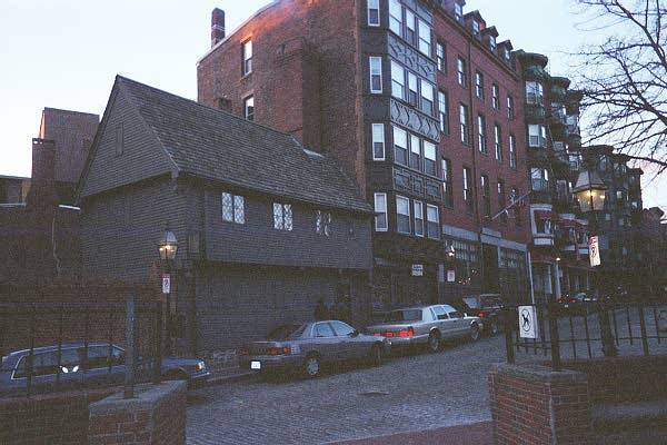
The most famous house on my site is Paul Revere's House (Figure 6). However, it does not look like the other artifacts at all. The house is made of wood and is very irregular and asymmetrical. There are no stone or wooden carvings on or around the house. Nor are there gardens. Paul Revere and the original owner, Robert Howard, were wealthy merchants who had earned their money through trade, not family inheritance. They did not want their house to be made in the English style with carvings and gardens. Instead, they were more interested in purpose. When it was originally built, it was an exception in the area. However, as time went by and new residents moved in, new houses that were built followed this style, more for a purpose than comfort and beauty. |
|
|
Even though these artifacts are not in great condition, they trace back to the early residents of my site. They show the wealth and high living style of the early residents. They must have had a lot of money in order to build these grand mansions. Also, their English background is quite apparent. The style of the mansions and gardens is very English in origin. They were trying to create a little replica of the wealth and beauty of their native country. When these mansions were first built, they must have looked very impressive. The presence of such buildings would have awed the common people with the presumed wealth and prestige of their residents. The owners must have had large egos and been very proud of themselves. Just looking at these artifacts and traces of past mansions tells a lot about the people who first built homes and resided in this area. During this time period, a school and church were also built in the area to serve the new residents. The school, which was built on Moon Street, is one of the oldest schools in the United States. It was a Puritan school that taught the children of the wealthy residents around North Square. Children of less wealthy parents were not allowed to attend the prestigious school. This school helped to bring together the new residents and create a real community. The original building is still standing, although the interior has gone through several renovations. It follows the style of several English schools of the time. The Second Church was also built on Moon Street during this period. It was a built by the Puritans as a second place to congregate after the First Church in downtown Boston became too crowded. However, the church was burned down, rebuilt, and then destroyed for firewood. There are no artifacts left from the church, except for a plaque marking the site. However, at the time, it probably helped to form a closer community of the early residents of North Square. | |
|
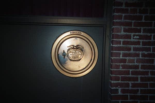
Although there was not much commercialization in my site at that time, the Jewish residents did own a few shops and restaurants. Also, they built a bank in the area. In a window of one of the office buildings on Atlantic Avenue, there is a golden-colored vault door (Figure 7) that has, "First National Bank of Boston 1784," printed on it. This bank was probably built and run by the Jewish population in the area. While my site was mostly residential during this early period, there was still some commercial activity going on. |
|
|
|
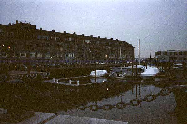
The Sailors and Irish (1800-1900) After the Revolution, my site became much more commercialized and industrialized. The proximity of the ports (Figure 8) made the area a hub for sailors and merchants. Also, the area became the home of thousands of Irish immigrants that had left during the Great Potato Famine of 1846. As all these new people moved in, the past residents moved out. Many of the older mansions were renovated into apartments for the sailors and immigrants. Also, many institutions were built for the new residents, including a church and a mariner's house. Most importantly, the bay was filled in, creating much more land to develop. Most of this new land was used for commercial and industrial purposes. The area shifted from being heavily residential to being highly commercial and industrial. |
|
On a few of the houses on my site, there are dates set into the walls that go back to this period. These houses (Figure 9) are very narrow and high. They are made of stone or brick, but do not have any type of decoration. The rooms seem to be very small and compact. These houses were probably the most common residence in the area at the time. They show that the residents cared more about making money than living in comfort and beauty. It was the new mentality of all the residents of the area. |
|
|
During this time, one of the older churches was renovated into the Seamen's Bethel. This church was built specifically for the sailors as they constantly came and went from the ports. While the Seamen's Bethel is not there anymore, the building was renovated and turned into Sacred Heart Church, which is still there today. This artifact was built to serve the new types of residents that had overwhelmed the area. It became a part of my site and helped bring all the residents together amidst constant flux and change. | |
|
The Mariner's No. 11 House (Figure 10) was built on Garden Court Street during this time. The Boston Port Society built the house as a private residence for merchant marines. It was a place for these sailors to stay and relax between their long trips at sea. This building, like the Seamen's Bethel, was built to help and support these new residents. It shows the changing mentality and life-styles of the residents in the area. |
|
|
|
During this time, the bay was filled in and the new land was developed. The wharves and new land became almost completely commercial and industrial. Many factories and companies were built in this new area. For example, in one of the parking lots by Atlantic Avenue, there is an old sign that says, "Oil Delivery - No Parking," (Figure 11). However, there are currently no industrial areas around that parking lot. In fact, it has new signs up that say the parking lot is the property of the Boston Housing Authority (Figure 11). However, there used to be all kinds of commercial and industrial buildings in that area. |
|
The Italian Immigrants (1900-1960) At the turn of the century, a new group of Italian immigrants moved into the area. Slowly, these new immigrants replaced the Irish. These new immigrants converted the Seamen's Bethel into Sacred Heart Church to better serve their needs. Also, they built several restaurants in the area. As more land was converted to commercial use, several of the residential buildings were renovated and new floors were added. The living conditions deteriorated, as more people were crammed into smaller areas. | |
|
|
The Italians built all kinds of restaurants and other commercial buildings. Today, these restaurants still retain their purpose and are used every night by crowds of people who flock to the North End to eat authentic Italian food (Figure 12). Even though they seem so modern, they are actually historical artifacts that trace back to this period. |
|
During this time, the areas around the ports continued to grow. Since the ports were used less, many of the industrial companies moved. This space was soon bought and renovated for commercial purposes. The areas around the ports were built up and became increasingly commercial. This trend continued throughout the century. | |
|
The Present (1960-2002) About halfway through the century, the Italians started moving out of the area. However, they kept their restaurants and commercial businesses in the area. So now, there is a heavy Italian influence on my site, even though not many Italians live in the area anymore. | |
|
During this period, there was even more commercial growth. Almost all of the buildings along Atlantic Avenue were torn down and rebuilt into office buildings. Also, many of the apartments along Fulton Street have been renovated into office space. All over my site, commercial buildings are replacing residential ones. There are also Italian restaurants and shops scattered all over the place. Plus, a whole residential block was bought and replaced with a power plant (Figure 13). As time went by, there were less and less residential areas on my site. |
|
|
However, a few new residential buildings were built during this time. The Boston Housing Authority built the Ausonia Apartments in 1977. It is only for the elderly and disabled, but it is still a large, self-contained apartment complex that houses many people. However, several old residential houses and apartments were knocked down in order to build the Ausonia Apartments. While it is a much more structured housing system, it has not increased the number of residential areas on my site. The Columbus Housing was another new apartment complex built in 1978. It replaced an old industrial building that was close to the ports. This has been the only real increase in residential housing in the area. Also, it is a much different style of housing. Instead of being very small and cramped, it is large and spacious. The rooms are very nice and are built for comfort. The owners have tried to make the apartment complex very beautiful. There are two parks, one public and one private, with trees, bushes, and benches. Inside, they have large aquariums full of exotic fish, which make the place look really nice. This care for aesthetics and comfort shows the change in mentality from earlier times. However, it is the only residential housing of its type on my site. | |
|
The Future (2003-?) Because of the increasing commercial trends on my site, I believe that more and more residential housing will be bought and turned into commercial buildings. The commercial zones will expand from the ports and will slowly overcome almost all of the residential areas on my site. Also, I believe that several of the commercial buildings that were renovated from older residences will be destroyed and replaced with towering office buildings. I also think that some of the older apartments will be bought and converted into complexes like the Columbus Housing. This will allow the standard of living on my site to increase, although it will make housing much more expensive. Many people will be forced to move somewhere else since there are no more places for them to live. There will probably always be a few older apartments left, but I think they will become less crowded as people move out and the area becomes more commercialized. As time goes on, I believe there will be fewer artifacts and layers from older times on my site. However, I'm sure there will still be a few, although they may be much harder to find. |