|

|

Getting Started
Rapid Reconnaisance/surveying
|
|
Included are several excerpts: one is a an example of mapping with the community, another proposes simple but effective Tips for surveying in the often confusing, high density squatter areas, and the last are some cautions for understanding survey data.
Additional Resources:
Mathare Valley, A Case Study of Uncontrolled Settlement in Nairobi. Etherton, David. (Nairobi: Housing Research and Development Unit, University of Nairobi, 1974) This provides a detailed, step by step example of how a survey was conducted in the Mathare Valley squatter villages.
|
|
Example of Community Mapping
Experiences and tips on mapping out complicated
slum neighborhoods with the help of the residents
Excerpt form:
Housing by People in Asia. Newsletter of the Asian Coalition for Housing Rights. No 11, April, 1998.
Editor's note: The following is an example of a rapid, cheap, and sufficiently accurate way of mapping out communities for most purposes.
In Phnom Penh, the city surveyors had begun mapping one particularly poor slum—Basaac—but could never finish due to their unfamiliarity with the intricate maze of houses and streets. The residents, however, knew every bit of the place and could map it out with surprising accuracy.
|
“But in my head I'm counting…”
Measuring a big community like Basaac with tapes takes long and tends to frighten people who associate measurements with eviction plans. So the team measures with pacing instead. Vong Nov, for example, has a natural step, which is exactly 60 cm. Knowing this allows very long distances to be measured with great accuracy. Plus, ‘Nobody knows we're measuring. They think I'm just wandering and looking around. But in my head I'm counting!” (p 8)
|
|
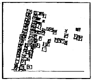 |
Map 1:
“First map by the community—it’s drawn right on site and is everybody's first try at getting all the lanes and everybody's houses onto the map. The scale and spatial clarity of these first maps is almost always astonishingly accurate.” |
 |
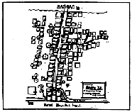
Map 2:
“There are several more rounds of checking and measuring, and each time, the map gets better, more detailed. When the community's map is ready and everybody is happy with it, they give it to Nay, Visal, and Keke, to check and re-draft at a smaller scale.” |
 |
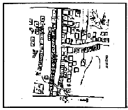
Map 3:
“After more checking and more back and forth, the team prepares this accurately-scaled version, using city survey maps for the outlines. On this, the community will mark house names, toilets, trees, bridges and light poles”
(p 8). |
|
|
Tips for Rapid Surveys
Excerpt from:
Asian Coalition for Housing Rights newsletter, Housing by People in Asia (No 11, April 1998) 5.
|
|
“Survey Tricks”
Taking an average: When you ask about problems and numbers in slums, people all have different answers. The Chiang Mai Network gets answers from as many people as possible, then gathers the whole team to fill out the form together, afterwards, taking an “average” of all the responses.
Splitting up: Teams can split up into separate tasks—question-askers, house-counters, boundary-measurers.
Getting Lost: Counting and mapping houses in big slums can get you lost in the maze of small lanes. When kids from the community of Sadak Chaap are helping survey, they work in teams—somebody plants himself at a central place while others go off in different directions and circle back to home base.
Steps and sarees: Instead of using a tape measurer, which not everybody understands, The group, Mahila Milan, in India, uses the width and length of a saree and Cambodian’s use pacing to measure lanes and houses they’re surveying.
Stopping for snacks: Paa Sarieem, from SUPF, an NGO in Phnom Penh, likes to make frequent pit stops when surveying, and conversations with the street-side fried-banana lady or the roasted-peanut man often lead the team to new settlements they wouldn’t have found otherwise.
|
|
Cautions about Survey Data
Things to keep in mind
Excerpt from:
Survey of Slum and Squatter Settlements. United Nations Centre for Human Settlements (Habitat). (Dublin: Tycooly International Publishing Limited, 1982)
|
|
Possible problems with survey data
What is considered by the population to be “tolerable density” varies from culture to culture and country to country. It may be more useful to make city to city comparisons within the same country.
What buildings are used for varies from culture to culture. Some people are only in the neighborhood at night for instance.
The full area (as in cubic meters) is usually not taken into account by surveyors.
Sometimes habitable space means shade under trees, porches, etc., which do not normally get counted.
Plots and buildings could be shared by multiple families and/or for multiple uses.
Slum and squatter settlement populations are fairly unstable so surveys may involve problems with accuracy.
|
|
|