Buoys Introduction
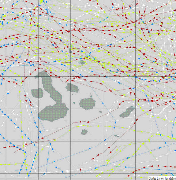
Currently, there are no permanent buoys in many parts of the Galapagos waters. The implementation of such a system would render multiple benefits to ecosystem monitoring, such as in the response of oceanographic and atmospheric variables to the construction proposals available in the ecovillage section. Below is a map from 2000 of drifting buoys and their trajectories over the year. Note the coverage absence near the geographical center of the Galapagos.
Drifting Buoy Movement
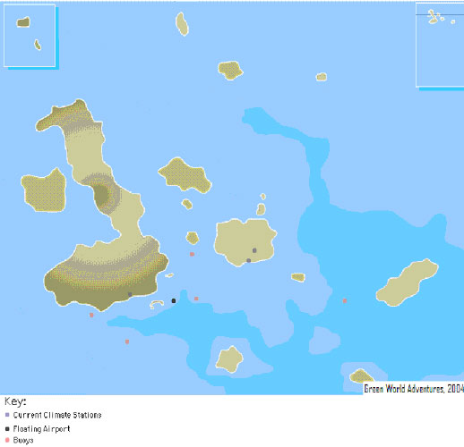
Five buoys are proposed, as shown below. Two are downstream from the proposed floating airport, one on the east side of the airport, one downwind from Puerto Ayora, and one downwind from Puerto Baquerizo Moreno. All five are strategically placed in the no coverage zone illustrated above. The three buoys surrounding the proposed floating airport will monitor changes in oceanographic variables, especially nitrate concentrations, before, during, and after the construction of the airport. The other two buoys, as stated, are downwind of Puerto Ayora and Puerto Baquerizo Moreno, so that atmospheric conditions can be measured.
Buoy Locations
The buoys will be anchored using the methods specified by the NOAA guidelines below.
Mooring Guidelines
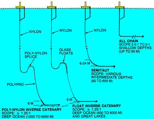
(NOAA)
They will be primarily solar powered, and will contain lithium battery packs capable of powering the buoys for about 24 months with data transmission occurring once per hour.
[top]
Sea Surface Temperature
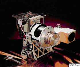
Satellites such as the Sea-viewing Wide Field-of-view Sensor (SeaWiFS), shown below, perform remote sensing of this parameter. SeaWiFSís spatial resolution is greater than one kilometer, but this is still sufficient to accurately know the surface temperature of the ocean at the buoy sites (Feldman). Satellites such as SeaWiFS can also monitor oil spills in the ocean, as was demonstrated when the Jessica dumped nearly 250,000 gallons of oil into the ocean. Temperature plays a significant role in the Galapagos ecosystem, especially in the marine environment. Many marine species are affected by a change of only a few degrees Celsius, which can occur in an El NiÒo season. The average temperature of Galapagos waters is about 22 degrees in September and 26 in February and March (FN and WWF, 2000).
SeaWiFS
[top]
Nitrates
Nitrates are an indicator of ecosystem productivity. Previous studies (e.g., James, 1991) have found that nitrate concentrations vary from 0 during El NiÒo to 5 micromolar at the surface in open ocean. The levels of this variable should be monitored closely during and after the construction of the floating airport so that any possible impact on the marine ecosystemís health can be identified and an appropriate response initiated. The results of the nitrate levels in the buoys can be used in conjunction with remote sensing of chlorophyll levels on the surface, which correlate to phytoplankton.
[top]
Disolved Oxygen
The buoys will incorporate dissolved oxygen sensors. Please visit the dissolved oxygen page in the ìterrestrialî section for a discussion on this parameter.
[top]
Air Temperature/Pressure/Precipation/Carbon Dioxide
These atmospheric parameters are inadequately monitored by direct means at the open ocean around some parts of the Galapagos. It would also be interesting to see how these parameters change during the proposed construction in the villages and of the floating airport.
[top]
Sources
- Feldman, G.C. SeaWiFS Project. An Overview of SeaWiFS and the SeaStar Spacecraft. Retrieved December 1, 2004, from http://seawifs.gsfc.nasa.gov/SEAWIFS/SEASTAR/
SPACECRAFT.html.
- FundaciÛn Natura, World Wildlife Foundation. (2000). Galapagos Report:1999-2000. Quito.
- James, M.J. (1991). Galapagos Marine Invertebrates. New York: Plenum Press.
[top]
Copyright! All rights reserved.
Webmasters