 |
|||||||
 |
 |
 |
 |
 |
|
 |
|
| |
|
||||||
 |
 |
 |
 |
 |
 |
 |

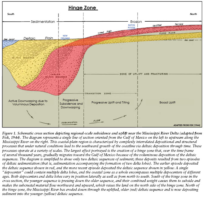
Subsidence has been taking place around the Lower Mississippi since the Jurassic period. Studies suggest that the reason is the settlement of sediment in the Mississippi River delta, which piles up and weighs down on the crust of the underlying coastal plain. The crust bends down here, which causes nearby inland areas to be pushed up (see figure 1). The “hinge” between the areas of uplift and subsidence is farther inland than New Orleans, however, so New Orleans experiences subsidence (Dokka, 2005; McCulloh, Heinrich, Good, 2006)
(McCulloh,
Heinrich, Good 2006)
A new subsidence map, with data collected from satellites, contains recent subsidence data and shows that some areas in New Orleans have been subsiding faster than previously imagined. Consistent with previous data, the map shows an average subsidence of about 8 mm/year (Dixon et al., 2006; Dokka, 2006). It also shows significantly higher rates in areas like Lakeview, Kenner, the borders of the St. Bernard Parish, and New Orleans East. Most strikingly, the new data show extensive subsidence at the levees for the MR-GO channel, a site of major flooding during Katrina (Van Heerden, 2005). These levees have subsided by about a meter in the past three decades; this would certainly have exacerbated over topping, and most likely weakened them structurally (Dixon et al., 2006).
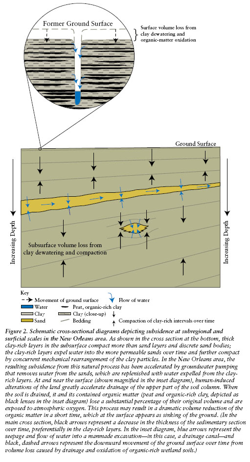
A major reason cited for recent subsidence in the New Orleans area is the fact that much of the city, such as New Orleans East, was built on drained wetlands. Drainage projects by their nature lower groundwater levels, and this in turn lowers the pressure supporting the land. This leads to compaction of the soil (Dokka, 2005; Dixon et al., 2006). The wetlands are also vulnerable to compaction because of the type of sediment they are made up of: largely, unconsolidated organic matter. When wetlands are drained, and the soil dries out, the anaerobic soil is oxidized, which also contributes to compaction (McCulloh et al., 2006).
(McCulloh et all, 2006)
In 1913 and 1915, new pumps were developed, and water was pumped out of the wetlands, over the levees around the city. The newly dried out soil was now possible to build on, and housing development increased around and after World War II (McCulloh et al., 2006).
Recently scientists have been looking at tectonic movement as a major cause for subsidence around New Orleans. Historic evidence has suggested that during the 1960s and 1970s, the exceptionally high subsidence rates were caused by the Michoud fault, which lies under New Orleans East (Dixon et al., 2006). During 1969-1971 and 1971-1979, tectonic motion was responsible for 16.9 mm/year and 7.1 mm/year respectively, these figures accounting for 73% and 50% of subsidence in their respective years. The study attributes a remaining 6-7 mm/year to other causes, like compaction. The fault has ceased activity in the last 10 years, but the subsidence attributed to other factors remains constant, and consistent with other recent studies. As such, this new way to account for subsidence is not actually at odds with other theories (Dokka, 2006).
How do we deal with subsidence? Other geographic areas have experienced similar phenomena and strategies for preventing it have been implemented. In the Harris and Galveston districts in Texas, for instance, subsidence has been attributed to overdrawing of ground water, a similar situation to New Orleans. The organization of the Harris-Galveston Subsidence District has recommended limiting the amount of groundwater available for use, to avoid the pressure reduction that leads to subsidence(Harris-Galveston District, 2005).
Wetlands, under proper circumstances, can compensate for subsidence themselves. When the river delta is depositing sediment on them, it builds up the land, counteracting the sinking. Also, certain plants that grow in the wetlands can form root networks that actually float, so that when the land sinks relative to the water, the vegetation can stay in place. However, both of these mechanisms are being broken down by human interaction; sediment deposition is stemmed because of control over the river, and the root networks cannot be formed with saltwater intrusion (Coast 2050, 2006).