 |
|||||||
 |
 |
 |
 |
 |
|
 |
|
| |
|
||||||
 |
 |
 |
 |
 |
 |
 |

Formation of a Tropical Cyclone
Tropical Cyclone
A tropical cyclone is a
warm-core, low pressure system with an organized circulation that forms
over
tropical or subtropical waters. In the Atlantic/East Pacific Oceans, it
is
called a hurricane. In the
Conditions
to Form
There must exists several favorable conditions for a tropical cyclone to form:
- Warm ocean water (at least 80˚F/ 27˚C) through a depth of about 150 feet
- An atmosphere that cools fast enough with ascension that it is potentially unstable for moist convection.
- Moist air near mid-level troposphere
- A minimum distance from the equator of about 300 miles (but not within 5˚ latitude)
- A disturbance near the surface
- Low vertical wind shear between surface and troposphere (of less than 23mph).
Note: Wind shear is the change
in wind speed with height. Additionally, a tropical cyclone must be
close to
the equator to form, but, except rare cases, do not form within 5˚
latitude of
the equator because of the lack of Coriolis Force. This force is what
causes
the cyclone to spin. The direction it spins depends on the hemisphere
it which
it is located. In the Northern hemisphere, it spins counter-clockwise;
in the Southern
hemisphere it spins clockwise. (National
Weather Service)
Seven
Regions of Formation
Storms form within seven regions of the earth:
- Atlantic basin
- Southeast Indian/Australian basin
- Australian/Southwest Pacific Basin
Our interest lies in the
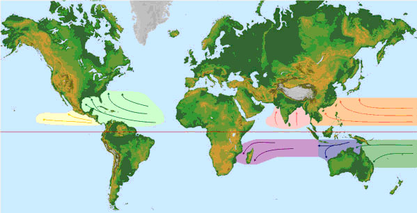
Seven Regions of Tropical Cyclone Formation
National
Weather Service)
Disturbances
(Causes)
Several disturbances work to trigger the
formation of a
tropical cyclone.
Tropical Cyclone Disturbances
|
Easterly Waves |
Also known as tropical waves; inverted trough of low pressure moving westward in the tropical easterlies. A trough is a region of relative low pressure. This is how most major storms form. |
|
West African Disturbance Line |
Line of convection the forms over West
African moves into the |
|
Tropical Upper Tropospheric Trough (TUTT) |
A trough, or cold-core low in the upper atmosphere, produces convection, Sometimes forms warm-core tropical cyclone. |
|
Old Frontal Boundary |
Remnants of a polar front can become
lines of convection and generate a tropical cyclone. Can form storms
early or late in hurricane season in the Gulf or |
Strength
of a Cyclone
Once a tropical cyclone system with organized circulation forms, it can become more organized if it stays over warm waters and upper level winds (wind shear) remain weak. Key to its power is warm water and war moist air. A storm is propagated when water vapor cools and rises. It condenses into clouds, releasing heat which warms the surrounding atmosphere. The air becomes lighter and continues to rise and more air rushes in its place, which are the strong winds we feel from storms.
When the eye of the storm moves over land, it lacks the moisture and heat that power the storm and convection. It weakens and eventually diminishes.
(National
Weather Service)
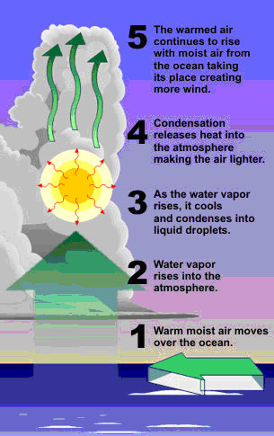
*Convection that Powers Tropical Cyclones
(National
Weather Service)
Why
do Hurricanes form?
Why is it important that they form? The
tropical cyclones role
is to take heat stored in the ocean and transfer it to the upper
atmosphere
where upper level winds carry the heat to the poles. This is important
because
its is what keeps the
Tropical cyclones help regulate
the earths temperature. Therefore, it
would not be wise to disrupt a cyclone’s intensity because oceans will
retain
that heat. Over time, a heat build-up could enhance successive storm
and
increase their frequency and intensity. (National
Weather Service)
Tropical
Cyclone Structure
“Imagine standing at the center of a Roman coliseum that is 20 miles across, with walls that soar 10 miles into the sky, towering walls with cascades of ice crystals falling along its brilliantly white surface. That's what it's like to stand in the eye of a hurricane.” Kerry Emanuel in Divine Wind
(Emanuel
2005)
Main
Parts of a Hurricane
The main parts of a tropical cyclone include the rainbands, the eye and the eyewall. A cyclone is basically air that spirals to the center, up through the eyewall, and out the top in the opposite direction. In the center, air also sinks in attempt to fill the empty space that consists of the eye. The eye is a cloud-free, calm, clear region with light winds (no more than 15mph). It usually forms when the storm reaches 74mph winds or more.
The eye is formed by a
combination of angular momentum and centrifugal force. Because of
conservation
of momentum, as air approaches the center, its speed increases. The
increased
speed of spiraling air creates a centrifugalforce that wants to pull it
outward, thus forming an clear eye with strong winds in the eyewall.
Rising eye
in the eye create the eyewalls.
(National
Weather Service)
The eyewall consists of bands of clouds, strong winds and heavy rains. It is the strongest of the storm with rings of tall thunderstorms.
The rainbands, or feederbands,
are bands of showers, gusty winds, and often heavy rain with gaps into
bands.
They become more pronounced as a storm intensifies. These bands are
curved and
trail away for the center in a spiral-like fashion. Rainbands
often include bursts of rain and
wind and tornadoes.
(
(National
Weather Service)
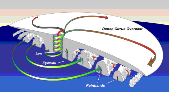
Structure of a Tropical Cyclone
(National Weather
Service)
The size of a hurricane averages near 300
miles wide with
great variations. The size of the storm is not an indication of the
hurricane’s
intensity. Hurricane force winds are felt out to about 150 miles from
the
center. Tropical-force winds extend out 300 miles from the center.
Tropical
Cyclone Classification
A tropical cyclone is classified according to wind speed values. A system with organized circulation with wind speeds less than or equal to 38 mph is called a tropical depression. Once it reached 39 mph, it is called tropical storm and given a name. Wind speeds of 74mph or higher is classified as a hurricane.
|
Classification |
Wind speeds |
|
Tropical Depression |
Less than or equal to 38mph |
|
Tropical Storm |
39mph or greater |
|
Hurricane |
74mph or greater |
Hurricanes are classified according to the Saffir-Simpson scale (Category 1-5) based on the wind speeds of the hurricanes. The scale estimated the potential property damage and flooding along the coast from hurricane landfall. Storm surge values are highly dependent on the slope of the continental shelf in the landfall region.
|
Cat. |
Wind |
Water |
Cat. |
|||||||
|
Speed |
Damage |
Storm Surge |
Effect |
|||||||
|
1 |
|
No real damage to building structures. Damage primarily to unanchored mobile homes, shrubbery, and trees. Some damage to poorly constructed signs. |
Generally |
Low-lying coastal roads inundated, minor pier damage, some small craft in exposed anchorage torn from moorings. |
1 |
|||||
|
Examples: Hurricanes Allison of 1995 and Danny of 1997 were Category One hurricanes at peak intensity. |
||||||||||
|
2 |
|
Some roofing material, door, and window damage of buildings. Considerable damage to shrubbery and trees with some trees blown down. Considerable damage to mobile homes, poorly constructed signs, and piers. |
Generally |
Coast roads and
low-lying escape
routes inland cut by rising water 2 to 4 hours before arrival of
hurricane center. Considerable damage to piers. |
2 |
|||||
|
Examples: Hurricane Bonnie of 1998 was
a Category Two hurricane when it hit the |
||||||||||
|
3 |
|
Some structural damage to small residences and utility buildings with a minor amount of curtainwall failures. Damage to shrubbery and trees with foliage blown off trees and large tress blown down. Mobile homes and poorly constructed signs are destroyed. |
Generally |
Low-lying escape routes are cut by rising water 3-5 hours before arrival of the hurricane center. Flooding near the coast destroys smaller structures with larger structures damaged by battering of floating debris. Terrain continuously lower than 5 ft above mean sea level may be flooded inland 8 miles (13 km) or more. Evacuation of low-lying residences within several blocks of the shoreline may be required. |
3 |
|||||
|
Examples: Hurricanes Roxanne of 1995
and Fran of 1996
were Category Three hurricanes at landfall on the Yucatan Peninsula of
Mexico and in |
||||||||||
|
4 |
|
More extensive curtainwall failures with some complete roof structure failures on small residences. Shrubs, trees, and all signs are blown down. Complete destruction of mobile homes. Extensive damage to doors and windows. |
Generally |
Low-lying escape routes may be cut by rising water 3-5 hours before arrival of the hurricane center. Major damage to lower floors of structures near the shore. Terrain lower than 10 ft above sea level may be flooded requiring massive evacuation of residential areas as far inland as 6 miles (10 km). |
4 |
|||||
|
Examples: Hurricane Luis of 1995 was a
Category Four hurricane while moving over the |
||||||||||
|
5 |
|
Complete roof failure on many residences and industrial buildings. Some complete building failures with small utility buildings blown over or away. All shrubs, trees, and signs blown down. Complete destruction of mobile homes. Severe and extensive window and door damage. |
Generally |
Low-lying escape routes are cut by rising water 3-5 hours before arrival of the hurricane center. Major damage to lower floors of all structures located less than 15 ft above sea level and within 500 yards of the shoreline. Massive evacuation of residential areas on low ground within 5-10 miles (8-16 km) of the shoreline may be required. |
5 |
|||||
|
Examples: Hurricane Mitch of 1998 was a
Category Five hurricane at peak intensity over the western |
||||||||||
|
Cat. |
Speed |
Damage |
Storm Surge |
Effect |
Cat. |
|||||
|
Wind |
Water |
|||||||||
(National Weather Service)
Hurricane Names
Once a tropical
cyclone is considered a hurricane, it is given a name. There are six
lists of
names that rotate every hurricane season. There are no names that begin
with the
letter Q, U, X, Y, and Z because of the scarcity of the names. Once the
list of
names is used up for the season, the Greek alphabet is used. The names
of major
land falling storms that may have a major economic impact are retired.
Examples
include Katrina, Rita, Wilma, Andrew and Camille.
Hurricane Names
|
2006 |
2007 |
2008 |
2009 |
2010 |
2011 |
|
Alberto |
Andrea |
Arthur |
Ana |
Alex |
Arlene |
|
Beryl |
Barry |
Bertha |
Bill |
Bonnie |
Bret |
|
Chris |
Chantal |
Cristobal |
Claudette |
Colin |
Cindy |
|
Debby |
Dean |
Dolly |
Danny |
Danielle |
Don |
|
Ernesto |
|
Edouard |
Erika |
Earl |
Emily |
|
|
Felix |
Fay |
Fred |
Fiona |
|
|
Gordon |
Gabrielle |
Gustav |
Grace |
Gaston |
Gert |
|
Helene |
Humberto |
Hanna |
Henri |
Hermine |
|
|
Isaac |
Ingrid |
Ike |
Ida |
Igor |
Irene |
|
Joyce |
Jerry |
Josephine |
Joaquin |
Julia |
Jose |
|
Kirk |
Karen |
Kyle |
Kate |
Karl |
Katia |
|
Leslie |
Lorenzo |
Laura |
Larry |
Lisa |
Lee |
|
Michael |
Melissa |
Marco |
Mindy |
Matthew |
Maria |
|
Nadine |
Noel |
Nana |
Nicholas |
Nicole |
Nate |
|
Oscar |
Olga |
Omar |
Odette |
Otto |
Ophelia |
|
Patty |
Pablo |
Paloma |
Peter |
Paula |
Philippe |
|
Rafael |
Rebekah |
Rene |
Rose |
Richard |
Rina |
|
|
Sebastien |
Sally |
Sam |
Shary |
Sean |
|
Tony |
Tanya |
Teddy |
Teresa |
Tomas |
Tammy |
|
Valerie |
Van |
Vicky |
Victor |
Virginie |
Vince |
|
William |
Wendy |
Wilfred |
Wanda |
Walter |
Whitney |
|
Greek Alphabet: Alpha, Beta, Gamma,
Delta, Epsilon, Zeta, |
|||||
|
Eta,Theta, Iota, Kappa,
Lambda, Mu, Nu, Xi, Omicron, Pi, |
|||||
|
Sigma,
Tau, Upsilon, Phi, Chi, Psi, Omega |
|
||||
(National Weather
Service)
Hurricane
Hazards
Hurricanes cause
several hazards, directly and indirectly. They cause storm surge, wind
and
squalls, inlands floods, flash floods, urban/area floods, river floods,
and
tornadoes.
Storm surge is
basically water pushed towards the shore by the force of winds swirling
around
the storm. Gusts are short but rapid bursts of wind speed in winds.
Squalls,
often associated with bands of thunder storms which make up the spiral
bands of
a storm, are longer period of increased wind speeds.
A weak slow
moving hurricane can cause more damage due to flooding than a more
powerful,
fast-moving hurricane.
Tornadoes usually
form in the right-front quadrant, relative to the storms motion, or can
be
found embedded in rainbands.
(National Weather
Service)
El Niño/Southern Oscillation (ENSO)
ENSO refers to
the warming of ocean waters along the equator in the Eastern Pacific.
It
results in more rainfall in the Eastern Pacific while the West Pacific
is
relatively dry. Normally, however, sea surface temperatures are 14˚F
higher in
the Western Pacific, with cool temperature off of South America due to
upwellings of cold, nutrient-rich water from the deeper level of water
off the
northwest coast of
During El
Niño
years, trade winds decrease in the central and western Pacific which
leads to a
reduced upwelling cooler water. This cuts of the e supply of
nutrient-rich
water. Consequently, there is a rise in sea surface temperature and a
large
decline in the fishing industry.
El Niño has
a
significant impact on tropical cyclones in the
- Reduction
in the number of cyclones
- 60%
reduction in the number of hurricane days
- Overall
reduction in the system intensity
This occurs because of stronger than normal
westerly winds
that develop in the western North Atlantic and
(National Weather
Service)
Global Warming
Global warming is defined as the
progressive gradual rise of the earth's surface temperature thought to
be
caused by the greenhouse effect and responsible for changes in global
climate
patterns. It results in an increase in the near surface temperature of
the
Earth and has occurred in the distant past as the result of natural
influences,
but the term is most often used to refer to the warming predicted to
occur as a
result of increased emissions of greenhouse gases.
(Weather
and Climate Glossary)
Many
scientists recently believe that hurricanes
are becoming more intense because of rising sea surface temperature.
Leading
hurricane authority Kerry Emanuel explains
that an upswing in the tropical North Atlantic sea surface temperature,
possibly due to increasing anthropogenic greenhouse gases, increase the
energy
available to tropical cyclones. It is possible and likely that global
warming
could increase the intensity of hurricanes in the time to come. How
global
warming affects hurricane frequency is still uncertain.
(Emanuel 2006)