 |
|||||||
 |
 |
 |
 |
 |
|
 |
|
| |
|
||||||
 |
 |
 |
 |
 |
 |

The
Plan
Researched by Sara Barnowski, Leigh Casadaban, Ying
Chan, Anna Simon,
and Samantha Fox
Short
Term: What to do within the next 20-30 years
Increased
Research
Written by Anna Simon
If large-scale projects were undertaken now
in order to
restore
Zoning
Laws
Written by Ying Chan
Since human interaction with the wetlands is
a major cause
of degradation, we propose several new zoning laws and also suggest
that
current laws be more avidly enforced.
There are the zoning laws that are generally in effect
for
wetlands in parishes outlined in the State and Local Coastal Resources
Management Act:
- Non-water dependent forms of development are restricted to uplands and areas at least 5 ft. above sea level.
- Waste treatment and facilities in parishes must be removed from wetlands and be constructed in a way to prevent leaching.
- Non-water dependent uses of wetlands are prohibited. Such activities should occur in regions that are suitable for development, as far as way as possible from flood-prone areas and environmentally sensitive wetlands.
- If a permitted development in a parish will have adverse effects on wetlands, the parish will plan and determine what the private owner must do in order to compensate for wetland loss.
Here are zoning features that we propose be enforced:
- Draining or filling is prohibited in pristine wetland areas.
- For wetlands preserved for conservation, at least a 100 ft. vegetative buffer strip should be placed along the boundaries of wetlands to absorb runoff from urban areas. A buffer zone must be kept between wetlands and developed areas.
- Prior to rebuilding, each parish must evaluate where commercial, industrial, and residential districts should be situated to have as little impact on wetlands as possible.
- Bayou communities (which are low-lying marshland area) should practice low-density sprawl to downsize the population density. In addition, each private owner of wetland areas is responsible for protecting the wetland by planting marsh vegetation and doing other things to help restore wetland areas.
- All activities in industrial or agricultural areas that may affect adjacent wetlands must be managed to have as little impact on wetlands as possible by following strict guidelines for minimizing the release of pollutants. Best management techniques must be enforced for farming (such as crop rotation, contour farming, recharge aquifers), foresting, oil drilling (using directional drilling and avoidance of canals through barrier islands and wetlands). Ground water quality must be continually monitored to detect any pollutants to ensure that the guidelines are followed.
- If forested wetlands are to be developed, at least 50% of the area must be put aside for recreational parks.
Wetlands Regulation
and Protection
Permits from the parish or Army Corps of
Engineers are
required for development occurring within a flood plain or coastal
zone.
Through the Clean Water Act: Sec 404, major jurisdiction is handed to
the Army
Corps of Engineers and EPA over wetlands near “navigable waterways” for
issuing
permits for activities that discharge materials into the
wetlands. Given
that the Army Corps of Engineers make some controversial decisions that
affect
wetlands, parishes must share the role of authorizing permits for these
wetland
areas. Permits must be required not only for discharging dredged
or fill
material into dredged material into wetlands, but also for draining
wetlands.
The Clean Water Act tries to enhance the
water quality of
wetlands by making sure that the activities allowed to occur in wetland
territory comply with the water quality standard standards of
Farm programs like the Swampbusters Act
provide farmers with
federal funding or federal benefits if they do not convert more wetland
to
farmland and dedicate a portion of their land for wetland restoration.
Each parish has coastal zone management laws for how wetland territory shall be used and what restoration techniques it will apply. The Coastal Zone Management section of the parish’s Commission on Planning and Zoning works with government agencies and private owners on the construction of restoration projects. (Coastal Zone Management)
Although many coastal restoration programs
like the Breaux
Act and the Louisiana Wetlands Conservation & Restoration Trust
Fund
provide funding for restoration projects derived from taxes, the
federal
government must enact legislation that will provide billions of dollars
for
speeding up restoration projects. The money will fund the
acquisition of
wetlands, the restoration of wetlands, and management of wetlands.
Immediate
Action
While current understanding of the wetlands
is not as
complete as it could be, there are certain techniques that will work
for areas
experiencing a higher rate of deterioration.
Written by Anna Simon
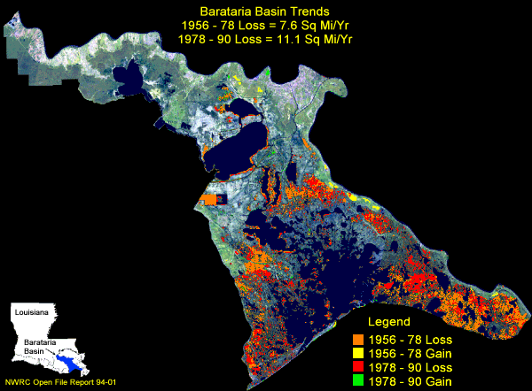
(http://www.lacoast.gov/geography/basins/ba/index.asp) From LaCost.gov
The southern, coastal, portion of the
Fresh water must be diverted back into the
Additionally, the bay side of the barrier
islands should be
restored with dredged sediment and replanted (Barataria Basin
Summary).
Dredged sediments can either be taken from river beds or neighboring
off shore
locations. Planting of native species
will yield a much faster recovery as well as preserve the ecological
dynamics
by not introducing invasive species.
Written by Sara Barnowski
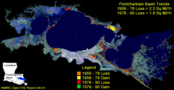
(http://www.lacoast.gov/geography/basins/po/) From LaCoast.gov
In 2002 the majority of
Pontchartrain's shoreline was eroding at a rate of at least a meter per
year,
and a southwestern segment was eroding four meters per year (USGS,
Center For
Coastal and Watershed Studies, 2006). This is especially
significant to
the land bridges between
which
act as buffers to
prevent salty water, pollution, and storm surges from entering
neighboring
lakes and reaching into other basins. Increased erosion,
development, and
natural subsidence all contribute to decreasing the area of land that
separates
the lakes and freshwater ecosystems from the ocean (Geography: Coastal
Louisiana Basins, LaCoast). This increases the rates of
salt-water intrusion
and significantly alters the ecology of the region.
Zoning laws prohibiting commercial and
residential development, along with intensive planting and
sedimentation
efforts should be implemented to prevent the further degradation of
these land
bridges.
Written by Samantha
Fox
The
Canal Regulations
Written by Leigh Casadaban
The simplest solution would be to have fewer
canals. Industry
trafficking in southern
Educate the Masses
Written by Sara Barnowski
After hurricane Katrina the people of