Written by Melinda
Medlock
There are two main parts to the problem with
the river:
- The wetlands
are dying for lack of sediment
- The
river is constantly depositing more sediment on its bed, building
itself too
high above the surrounding floodplain. This
is increasing the stress on the Old
River control
structure
and increasing
the elevation by which the river sits above New Orleans.
The following proposal is
structured around
these two parts
of the problem. The number in
parantheses next to each sub-heading indicates which of the two parts
of the
problem that section of the proposal is intended to solve.
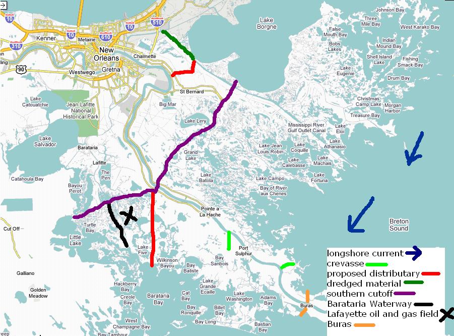
Distributaries (1)
We plan to construct two distributaries to
build up
floodplain suffering from lack of sediment. Each
will divert ¼ of the river’s discharge as
measured at Baton Rouge
USGS station during normal water levels, about 103,000 ft3
[National
Parks Service, 2004]. A flood gate at the
entry point of each distributary will control the amount of water that
is
allowed to pass into the distributary. This
gate can be opened wider during floods and partially
or completely
closed off during periods of low water. The
banks of each distributary will be armored to prevent widening of the
channel
and erosion of the surrounding wetlands. Quarried
limestone rock held in place with a wire mesh
would be most
effective and cost efficient, as limestone is mined at various
locations along
the river and could be cheaply rafted downstream.
The Mississippi River Gulf Outlet (MRGO) was
filled in with
an average of about 15 ft of silt by hurricane Katrina [Brown, 2005],
and will
be accessible only by small, shallow draft vessels until dredged. Rather than spending extra money to dredge
this channel, it should be filled in from its intersection with the
Intracoastal Waterway until the Violet Canal. This will end the funnel effect that worsened
the storm surge from hurricane Katrina. Our
eastern distributary will take advantage of the remaining channel below
this
point. We plan to widen the banks of the
existing Violet
Canal to
300ft and deepen it to 30 ft to
accommodate increased water levels. This
distributary will directly benefit the Breton Sound region.
There are currently two canals used to
access the Lafayette oil and gas field:
the Wilkinson
Canal
and the Barataria Waterway. We recommend
armoring the banks of the Barataria Waterway to prevent further erosion
of the
surrounding wetlands and establishing it as the main access canal to
the
field. Our western distributary will
take advantage of the existing Wilkinson Canal,
establishing a
uniform width of 300ft and depth of 30ft. This
distributary will directly benefit the Barataria Bay
region, which includes many lakes and large pools of water that were
formerly
wetlands. This means that the water here
is shallower than water closer to the Gulf and will fill in with
sediment
faster than areas along the coast. These
shallow pools are also more protected than areas further down the coast.
Point of Entry (1)
Currently, the point of entry to the
Mississippi river main
shipping channel is at Head of Passes, where ships can enter from the
either
the east or the west. In order to
expedite rebuilding of the wetlands by the proposed sediment
diversions, Buras should
replace Head of Passes as the main entry point to the shipping channel. Buras was chosen for the two existing canals
that connect it to the Gulf from the east and west.
Both of these canals will be widened to 500ft
and dredged to 50ft deep. Their new banks
will be armored to prevent unplanned channel expansion.
Current
Gulf
shipping channels that
end at Head of Passes will need to be extended to Buras.
This mostly involves detailing the underwater
topography of these new routes on navigation maps.
The depth of the Gulf between Buras and Head
of Passes is not large enough to require large scale dredging to move
the main
shipping routes. All levees south of Buras
should be deconstructed.
A longshore current naturally carries sand
along Gulf coast
from East to West. This current should
help distribute sediment from both diversions over a wider area,
including
areas west of the actual channel. This
current, along with constant wave action, will also begin to erode the
now
unprotected bird-foot delta south of Buras, carrying the sediment
westward into
the Barataria
Bay region.
Crevasses (1)
Two crevasses should be cut in the earthen
remains of levees
between the southern tip of Plaquemines parish and Buras.
They should be spaced five miles apart and
should speed up sediment transport to the floodplain.
Cutoff (1)
We plan a southern cutoff, below which no
people will be
allowed to live, unless on deep-water platforms like the oil companies
currently use. The main shipping channel
will be maintained until Buras with dredging or the proposed wing dams
described later. However, nothing
downriver from the Wilkinson
Canal(on the
main channel
and western distributary), or downriver of the end of Highway 46(on the
eastern
distributary) will be protected from floods. During
any period of high water, the river will overflow
its banks,
depositing sediment on the surrounding wetlands. Buras
will be no exception; it is proposed as
a checkpoint, not a port. This cutoff
will eliminate approximately 1/3 of Plaquemines parish, and the
southern tip of
St. Bernard parish. In order to give
people time to relocate, living outside the current parish boundaries
could be
disallowed immediately, and the boundary within the parish could be
enforced 50
years from now. This cutoff will allow
the river to meander and change position, the natural process which the
levees
currently inhibit.
Barrier Islands (1)
The Chandler
barrier islands should be built up using dredged material.
This material could either come from Ship
Shoal, the closer of two former delta lobes off the coast of Lousiana
where sediment deposits are shallow and easily dredged, or the
abandoned
bird-foot delta south of Buras. The
eastern distributary will also supply an increasing amount of sediment
to the
islands as the wetlands are built out into the Gulf.
The strengthened barrier islands will provide
more protection to wetlands developing as a result of the eastern
distributary
and also provide a line of defense against incoming storms. Storms have always and will continue to
regularly destroy these islands. If the
eastern distributary does not supply enough sediment to replenish them
completely
each time, dredged material may need to be supplied after major storms. Whether and how much dredged material is
needed can only be determined by continuous monitoring of the islands,
especially after a major storm hits.
Dredging (2)
The river is currently being dredged to
maintain a channel
navigable to ships with a draft of up to 45ft. This
is very costly and feasible only because of the
economic importance
of the river. The main shipping channel
should continue to be maintained by dredging while the following
proposed
solution is modeled in order to predict its effects and modify it
accordingly.
The rest of this proposal is only a
suggestion for an
experiment to model the behavior of the river when the following
changes are
made. The aim of the experiment would be
to prevent further sediment deposition along the riverbed and, at least
partially, erode the current bed down closer to the level of the
surrounding
floodplain. There are many regional and
temporal factors that affect how the river will respond to the
following
changes. Accordingly, we are
not proposing that the following
changes be implemented before their effects are tested on a model.
Wing Dams (2)
A wing dam is a structure that spans only
part of a river,
while a dam, for example, spans the entire river. Wing
dams are used to control the depth of a
river by deflecting its main channel [Mioduszewski and Maeno, 2003]. They can be used to decrease the width of the
channel, thus increasing its hydraulic radius and efficiency at
transporting
sediment. The current behind each dam
will slow and its carrying capacity will decrease.
As sediment, mostly suspended clay particles,
builds up behind the dam, it will become increasingly less porous,
building the
banks outward into the channel. This
means that the river channel will narrow and deepen.
The increased sediment carrying capacity and
pressure on the bed will increase erosion, promoting a self-scouring
process to
bring the bed level closer to the current elevation of the surrounding
floodplain. Increased erosion rates
means the existing banks, and potentially the river ends of the wing
dams will
need to be armored. This armoring is
particularly important because of the increase in velocity the wing
dams will
cause.
The wing dams should be constructed of
porous rock rubble
installed in layers. Stone of quarry-run
grade is available in mines upriver, in Illinois
for example. These rocks could be rafted
down the river at a relatively low cost. The
crest of the wing dam should be built to the surface
of the water at
normal water levels, which is about 45ft from the bed as measured from
the
middle of the shipping channel. The wing
dams will be built on the banks, so their bottoms will be sloping to
match the
existing gradient. Because they are only
built to the water’s surface during normal water levels, they will be
hard to
see during normal and low water, and impossible to see during high
water. So, each dam needs to be buoyed to
avoid
becoming a constant boat hazar
The angle that the upstream and downstream
sides of the wing
dam should make with the vertical depends on the natural repose of the
type of stone
used to build the dams. This angle for
dry materials generally increases with particle size.
(The figure below labels the angle of repose
of the stone from one quarry in Illinois [Tisdale and Richetta, 1997]). The top of the dam should be between 5 and 10
ft wide, depending on the cut of the stone laid in that particular spot. Rather than require that all the stones be
cut to exactly the same width, it is less expensive to require that all
stones
be cut to within a 5-10ft range.
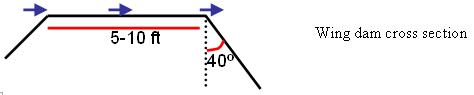
The river end of each wing
dam should make a
10-20º angle
with the vertical. The effect of a wing
dam inclined at a slight angle and one that is normal to the current
direction
is the same. The only reason to use
slightly more material and incline the dam is to reduce the impact of
the
oncoming current and limit erosion of the structure on its river end. The space allowed between successive dams
should be between 1.5 and 2.5 times the length of the upstream dam,
with a
maximum of 3000-4000ft [US Army Corps of Engineers, 1997].
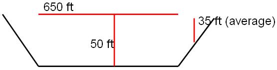
The actual lengths of the dams will vary with
the existing geography of the region. In
order to allow two-way barge traffic, the channel should have a
maintained
width of 500ft from Buras up to the Wilkinson canal, 650ft from the
Wilkinson
canal through the Port of South Louisiana, and 500ft from the Port of South
Louisiana
through Baton Rouge. (The figure below labels the proposed width
of the main channel through New
Orleans.) The
wing dams should be staggered on either side of the river to
The shipping channel from
Buras through Baton Rouge
should be maintained at a 50ft
depth because it needs to accommodate ships with a draft up to 45ft. The sloping banks depend on the geography of
the
region, but the average depth of the bed from land to the edge of the
main
shipping channel should be about 35ft. This
depth will probably be altered by the addition of the
wing dams, so
the depth profile of the river should be constantly monitored.
Modification
Estimates (2)
The following estimates of how the addition
of these wing
dams would affect the flow and sediment transport rate of the river are
based
on several basic assumptions. We assume
that the water discharge of the river is held constant, that is, the
average
annual volume of water flowing past New Orleans, does not change and
varies with the following
equation:
D = A x V
[Nelson,2006]
where D is discharge in ft3/s, A
is the average
cross-sectional area of the channel in ft2, and V is the
average
velocity of the current in ft/s. We also
assume that the sediment carrying capacity varies with the sixth power
of the
velocity [Divener, 2006]. Our
approximations for the dimensions of the current river channel at and
below New Orleans are according to the
US Army Corps of
Engineers’ report on the Mississippi
River Basin[US
Army Corps
of Engineers, 1997].
This restriction of the channel width could
potentially increase
the hydraulic radius of the river by 20%, making it more efficient.
(HRnew
- HRold) / HRold ≈ .2
The average cross-sectional area of the
river past New Orleans
should decrease
over time as the bed is eroded. This
will cause the velocity to increase. Even
a small increase in velocity translates to a large
increase in the
sediment capacity of the river, assuming the discharge of the river
remains
constant. This increase in sediment
carrying capacity means that the river could possibly carry about
150,000 tons
more sediment each day. If the banks are
armored as previously mentioned, this erosion could take place along
the
riverbed up to a rate of approximately .73ft/yr. The
riverbed will gradually erode itself back
towards sea level in New
Orleans,
where it is currently several feet above street level.
These numbers are only rough estimates; a model
needs to be built to accurately measure these benefits.
River Profile and Old River
(2)
The river bed is currently very high above
sea level all the
way out to Head of Passes, where the levees stop. The
southern cutoff (see map above) shortens
the maintained channel considerably, allowing the river to reach base
level,
sea level, sooner. This will alter the
river’s profile up through the first barrier, namely the Old River
control structure. Because it will have
a more direct route to the Gulf, our modifications to the channel
should
prevent any additional deposition and allow scouring of the existing
bed. Erosion of the bed down closer to sea
level should
decrease the height difference between the Atchafalaya and Mississippi
river beds
at the Old
River
control structure. If this does start to
happen, sediment that
has built up behind the Old River control structure should be dredged to
match
the changing elevation of the bed of the lower Mississippi. This
will decrease the strain on Old
River to maintain the
current ratio of Mississippi flow
directed down
the Atchafalaya.
It
will also increase the capacity of the structure for handling floods.
Since the mean elevation of New Orleans is
below sea level, the river
will always be at least slightly above the city and the levees
protecting the
city from river floods will always be necessary. However,
if the river does erode its bottom,
the levees would be able to handle higher and higher levels of flood
waters and
the city’s risk level for river floods would decrease accordingly.