Written by Katie
Pesce
Researched by Team 4
Many challenging factors had to be taken
into account for
our plan. The loss of the wetlands over the years
and the
rising Mississippi River are two of the biggest threats, but subsidence
and the
fact that much of New Orleans
is already below sea level also affected our solution. Our figures also
had to
be readjusted to account for global warming. In the future, global
warming will
cause sea levels to rise, which means more land loss,
and it will also cause increasingly powerful hurricanes from the Atlantic, which means more powerful storm surges
and
flood waters. We also looked at the possible environmental effects of
our plan
because we didn’t want to greatly imbalance any ecosystem.
Many of the levee failures were human error
and bad engineering design,
which can
be fixed by careful design, construction, and maintenance. The New Orleans
flood protection system was not
built cohesively as one uniform system. It was built in phases and
stages by
many different groups. We emphasize the importance of standardizing the
construction, monitoring, and maintenance of the system.
Short
Term Fixes
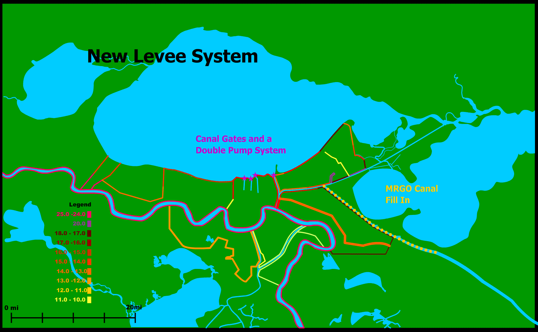
Closing off the
Mississippi River Gulf Outlet
Written by Team 9
We are planning to create two main
distributaries
leading to the east and west of the current channel of the Mississippi River. These distributaries
would deposit sediment in the
surrounding wetlands to help revitalize them. The eastern
distributary
channel will utilize the current Mississippi River Gulf Outlet
(MR-GO).
This channel was filled in with an average of about 15 ft of silt by
hurricane
Katrina and is accessible only by small, shallow draft vessels until
dredged
(Brown 2005). Rather than spending extra money to dredge this
channel, it
should be filled in from its intersection with the Intracoastal
Waterway until
the southern tip of Lake
Borgne. The
funnel effect
during Hurricane Katrina that flooded much of New Orleans East and St.
Bernard
Parish and ultimately caused levee breaches along the Industrial Canal
initially came up through MR-GO. Closing of MR-GO would end the funnel
effect
that
worsened the storm surge from hurricane Katrina. A distributary from
the Mississippi river should be
directed into the remaining
lower section of the MR-GO. This distributary will redirect a
maximum ¼
of the river’s volume, or about 103,000 ft3 of water during
normal
water levels (General Information About the Mississippi River).
The intersection of the previous MR-GO channel and the new distributary
will be
marked by a flood gate that will control the amount of water allowed to
enter
the channel. This way, during periods of low water, more of the
river’s
volume can be kept in the main channel to ensure a navigable channel
for
ships.
The impact on the industry and shipping of New Orleans
should not be very great. Usually
the MR-GO is used by commercial ships as a short cut from the ocean to
the port of New Orleans,
but closing it off will only add about 40 miles into Lake Pontchartrain to their journey. The
security from preventing
another funnel effect by closing off the MR-GO greatly outweighs the
frustration caused to any industry.
Canal Gates and Double Pumps
Unfortunately the very same canals that have successfully
drained New Orleans
for many years
were the cause of much of the flooding in Northern parts of the city.
The
pumps were unable to pump water out
of the city because they
were situated below sea level and their power source gave out. As a
result, the levees
along the
canals failed and the water was free to flood the city (IPET).
To solve this problem we propose installing strong gates at
the front of the 17th
Street , London
Avenue, and
New Orleans
Avenue Canals. They would basically be single sluice gates that slide
vertically. This has actually already been implemented in New Orleans
since Katrina.
Temporary gates are in place
already with plans to put in permanent ones. These gates will remain
open most
of the time to allow the canals to serve their usual function of
draining the
city, but when there is the threat of a storm surge, the gates would be
closed
to prevent water from pouring into the canals and putting pressure on
the
floodwalls and levees. Pipes on both sides of the floodgates will allow
the
pumps to continue draining the city of water even though the gates are
closed
(USACE Hurricane Protection System Improvements).
The governance of the flood gates would be
given to NOAA (National Oceanic and Atmospheric Administration). This
federal
agency is in charge of providing “data and forecasts for weather and
water
cycle events, including storms, droughts and floods” (NOAA). The agency
would
watch the weather forecasts for the Gulf Region and alert the city of New Orleans when a threatening storm surge or
water level
is present in Lake Pontchartrain .
The gates
would be closed and remain closed until the water level subsided.
There is currently work in New Orleans to rebuild the pumping
stations and increase
their capacity. The pumps are designed to drain the city of water. They
were
not built to operate during hurricanes (USACE). To fix this problem we
propose
implementing a double pump system, in which pumping stations are
present at
both the lake shore and in the interior of the city where the canal
ends. This
would increase the pumping capacity and redesign the pumping system so
that it
could
handle both normal drainage and hurricane floods.
For all the pump stations in general around New Orleans , we
will install back-up power
generators and raise all the critical equipment three feet off the
ground to
help
insure that they will continue working when the flood rate surpasses
their
pumping rate (USACE Hurricane Protection System Improvements).
Levee
Re-Construction
The engineering failures and inadequate heights of the levees
were major
factors that caused the flooding of the city. The levee system in the New Orleans area
includes
about 450 miles of levees. The map above shows the heights to which we
plan to
build the levees or maintain them. We plan on leaving all the levees
that the Army Corps has already reconstructed, which include the levees
along Lake Pontchartrain and in New Orleans East. All the levees
will be built up to withstand a Category 5 Hurricane. We are also
lengthening the levee in Jefferson Parish south of the Mississippi
River so
that it
extends all the way in the west to the Mississippi
River.
Among our improvements are replacing all I-walls with T-walls.
I-walls are located in
many places including in the 17th Street Canal and London Avenue Canal
levees and along
the Ninth Ward. T-walls are much more structurally sound. They are
less
likely to be pushed over because of their wider, heavier foundations
(ASCE
Instrumentation of Embankment Dams and Levees). Floodwalls are rated
according
to a factor of safety. They should have a factor of safety of 1.3,
meaning that
they are 33% stronger than they need to be to deal with the water
pressure.
However, the 17th Street Canal levees had only a
factor of
safety of 1, so there was little question that they would fail (NPR).
To protect against subsidence, we have our maintenance and
monitoring
program that will be described later. We will also look at the
subsidence rates
at each individual levee site on a small scale. Part of the previous
problem
was that the Army Corps took the average of the subsidence rate along
very long
lengths of levees. This system puts the whole levee in danger because
it
disregards very extreme, dangerous subsidence rates (NPR). From now on,
however, subsidence rates will be dealt with on an individual basis,
instead of
averages.
Poor soil quality was another huge issue. The 17th Street
Canal levees were built
on top of sand that caused the foundations to be unstable. Also, many
of the
floodwalls were anchored in soft clay, allowing rising water to push
the wall
horizontally and a gap to form at the base of the floodwall and failure
from
spreading to occur. If the quality of the soil is poor at the locations
of the
levees, we will replace it with suitable, compacted soil. Although this
is an
expensive solution, it is the only way to ensure the stability of the
levees
and floodwalls. Extensive evaluation of the geology of the levee
locations is
essential (IPET).
To protect against erosion from the levees along the 17th Street, Orleans
Avenue, and London Avenue Canals
and the Industrial
Canal will
be armored
with concrete on the backside so that overtopping will not erode the
backside
of the levee and cause a levee failure. They will also be armored on
the
water-side of the levee at the base of floodwalls so that gaps can’t
form at
the between the base of the floodwalls and the soil. Transition points,
for example
between floodwalls and levees, would be armored because during
Hurricane
Katrina those spots proved especially vulnerable (USACE Hurricane
Protection
System Improvements).
Levee Maintenaince
and Monitor
Boards
Levee Management –
The Levee Board
The current, ineffective levee board system
in New Orleans
is partly what
led to the levee failures. The levees are controlled by local levee
boards, and
there is little interaction or communication between them. The safety
standards
vary greatly from district to district, and there was no set plan for
the
maintenance of the levee system. The levee boards are also involved in
many
other interests, such as real estate and economic ventures. This also
causes
corruption to be a hindering factor in the levee boards (Eichenseher).
We plan to consolidate the levee boards into
one body in
which each district would be represented. The Levee Governance
Board would
be in charge of overseeing the rebuilding of the levees to and their
maintenance at the specifications and standards we set up earlier. The
members
of the board would be appointed by the governor and it would include
engineers
of technical expertise. All the land currently held by the levee boards
would
be property of the state. The Levee Governance Board would be
responsible for
the safety and upkeep of the levee system and would have to report to
the
governor on its activities and budget.
The National Levee
Safety Program Act of 2006 is a bill in Congress that sets up standards and protocol for the
inspection and inventory of the levees, an interagency committee on
levee
safety with a National Levee Safety Advisory Board, and a National
levee safety
program (H.R.4650 National Levee Safety Program Act of
2006). This is obviously a very important measure
that will not only help ensure the safety of New Orleans, but many other port
cities as
well.
Monitoring and
Maintenance
Written by Dan Beauboeuf
The levee system pre-Hurricane Katrina had
been very poorly
maintained. Because of subsidence many of the levees had sunk below
where they were
supposed to be, and the levee heights are extremely inconsistent from
region to
region (IPET). As mentioned above, the Levee Governance Board would be
in
charge of overseeing all levee maintenance.
The Board would require a yearly inventory
of the levee
system. Any damage that is found would be fixed according to safety
priority
before the next hurricane season, or if on the river before the next
high
water. Subsidence would be taken into account every year by raising the
levees
to account for unacceptable height loss.
Part of ensuring the safety of the levees is
informing and
involving the community and making sure that they don’t get complacent.
One way
in which we plan to do this is by involving the local universities,
such as
Tulane and University
of New Orleans,
in the
levee monitoring program and research.
Lack of
knowledge
about the state of levees protecting New Orleans was a major reason for
failure. Subsidence had changed the
heights of levees
in the city by feet in certain neighborhoods (IPET).
To have a more systematic approach to levee
monitoring, we
are going to put electronic sensors in all the levees. Our plan
includes the
use of a Differential Global Positioning System that will monitor the
relative
positions of points along the levee system. The
DGPS system recommended by the United States Army
Corps of Engineers
for Levees and Groins has a horizontal movement tolerance of 1-2 ft.
and a
vertical tolerance of .5-1 ft. We believe that this level of accuracy
is not
precise enough to protect New
Orleans. The levee
system protecting New Orleans
needs to be much more closely
monitored. We suggest using equipment
with Feature Position Tolerance approaching that used in structure site
plans. Such sensors have horizontal
tolerances of .01-.5 ft. and vertical tolerances of .01-.5 ft. Operating with smaller tolerances would allow
for engineers to detect the deformation of levees sooner (Engineering
Manual). The
readings will be transmitted by satellite to monitoring stations at the
local
universities. This system will be useful in the overall maintenance of
the
levees and for emergencies. If people at the monitoring stations see
that a levee is in danger of being breached, they could inform the
Levee Governance Board who could
then
evacuate areas in danger.
A side benefit to the improved monitoring
and maintenance of
the New Orleans
levees is all the skilled, well-paying jobs it will create. The
maintenance of
the levees will be a year-round task that will require a constant crew
of
workers.
One of the lessons learned after
Hurricane Katrina was that proper maintenance and monitoring is
imperative to
public safety. We envision the
monitoring system to be the first step in a levee maintenance program. The decision to use small tolerances in our
system was made keeping in mind the various subsidence rates throughout
the
city. The fear is that some of the
highest subsidence rates per year (6-10mm per year) are not larger than
the
tolerances of the USACE specified sensors. Therefore,
there was the danger of waiting years before
being able to
conclusively verify problems. With the
smaller tolerance engineers will be notified much sooner of issues. We suggest that after such notification, that
the levees in question be surveyed and adjusted as needed.
Army
Corps
The Army Corps has already hired contractors
to rebuild the flood protection system, but the Corp needs to be
present in the process to guarantee the levees are built up to the
Levee Governance Board specifications. The Army Corps needs to
receive updates from the monitoring system. They are presently
understaffed and underfunded. Many reports have surfaced saying
the
Army Corps had not built the levees up to the standards of the
projected plans
and had done an extremely inadequate job maintaining the levee system
(Bordeau).
The Corps knew that the flood protection system in place would not hold
up to a
strong storm (Shwartz). Misinformation was also rampant. The steel
pilings in
the 1 7th St.
Canal levee should have been 15-30 feet deep according to the
records of
the Army Corps; however, they were only a few feet deep (IPET). The
Army Corps
of Engineers needs to be held accountable for its failures in
protecting New Orleans.
Timeline
|
As
of Nov 2006
|
Temporary
flood gates on canals 220
miles of levees have already been repaired.
|
|
Sept
2007
|
All
undamaged floodwalls and levees raised to approved heights and all
floodwall engineering errors fixed.
|
|
2010
|
Flood
Protection System will be complete and meet the 100-year certification.
|
Interim Plan
It will
take some time before the whole of the flood
protection plan will be completed. Obviously, this leaves the city at
some risk
during the coming hurricane seasons. In the meantime, temporary flood
gates
have been put across the 17th
Street, London
Ave,
and Orleans Ave
canals. Many of the most essential levee breaches have already been
repaired.
But the main emergency measure that should be taken when floods are
threatening
is a stricter evacuation plan. When a hurricane is coming close to New
Orleans
or the river is rising too swiftly, people need to be mandated to
evacuate much
sooner than if the flood protection system was in full operation. Our
first
priority is the safety of the people.