
| ||||||||||||||||||||||||||||||||||||
Groundwater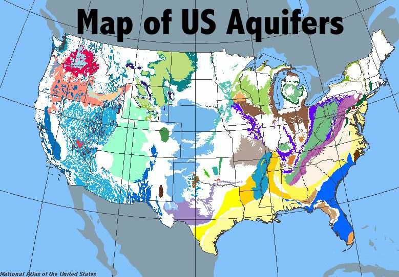
Above is a map of all groundwater supplies in the United States. The light blue section in the center of the map spanning the majority of the United States from South Dakota to Texas is the Ogallala Aquifer. Map Maker. (n.d.). Retrieved November 15, 2008, from National Atlas: US Geological Survey: www-atlas.usgs.gov
Main ProblemsThe main issues regarding groundwater in the Western half of the United States are that:
In the following sections, we will discuss each of these problems in more depth using the Ogallala Aquifer as a case study. However, these problems can be identified in most all groundwater in the Western half of the United States (Schlager, E. 2006). Background on the Ogallala AquiferThe Ogallala Aquifer, the largest aquifer in the Western North American Region, is hosted in sedimentary rocks that were deposited in the Pliocene and Miocene geological time period which started 24 million years ago and ended 1.8 million years ago. Sand and gravel eroded from the uplift of the Rocky Mountains, were transported eastward by large river systems, and blanketed the landscape. These highly porous and permeable sands and gravels filled with water during times of much wetter climates such as ca 10,000 years ago. The Ogallala Aquifer covers approximately 174,000 square miles (about 450,000 km2) (U.S. Geological Survey, 2008) and lies under Colorado, Kansas, Nebraska, New Mexico, Oklahoma, South Dakota, Texas, and Wyoming. Currently, its thickness varies from less than 1 ft to about 400 ft (Miller, J. & Appel, C., 1997). Since recharge rates are so slow, if the Ogallala Aquifer is completely depleted, it will not refill itself in a matter of years. Groundwater is not like a river that is constantly flowing and bringing new water, it is instead a collection of water, mostly ancient water from glaciers, held under ground for millions of years that will take an extremely long time to refill once depleted. 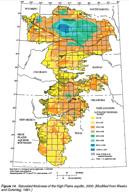
This image depicts the saturated thickness of the Ogallala Aquifer. Its saturated thickness is largest in Nebraska, and smallest around Texas. This is a problem because of the extensive dependence Texas' agriculture has on groundwater. 30% of irrigation water used in Texas alone comes from groundwater (Kromm, 2007). McGuire,V.L., Johnson, M.R., Scheiffer, R.L., Stanton, J.S. , Sebree, S.K. , & Verstraeten, I.M. Water in Storage and Approaches to Groundwater Management, High Plains Aquifer, 2000. (2004) U.S Department of the Interior and US Geological Survey. Circular 1243 pp 24. The Ogallala Aquifer is a vital source of water since it supplies 81% of the water used in the High Plains area. The remaining 19% of water comes from surface water (U.S. Geological Survey, 2008). Most of this groundwater is used in irrigation since 54% of the land within the Ogallala Aquifer region is used for agriculture. This land accounts for 27% of the nation's irrigated land and is responsible for 19% of the nation's wheat, 19% of its cotton, 15% of its corn, and 3% of its sorghum. However, with such a great production from the Ogallala Aquifer region comes just as great a cost in water (U.S. Geological Survey, 2008). RechargeHow Much is Actually Recharged?Annual recharge of the Ogallala Aquifer varies widely from region to region; however, the average annual recharge rate is .85 in/year, or 21.59 mm/year (U.S. Geological Survey, 1966). For example, recharge rates in Nebraska can vary from 15.24 mm/year to 60.96 mm/year (McMahon, P.B., B?hlke, J.K., and Carney, C.P., 2007, 9). All of these numbers are minuscule when compared to the amount of water being produced from the Ogallala Aquifer each year, leading to a net overdraft rate, or net rate of groundwater mining, of 54.864 mm/year averaged, area-weighted, across the entire aquifer (McGuire, 2007). This gap in recharge and discharge must be addressed and changed before the Ogallala Aquifer is exhausted. In order to understand the problems regarding the Ogallala Aquifer and its depletion, it is necessary to understand recharge. What Causes RechargeThe Ogallala Aquifer is recharged mainly through precipitation in the spring and summer months (Fryar, Mullican, and Macko, 2001, 534). On average, 350 mm (13.8 in) of rain falls in the southwest part of the Ogallala aquifer annually. Up to 500 mm (19.7 in) of rainwater falls annually in the northeastern part of the Ogallala. However, evapotranspiration is at its peak in the spring and summer months when most precipitation occurs, so only a small percentage of this rainfall actually reaches the aquifer (Nativ, 1992, 26). Most of the recharge due to precipitation occurs during snowfall and rainstorms (S. G. Robson and E. R. Banta, 1995). Irrigation canal leakage in Kearny and Finney Counties in Kansas is also a source of recharge. As much as 15% of irrigation water can permeate into the Ogallala Aquifer (Kansas Department of Agriculture, 2006). Additional sources of recharge include industrial wastewater, treated sewage, and storm water. All three of these water sources flow into the Ogallala Aquifer through a series of ditches (Fryar, Mullican, and Macko, 2001, 533). Recharge from riverbeds is also a minor source of water for the Ogallala Aquifer (Miller, J. & Appel, C., 1997). In addition, playa lakes provide an important additional source of water. Playa lakes form in closed drainage basins and are seasonal lakes formed from rainwater or from groundwater seeping up to the surface (EPA, 2008). Because they lack any outlets, the water either seeps into the underlying aquifers or evaporates. Some of these playa lakes leave distinctive saline deposits (EPA, 2008). There are many of these in the Southern High Plains, especially in West Texas, Oklahoma, and New Mexico (EPA, 2008). Research indicates that playa lakes are a major source of recharge for the Ogallala Aquifer. Shrinkage cracks in the clay floor of these lakes and solution channels in the caliche, which is a layering that normally prevents recharge, provide a pathway for water to seep deeper into the ground and ultimately reach the Ogallala aquifer (Nativ, 1992, 27). While there are many sources recharging the Ogallala Aquifer, each source only contributes a small amount of water. What Prevents RechargeThe main barrier to recharging the Ogallala Aquifer is lack of permeability. Fine grained soil, like the soil found in the northern Texas Panhandle, is less permeable than larger grained soil. In arid environments, like that underlain by the Ogallala aquifer, high evaporation rates result in soil carbonate or caliche that forms at the surface and acts as a recharge barrier due to its impermeability (Nativ, 1992, 26). Both of these factors, fine grained soil and caliche, hinder recharge to the Ogallala Aquifer since they decrease permeability and porosity, allowing most water to evaporate. Although rain falls on average 14 to 20 inches per year, evapotranspiration rates range from 60 to 105 inches per year (S. G. Robson and E. R. Banta, 1995). This high evaporation rate diminishes natural recharge. So while there are many sources of recharge, discussed above, all contributing a small amount of water, there are two main natural barriers to recharge: lack of ground permeability and high evaporation rates. While these are significant, manmade depletion is a much larger cause of aquifer depletion, and will be discussed in the next section. DepletionHow Much is Actually Depleted?The main problem with groundwater in the Western Northern American Region of the world is that water is being withdrawn from aquifers at a rate much greater than the recharge rate. Specifically, the Ogallala Aquifer is being recharged at a rate of approximately 22 - 25 mm/year (Kromm, 2007) (U.S. Geological Survey, 1966) and experiencing net overdraft of 54.864 mm/year (McGuire, 2007). This will lead to ultimate depletion of the Ogallala Aquifer. As of 2005, the cumulative decrease in average saturated thickness of the aquifer since predevelopment was 390.144 cm, area-weighted (McGuire, 2007). Below is a graph from the USGS, compiled in 2000, that outlines the change in volume of water stored in the Ogallala Aquifer from predevelopment to 2000. Everything is measured in million acre-feet. To put these numbers into perspective, the USGS estimates that the total amount of water in storage was 2,980 million acre-feet in 2000. However, only 60-80% is actually available for large scale pumping and the amount of water in storage per state ranges from 40 million acre feet (New Mexico) to 2000 million acre feet (Nebraska) (McGuire et al, 2000, 25). This graph clearly shows that the Ogallala Aquifer is being depleted, and if nothing is done to change current water pumping behavior, the Ogallala Aquifer will become extinct. TABLE 1
McGuire,V.L., Johnson, M.R., Scheiffer, R.L., Stanton, J.S. , Sebree, S.K. , & Verstraeten, I.M. Water in Storage and Approaches to Groundwater Management, High Plains Aquifer, 2000. (2004) U.S Department of the Interior and US Geological Survey. Circular 1243 pp 32.
The withdrawal rate of water from the Ogallala Aquifer is much too high to be sustainable for the next one hundred years. At current rates, the aquifer will soon be depleted, endangering the current Western United States agricultural economy. Thus, we must reduce the United States' overdependence on the Ogallala's water by reducing the water usage within the Ogallala's boundaries. Where the Water GoesWater from the Ogallala Aquifer is used mainly for irrigation and evapotranspiration (S. G. Robson and E. R. Banta, 1995). Water drawn from the Ogallala supplies agricultural, domestic, industrial, mining, and livestock needs. Ninety-four percent of the total groundwater usage from the Ogallala is for irrigation. This sums to about 15,745 millions of gallons per day of water usage for irrigation from the Ogallala alone, and 30% of all groundwater used for irrigation in the United States. The 2.5% taken for domestic drinking water as well as the amounts taken for mining, livestock, and industry (1.3%, 1.3%, and .9% respectively) are small in comparison (U.S. Geological Survey, 2008). Nebraska, Texas, and Kansas use the highest percentage of groundwater for their irrigation (46%, 30%, and 14% respectively) (Kromm, 2007). For more information about irrigation please visit the Irrigation Problem Section. ContaminationHalf of the United States population and 97% of rural residents depend on groundwater for their daily drinking water (National Groundwater Association, 1988). Currently, the water quality is generally acceptable, but as more pollutants seep into the water supply over time, contaminated water will have serious detrimental effects on human health and ecosystems. To prevent such damages, we must begin by examining the sources of contamination. Sources of Contamination: Point Sources and Non-Point SourcesManmade sources may be characterized as point sources, where the contaminants can be traced to a particular location, and non-point sources, where contaminants accumulate over a large, more vaguely defined area. Point source problems are likely the easiest of the two categories to be solved. Examples of point sources include leaky tanks or pipelines containing petroleum products, septic systems and industrial waste (Environment Canada, 2008). Leaks from old storage tanks and septic systems include bacteria, oils, and chemicals. Motor fuel contains hydrocarbons and additives that pose health risks to people, animals, and plants. In 1994, it was estimated that 1.2 million Underground Storage Tanks (USTs) existed in the U.S., many of which could be leaking or leak at some time in the future (Water Environment Federation, 4-108). Local gasoline stations use, by far, the largest number of USTs. Most of them have two to four 4,000 to 12,000 gallon tanks underground. Some rural homeowners may also use USTs for residential or farming purposes. Landfills allow waste from households and domestic uses to permeate into the aquifers. It is estimated that over 30,000 potentially harmful chemicals are being used and distributed through the environment and that an additional 1,000 are being added each year (Geophysics Study Committee, 1984, 24). Currently, there are thought to be over 20,000 abandoned and uncontrolled hazardous waste sites in the United States alone and that number grows every year (The Groundwater Foundation Website, 2008). The second type of source includes runoffs from urban development, roads/highways, and agricultural uses of fertilizers and pesticides. These sources are much more difficult to control because the contaminants are diffused over a large area. Most Harmful SourcesThe most serious source of contamination is in recharge zones and consists of petroleum products, including automobile oil, which Americans dump or bury in their backyards at the rate of 240 million gallons (910 million L) per year. On a more industrial scale (factories), inadequately sealed toxic waste and radioactive materials contaminate extensive areas of groundwater when they are deposited near recharge zones (Batu, 1998). We must control the pollution of groundwater to preserve our current quality of freshwater. Water quality differs by region. The table below classifies the watersheds in the United States by current water quality and susceptibility to further contamination. The United States contains portions of 2262 watersheds, as shown in Table 2. TABLE 2
(Summary of EPA Watershed Indicators. Scorecard: The Pollution Information Site. Retrieved from http://www.scorecard.org)
Environmental Effects of Groundwater DepletionGroundwater provides a natural buffer against drastic changes in precipitation. During times of drought and dry seasons, when there is hardly any surface water available for plants, groundwater is an invaluable resource. It is a source of quality water, due to the natural filtration process through the porous or semi-porous rock/soil layer above the aquifer and provides invaluable nutrients for the ecosystem. Groundwater is a contributing source for many streams, rivers, and creeks (Bergkamp et al.). Ecosystems that Depend on GroundwaterDue to the wide range of groundwater's role in an ecosystem, depletion of groundwater can be detrimental to the environment. There are several ecosystems that depend on groundwater, such as estuaries, wetlands, and riparian ecosystems. Riparian ecosystems are land ecosystems found near moving water bodies, such as rivers and streams. Riparian ecosystems are generally found in the semi-arid or arid environments. They rely heavily on groundwater to tide over a dry season. Groundwater may directly provide water to the system, or it might indirectly be the source of the water through its natural discharge into streams and creeks (Bergkamp et al.). Riparian ecosystems are rich ecosystems that host a wide variety of species. For example, in Arizona 60-75% of all species depend on the riparian environment in some point in their life ("A Vision for Riparian Protection"). If these ecosystems become too polluted and are no longer able to sustain life, due to lowered water table, it would drastically affect numerous species, greatly reducing biodiversity. Native species are extremely sensitive to changes in the water table. Another ecosystem that heavily depends on the condition of the aquifer, is the aquifer ecosystem. It has recently been shown that aquifer ecosystems host a wide variety of un-discovered species. Aquifer ecosystems, which had once been thought of as devoid of life, due to their secluded location, have been shown to host a variety of species. Due to the lack of research and studies on such ecosystems, we are still unable to determine the effects of groundwater depletion and contamination on these ecosystems. In addition, these species have been found to be unevolved for nearly 200 million years (Australian government: National Water Commission, 2008). These "living fossils" may provide a clue to the world 200 million years, and present itself as an invaluable resource (Australian government: National Water Commission, 2008). On a microscopic level in these aquifer ecosystems, microbes and bacteria are able to disintegrate contaminants into nutrient and energy for the ecosystem. (NSW Government: Department of Land and Water Conservation, 2002) Therefore, these microbes and bacteria serve an essential role in the ecosystem, in reducing contaminants and providing the primary source of energy for the ecosystem. All these species and life forms are dependent on groundwater. (Bergkamp et al.). Wetlands and estuaries both depend on groundwater to control the salinity and provide nutrients to the ecosystem. Any drastic changes in the condition of the groundwater can result in the loss of these habitats. Effects of OverpumpingSince the 19th century, with the advent of electric pumping, there has been an increased exploitation of groundwater resources. This over pumping of groundwater has led to a drastic drop in groundwater levels in the aquifers, hurting fragile ecosystems. This depletion can drastically affect the rivers and streams. It turned once perennial rivers into ephemeral. (Stromberg et al., 1996, 113-131). This sudden decrease threatened the riparian ecosystem. Usually, the first species to be affected by this drop in groundwater levels are the water-sensitive plants, like some wetland and riparian plants. Younger plants are also generally more affected by the lack of groundwater than the older plants. (Stromberg et al., 1996, 113-131). Plants, such as juvenile Salix Gooddingii, juvenile Populus Fremontii, juvenile Fraxinus Velutina, only have a range of about 1.8m change in depth to groundwater. This means that if the water table decreases by more than 1.9m from the surface, these plants will not be able to survive (Stromberg et al., 1996, 113-131). Currently, in Ogallala Aquifer, it has been shown that in some parts since pre-development the water table has dropped more than 150 ft, the equivalent of 45m. (McGuire et al., 2004). Hence, in areas around the Ogallala Aquifer, such riparian ecosystems have already been destroyed. Similar conditions have been observed throughout the Western US. Since these species have such a narrow range of tolerance for water table changes, any decrease in water table can result in a decrease in biodiversity of the ecosystem. Most of the species in these ecosystems are unique to the ecosystems. For example, mangroves are found only in wetlands, while certain invertebrates can only be found in aquifer ecosystems. (Australian government: National Water Commission, 2008). In addition, as groundwater levels decrease and native species begin to die, new exotic, non-native species will begin to invade into the ecosystem. These invasive species have a higher tolerance for the decrease in groundwater and can better adapt to this environment. However, this invasion by exotic species greatly decreases the biodiversity of the ecosystem (Stromberg et al., 1996, 113-131). In addition, with the boom of the agriculture industry and urban growth, there are increased amounts of agricultural run-off that is high in nutrient content. When this run-off drains into the groundwater and subsequently enters into the wetlands and estuaries, it can cause eutrophication of the ecosystem. This greatly threatens the health of the ecosystem, as there is a significant reduction in oxygen and an increase of carbon dioxide in the system. In addition to agricultural run-off, another significant issue is industrial waste that inadvertently ends up in such ecosystems. Many of these ecosystems are also considered as the natural filtration system of the region. Hence, usually many of the contaminants end up in these ecosystems, harming the wildlife and the habitat. Thus, overpumping groundwater and contamination from agricultural run-off has threatened the existence of these delicate systems. Current Policies in PlaceAlthough there are numerous federal agencies already in place, committed to restoring, maintaining and conserving ecosystems, many of these programs have only an "adequate" rating. "Adequate" is the lowest performing rating given to federal programs ("How we Rate Programs"). In addition, these 14 different federal programs have overlaps and have limitations. For details on the federal programs, please refer to the Public Policy Section. To streamline these programs, a new system should be implemented to unify these programs. By unifying these programs, they are able to consolidate their information, resources and strengths to improve on aspects, such as monitoring aquifer condition. Current Public Policy Regarding GroundwaterState Policies For Groundwater WithdrawalsPresently, policies regarding groundwater are implemented on a state by state basis, and are highly variable. Some set specific depletion caps, others only say that water must go to "beneficial uses". Many but not all states require permits for drilling and producing from wells; generally, wells for domestic purposes do not require a permit and go primarily unregulated. Outlined below is each state's current approach to groundwater management.
ColoradoIn Colorado, one must obtain a permit to use groundwater. Water permits are considered property rights and can be bought and sold independently of the land upon which the well rests. The governing body for groundwater issues is The Colorado Ground Water Commission. This commission is in charge of issuing and changing water permits. In addition, the Colorado Ground Water Commission divided the groundwater in Colorado into two districts: the Northern High Plains Designated Basin and the Southern High Plains Designated Basin. These districts can put additional rules regarding groundwater management into place; however they cannot issue permits. Only the Colorado Ground Water Commission can issue or change permits. Since 1990 permits have been issued with the policy that no permit will be issued for a new well if it is projected that that well will deplete the aquifer within a 3-mile radius by 40% within 100 years. Also, since 1967 new large-capacity well permits will not be issued if they are closer than 0.5 miles from an existing large-capacity well drawing from the same aquifer. To change a permit "requires that the well be limited to the average annual historical consumptive use and proof that no material injury will occur to other vested water rights" (McGuire et al, 2000, 37). Changing permits is difficult because most new proposals fail the less than 40% depletion in 100 years criteria mentioned above. (McGuire et al, 2000, 37) KansasIn Kansas, anyone with a permit or a vested right can use groundwater for nondomestic purposes. A vested right means that that well had been pumping water since June 28, 1945 and therefore has a right to continue pumping; however, water pumping for domestic purposes is not regulated by permits. In all cases, a landowner must "use the water for beneficial purposes" (McGuire et al, 2000, 39). The governing bodies for groundwater in Kansas are the five Groundwater-Management Districts. These districts are in charge of regulating nondomestic water use and they can propose regulations that do not conflict with state law. Of these governing bodies some follow the idea of "safe yield" and others follow the idea of "allowable depletion". "Safe yield" is the concept that total groundwater withdrawal in their district must be a certain percentage of the aquifer recharge in that radius. "Allowable depletion" is the concept that total groundwater withdrawal in their district must not deplete the aquifer in that radius by more than a specific amount in a specific time (McGuire et al, 2000, 39). NebraskaIn Nebraska, one has the right to use "a reasonable amount of the ground water under their land for beneficial use on that land"(McGuire et al, 2000, 40). The Nebraska Department of Natural Resources (NDNR) is in charge of groundwater withdrawals. The NDNR is divided into 23 Natural Resource Districts (NRDs) which each have the authority to manage groundwater use. Each NRD must have a ground-water-management-plan, approved by the NDNR, which outlines what they will do to manage depletion and quality concerns in their area. NRDs are also in charge of distributing well permits, which are required for all wells constructed after September 1993 except for those "used exclusively for domestic purposes and for test holes and dewatering wells used for less than 90 days" (McGuire et al, 2000, 40). In areas where there is not NDNR governance, residents follow the Nebraska correlative rights doctrine that states that residents must share when groundwater supplies are limiting (McGuire et al, 2000, 40). New MexicoIn New Mexico, water rights are based on the prior appropriation doctrine. There are six groundwater basins all governed by the State Engineer. The State Engineer has the authority to grant permits. In general, the State Engineer approves most permits for domestic use. For nondomestic use, however, the State Engineer will approve permits only if these 4 criteria are met: "(1) no objections are filed, (2) unappropriated water exists in the basin, (3) no infringement on the water rights of prior appropriators occurs, and (4) it is not detrimental to the public welfare or the water conservation goals of the State" (McGuire et al, 2000, 41). The State Engineer determines the validity of criteria 2 by monitoring the groundwater levels 9 to 25 miles around a proposed well site. If water levels decrease by 2.5 feet in one year then the well does not receive a permit. In addition, water rights are bought and sold independently of the land upon which the well sits. As long as the State Engineer approves, water rights can be sold for out-of-state use (McGuire et al, 2000, 41). OklahomaOklahoma management policy is based on the reasonable use doctrine. Licenses, granted by the Oklahoma Water Resources Board (OWRB), are needed to withdraw water from the aquifer. The amount of water withdrawn is determined by the OWRB and varies from region to region. This amount is determined by the maximum amount of water that can be withdrawn and still secure the availability of water at least 20 years from the time of the license; hence, the specific amount of water is uniquely calculated for each region. This amount is adjusted yearly when each license holder must check in with the OWRB and report how much water they pumped and set limits for the amount of water allowed for the next year. (McGuire et al, 2000, 42). South DakotaSouth Dakota's water resources are managed by the South Dakota Department of Environment and Natural Resources (SDDENR). The Water Management Board (WMB), a group of citizens, works with the SDDENR to manage groundwater. South Dakota law says that all water is a public resource. However, water can be withdrawn once a permit has been approved. The state also sets a specified amount of water that can be withdrawn. Generally, the amount of water withdrawn does not exceed the natural recharge rate. All permits, other than irrigation permits, can be transferred to out-of-state. Most of the groundwater is found below the Rosebud Indian Reservation land. Hence, these tribes have pre-dominant control over the use and development of the groundwater (McGuire et al, 2000, 43). WyomingWyoming management policy is based on prior appropriation. Wyoming law mandates that all natural waters are property of the state. Permits are given out to users, given that beneficial use is demonstrated. There is no specific limit on the amount of water that can be withdrawn. If the user would like to change any aspect of the permit, the user must first appeal to the state. No permits are needed if the out-of-state transfer is less than 1,000 acre-feet per year (McGuire et al, 2000, 45). TexasTexas regards groundwater that is still in the aquifer as a public resource. However, once the groundwater is withdrawn, it is specific to the landowner. Groundwater can be sold to other locations, including out-of-state. No landowner can purposefully withdrawal groundwater for "malicious reasons or to willfully waste the water". Groundwater in the Groundwater Conservation District can regulate the withdrawal, by regulating the permits. No permits are needed for wells that withdrawal less than 25,000 gallons per day or for domestic/livestock wells (McGuire et al, 2000, 44). CaliforniaIn California, there are currently three types of water rights that are given out. There are riparian rights, appropriative rights, pueblo rights. The water itself is considered the property of the State, however the water right entitles the user to withdraw water from the source for beneficial use. Water rights are considered as property and hence can be sold and transferred between individuals and/or parties. Riparian rights are generally senior to other rights and are incurred by owning property that borders a water body, such as streams, lakes or ponds. Riparian rights allow the owner to use the water from such sources for beneficial uses without any permits. On the other hand, appropriative rights are designated for surface water being used for beneficial uses. One must file an application, in order to acquire appropriative rights. Pueblo rights apply to both surface and subsurface water source and the entire watershed. Hence, the amount of available water for beneficial use, under pueblo rights, increases with population and urban growth. In California, groundwater provides 30% of the water source. However, there are no current permit application procedures for groundwater use. California only mandates that all owners of land above the aquifer share the right to the "reasonable use" of the aquifer (Water Rights Fact Sheet, 2001). OregonGroundwater in Oregon is considered property of the state and one must obtain a permit to pump groundwater. One will not be granted a permit if the proposed well will interfere with existing wells or surface water use. Oregon declares an area a Critical Groundwater Area if the depletion rate exceeds the recharge rate; currently there are six such areas. Within these areas groundwater use is restricted and certain users have priority, regardless of when their pump was established (Water Rights Fact Sheet, 2001).
IdahoTo pump groundwater in Idaho one must obtain a permit. Permits are granted if pumping water from the proposed pump will not adversely affect existing water rights and if there is enough water underground to support it. The only exception to this is pumps used exclusively for domestic purposes. Domestic purposes are defined as single family homes, camps, livestock, and irrigation of up to half of an acre of land (Water Rights Fact Sheet, 2001). UtahIn order to use groundwater in Utah, one must obtain a permit from the State Engineer. Utah is divided into groundwater areas and each area determines who will obtain a permit differently. Drilling wells is also regulated by the state. If a well is greater than 30 ft deep then a licensed Utah well driller must build it. The state Engineer is in charge of overseeing the well drilling process (Water Rights Fact Sheet, 2001). MontanaIn Montana one must obtain a permit from the Division of the Montana Department of Natural Resources and Conservation (DNRC) in order to use groundwater. Permits are not required for wells using less than 35 gal/min and wells that do not exceed 10 acre-ft per year. Within the state of Montana, the DNRC can declare a region a Controlled Groundwater Area if depletion rates are, or are expected to, exceed the recharge rate, if there are disputes regarding water rights, or if there is too much groundwater contamination. Currently, there are nine such areas in Montana (Water Rights Fact Sheet, 2001). NevadaGroundwater in Nevada is treated as public property and must be used for beneficial purposes. One must receive a permit to pump groundwater unless the water is used for domestic purposes or the owner has vested rights (pumping started prior to March 22, 1913). The State Engineer is in charge of distributing water rights. It is generally their policy to limit withdrawals to the annual recharge rate; however, more water can be extracted if there is an assured source of recharge. Recently, temporary permits have been created in the Las Vegas Artesian Basin and the Colorado River Basin. These permits can be recalled when Colorado River water is obtainable (Water Rights Fact Sheet, 2001).
ArizonaGroundwater rights in Arizona are managed by the Arizona Department of Water Resources (ADWR). In general, water can be pumped from the ground without permits, as long as it is used reasonably and the owner gives a notice of intent to ADWR. However, regions within Arizona can be designated as Irrigation Non-Expansion Areas (INAs) or Active Management Areas (AMAs). INAs have more regulation than non INAs, and IMAs have the most regulation. Within AMAs groundwater pumping requires a permit. The only cases within AMAs that groundwater use does not require a permit is for "grandfathered groundwater rightsÉmunicipal water providers, private water companies,Éirrigation districts, [and]Ésmall domestic wells" (Water Rights Fact Sheet, 2001). Exceptions may be granted for these categories. Grandfathered rights are historical rights based on pumping five years before the region was deemed an AMA. However, in general, permits are required within AMA regions. Environmental Protection PoliciesCurrently, there are more than a dozen federal programs that encourage ecosystem protection and conservation. These programs offer economic incentives and aid for both private and public properties. Listed below are summaries of the programs currently being implemented. Wetlands Reserve ProgramWetlands Reserve Program provides wetland protection on privately owned land. It provides both financial and technical support to private land owners, who decide to retire marginal land from agriculture. This is a permanent commitment ("Wetlands Reserve Program"). Wildlife Habitat Incentive ProgramThe Wildlife Habitat Incentive Program develops and restores wildlife habitats, in addition to prioritizing the habitats for endangered wildlife. Similar to Wetlands Reserve Program, it also provides support to private land owners ("Wildlife Habitat Incentive Program"). Bureau of Land Management - Resource ManagementThe Bureau of Land Management- Resource Management aims to conserve the land and resources under its natural condition. It also strives to improve watershed conditions and help sustain biological communities. The Bureau of Land Management- Resource Management is a monitoring system that can cross land management boundaries. It is also an agency wide system ("Resource Management"). Bureau of Reclamation- CALFEDCALFED is a restoration and conservation program that exclusively deals with the Delta-Bay region. It tries to improve water quality, ecosystem condition and levee stability in the Delta-Bay region ("CALFED"). Bureau of Reclamation Central Valley Project Improvement ActCentral Valley Project Improvement Act aims to protect fish and wildlife habitat in the Central Valley region of California. It also monitors how water uses in both the agriculture industry and domestic municipals affect the environment ("Central Valley Project"). Fish & Wildlife Service- Habitat ConservationHabitat Conservation is considered the most comprehensive of all habitat conservation programs. It encompasses both private and public land. It conserves and restores habitats and its wildlife ("Habitat Conservation"). Fish & Wildlife Services - National Wildlife Refuge SystemThis is a national network for conservation and restoration of natural habitat and wildlife. It focuses on endangered species and their habitat ("National Wildlife Refuge System"). Aquatic Ecosystem RestorationThe Aquatic Ecosystem Restoration is a program under the Engineering Corps that handles projects, that tries to restore neglected ecosystem back into its natural condition ("Aquatic Ecosystem Restoration"). Forest Service: Invasive Species ProgramThe Invasive Species Program specializes in controlling and preventing the invasion of foreign, exotic species into an ecosystem ("Invasive Species Program"). Conservation Reserve ProgramThe Conservation Reserve Program provides economic incentives for private owners to retire land. It pays owners to retire "environmentally sensitive" land and to plant cover vegetation that would greatly improve the soil and water quality. It is similar to Wetlands Reserve Program and Wildlife Habitat Incentive Program, in that it encourages owners to retire land ("Conservation Reserve Program"). Environment Quality Incentives ProgramThe Environment Quality Incentives Program is similar to the Conservation Reserve Program in that it provides economic incentives and technical support to owners, with regards to environmental concerns. However, unlike the Conservation Reserve Program, it does not require the owners to retire the land out of production. It only encourages owners to use more environmentally friendly and conscious methods to manage its land, while keeping it in productivity. It applies to all 50 states ("Environment Quality Incentives Program"). Conservation Security ProgramThese programs reward owners who are already implementing environmentally friendly techniques in farming ("Conservation Security Programs"). | ||||||||||||||||||||||||||||||||||||

|
|