|
|
|
|
BLACK SEA 2000 From:
Brendan Foley
Hello again from the NORTHERN HORIZON - Our ship is underway between targets, so I have time to sit and write a couple of impressions of the cruise so far. [NOTE: Actually, I had time on Sunday when I started writing this, but since then I have had none. It is now Wednesday at 5:45 a.m. local time. I better send this now, or else it'll never get out.] Spirits are very high right now, as we had a good day yesterday. The remotely operated vehicle (named Little Hercules, or Li'l Herc for short) was on the bottom for most of the day. That is always a better situation than having it on deck undergoing repairs. When the vehicle is in the water the science team can settle into its routine of watch standing. When the vehicle is on deck, the engineers and technicians scramble to get it back on line while the science team processes data or goes to sleep. It's better to be busy on a ship; otherwise, time passes very slowly. And idle hands are the devil's workshop. On this cruise (as always) we have an assortment of scientists, engineers and technicians. In addition to me, there are three other archaeologists on the cruise. One or two others will be aboard for a day or two, just to visit and see what we are up to. The project's chief archaeologist, Fred Hiebert from UPenn, is an expert in the Bronze Age and Neolithic archaeology of this region. The other archaeologists are trained in underwater sites and techniques. Of the group, I have the most experience in deep sites and the technologies that enable us to inspect them. Therefore, one of my jobs is to be a sort of translator between the archaeologists and engineers. I make sure the archaeologists understand the capabilities and limitations of the systems, and convey archaeological concerns to the engineers. The Chief Scientist is Dr. Ballard, a geologist by training, an oceanographer by vocation. We have two other geologists aboard. The first is Francesco Torre from Trappani, Sicily. Francesco was with us in the Mediterranean during the 1997 Skerki Bank Deep Water Archaeology Project. He was also with us in 1998 when we first conducted side scan sonar operations off Sinop, Turkey. In addition to geology, Francesco is an expert in maritime archaeology. He teaches that subject at the university in Trappani. The second geologist is Candace Major, a PhD student from Columbia University studying under Bill Ryan. Ryan co-authored a book titled "Noah's Flood" with Walter Pitman, also of Columbia. In the book they put forth their theory that the Black Sea was a freshwater lake until 7500 years ago, when it suddenly flooded as the world sea level topped the land dam at the Bosporus. The Black Sea basin was inundated, and sea levels rose about 155 meters in the span of a year or two. It is Pitman and Ryan's work that brings us to our current position: about thirty miles offshore, hovering over the 100 meter depth contour in the Black Sea. We expect to find the cultural remains of the Neolithic people that lived around the rim of the Black Sea before the flood. The crew conducted a few days of side scan sonar operations before I joined the ship, and identified about 250 targets. A handful of people used to interpreting sonar data winnowed the list down to the few dozen most likely. The difficult part is determining whether something is significant or not. Since no one has ever seen a submerged dwelling from 7500 years ago, we don't know exactly what to look for. The side scan sonar indicates the position of features in the sea floor, but interpreting the data is an art. Once we have examined several sonar targets with the ROV's cameras and isolated a site we can compare its sonar signature with others in the target list. Things that give us clues when on site include the presence of worked stone or timber, ceramic material, evidence of fire, and timbers still connected together. But until we find sites that have those types of objects on them, we are left to guess what the target data represent. The sonar shows us all kinds of features: depressions, ridges, anything standing above the flat plain of the sea floor. Linear features always draw our attention, as we figure humans are better than Mother Nature at drawing straight lines and right angles. One target our sonar turned up is a linear feature stretching more than a kilometer. Upon inspection, we found that it was two parallel berms about 3 m apart with a shallow ditch in between. Interpretation and speculation fly around the control van when we see things like this. Lots of things can make marks that are similar: fishing trawlers drag otter doors along the bottom, but the nets are wider than 3 m and they leave parallel trenches, not berms. A submarine cable could be under the sediments, but one would expect to find a single trench running alongside it or perhaps a mound covering it. Some military hardware might leave these kinds of marks. However, Dr. Ballard and others in the crew have worked with these "black" systems and for reasons they won't discuss they dismiss that possibility.
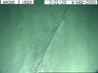
A curious sand wave or ripple on the sea floor, 100 m deep. Dozens of these run in parallel tracks, spaced about 5 m apart. Interpreting this data involves an interesting process of fact construction. The archaeologists, geologists, and techs all look at the sonar traces and make guesses about what the targets may represent. Slowly competing ideas fall by the wayside until one or two interpretations remain. In the case of our long linear feature, the leading interpretation was that it is an ancient road, dating to before the flood. Proponents of this view repeated it to skeptics, pointing out the reasons why it couldn't be anything else. When we finally dunked Li'l Herc on the site, everyone was ready to believe it was a pre-flood road or pathway. My feeling is that this might be an ancient pathway. Or something that we have not considered yet. Or possibly, just a buried pipeline. We just can't say for certain without investigating further. As far as ancient pathways, Fred Hiebert mentioned that parallels can be found throughout the ancient world. Landscape archaeologists have studied similar pathways and linear features in the Americas and Northern Europe. When the ship gets back to port, the data will go to experts for review. All for now, Brendan R/V NORTHERN HORIZON Black Sea Deep Water Archaeology Project 2000
|