|
|
|
|
BLACK SEA 2000 From:
Brendan Foley
Hello once again from off the Turkish coast - I woke up from my two-hour nap today, prompted by the realization that I have less than 48 hours left in this cruise. It seemed silly to try to sleep when I know there are 100 things I could be doing instead. I'll take a few minutes to relate the activities aboard the NORTHERN HORIZON. These cruises tend to end with a bang, not a whimper. We have collected hundreds of hours of video tape, tens of thousands of digital and electronic still images, and scores of gigabytes of sonar data. The trick now is to duplicate, condense, print out, burn to disc, and share as much of this data among the team as possible. Everyone is tired and the seas are absolutely flat calm, but we're all having a hard time sleeping even when we snatch a few hours between watches. The pace is frenetic, but folks are still smiling and laughing. No doubt the success of this cruise helps keep people happy. Last night I worked on the data after my watch ended at 8. About 1 a.m. I decided I better get some sleep, or else my morning watch would be miserable. I grabbed three hours in my bunk, then came back to the control van. Our task for the watch was to finish taking 35 mm still photos of Wreck A for National Geographic Magazine, then transit a short 115 meters to investigate sonar target L1-T35. The sonar trace that led us to Wreck A was beautiful: it's a hard reflective target casting a shadow, with a slight depression tailing away from it. Target L1-T35 was less exciting, a subtle light smudge with no shadow. None of us expected much, but we have to inspect the last few targets in this area before we can put it to bed and move on to the last few things we hope to accomplish.
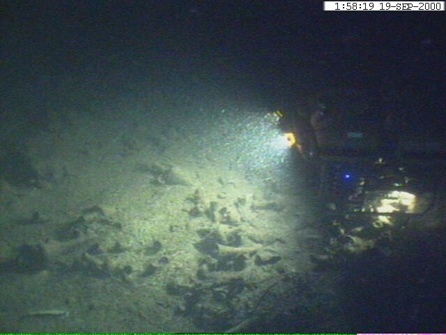
Video capture from Argus vehicle: Li'l Herc ROV over Wreck A, 100 m deep. There was another underwater blizzard last night, with sea snot so thick it was hard to see through it as the vehicle skimmed above the sea floor. About 30 meters out our scanning sonar picked up the target, and WHOI's Craig Elder drove Li'l Herc straight to it. We mounted our 3-chip broadcast quality video camera on Argus yesterday, so we enjoyed incredibly clear (apart from the sea snot) overhead views of Li'l Herc as it swam along. At the edge of the vignette created by the flood lights, dark shapes finally emerged. Jim Newman called out, "Rocks." But a second later a field of amphoras slid into view. Another shipwreck from Sinop! That makes three within a few square kilometers, and two within 115 meters!
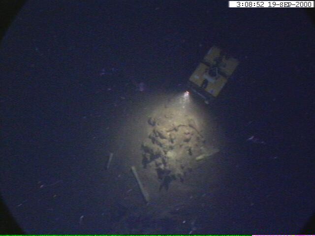
Li'l Herc hovering over Wreck C, 100 m deep. Speculation began to fly instantly. The amphora type on Wreck A and C appears identical. Wreck B's predominant amphora looks the same, plus a couple examples of Byzantine jars. Were these vessels part of an outbound fleet that encountered a disastrous storm? Or, is it just coincidence that two ships ten miles offshore foundered within hailing distance of one another? Unless we can examine the vessels more closely and narrow down the date of their sinkings, we won't ever know for sure. Three late Roman / early Byzantine wrecks and an antediluvian dwelling site in less than two weeks! This cruise has set a standard for discovery that will be very hard to match, and we're not done yet. Tomorrow we plan to recover a few samples from the dwelling site for Carbon-14 dating, and then move back to the anoxic waters. We will investigate some "hard ringers" detected with the DSL-120 side scan sonar during our deep survey a few days ago. Steve Gegg and I picked two of the targets on our watch the other morning, and I hope we get to ground truth them before I have to leave the ship on Thursday. This potentially could be another huge discovery, that "Hollywood wreck" I have been dreaming about since reading Willard Bascom's book, Deep Water, Ancient Ships. This deep water archaeology is a fascinating field because paradoxically to be a specialist in it, one by necessity must be an interdisciplinary generalist. Our survey in the Abyssal Plain three days ago serves as a great example. Before any archaeological analysis can come into the picture, several different engineering disciplines, physical oceanography, geology, physics, chemistry, and computer science must play roles. Bob Ballard selects our survey areas for a bunch of reasons. He's the Chief Scientist, so everything is his call in the end. He has more underwater search and survey experience than anyone else alive, so he has a feeling for where to look. Part of this intuition stems from his background in geology. Dr. Ballard picked a survey region just off Sinop, where the narrow shelf drops precipitously from 200 meters to 2100 meters just a few miles off shore. With geologist Dwight Coleman (from the Institute For Exploration), Dr. Ballard plotted our survey lines. They were looking for flat areas of seafloor with no rock outcropping to hide shipwrecks. Of course, our charts of this area are not terrific and Western scientists have done very little survey work here, so information is sparse. Picking the survey region came down to an educated guess. We dropped the DSL-120 into the water behind Tetanus, and began to collect data. Right off the bat things were different. Steve and Craig had a hard time adjusting the gains on the sonar, as the returns were unlike anything either have seen elsewhere. The physical oceanographic and chemical conditions of the anoxic water do strange things to acoustics. Just like our first dip in anoxia, the sea floor looked black on the sonar record, indicating that the acoustic energy was being absorbed rather than reflected back to the sonar towfish. We cranked the sonar to high power and had to put the gains almost all the way up in order to get the data. A few hours into the survey, Dr. Ballard checked back in with the sonar team. Instead of flat featureless seabed, we were seeing all kinds of weird patterns on the seafloor. The data looked like the dribble castles children make on the beach. Dr. Ballard and Dwight decided that we were seeing evidence of mass wastings, enormous underwater landslides perhaps triggered by seismic activity. These "turbidity currents" carry miles and miles across the seafloor, similar to snow avalanches. Any ancient wrecks predating the landslides would be covered by them, and any following the event would be difficult to detect. We had to find an area devoid of geological background noise. We shifted several miles further to the east of Sinop, but more swirled patterns came back on the sonar. Dr. Ballard decided to switch from the 2100 m deep survey to 300 - 500 m deep. The shelf south east of Sinop (closer to the city of Samsun) gradually slopes out to that depth before it plunges to the Abyssal Plain. No turbidity currents could sweep through that shelf area, since it's above the major precipice. We towed the sonar on the shelf for another round of watches, and that's where we registered almost all of our anoxic targets. Even though we avoided mass wastings at 500 m, we still had some features confusing our shipwreck search. Long ridges of sand waves stand out between about 300 m and 100 m. Their frequency changes from location to location, but they are almost always present. We figured that the ripples around 155 m were remnants from the ancient lake, but the deeper ones had us baffled for a while. Dr. Ballard developed a hypothesis to explain them. Over the years the depth of the anoxic layer rises and falls due to some unexplained mechanism, but the boundary between them persists. The surface water and the anoxic water have different densities, otherwise they would mix freely. It is possible that the interface between them is similar to the air/water interface at the surface. Internal waves might sweep across that anoxic interface, generating sand waves just as surface ocean waves do. Perhaps this is what we are seeing: the signature of internal waves that roll through the Black Sea nearly 1000 feet deep. When we recovered Tetanus and the DSL-120, another surprise awaited us. Rusty old Tetanus benefited from its immersion in the oxygen-free waters. All of the rust on it was gone, and the entire thing was jet black. It looked like it had been painted. The ferrous oxide had been stripped off, and scales of metal fell away when the vehicle swung onto deck. Both Tetanus and the sonar stunk like rotten eggs: the anoxic water is rich in hydrogen sulfide. Here's a project for a chemist and physical oceanographer.
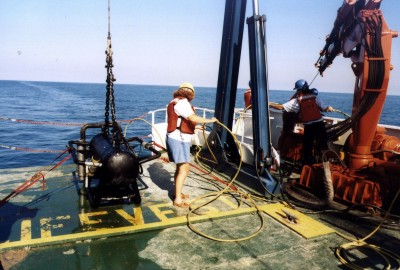
Black Tetanus, after a dunking in the anoxic layer stripped off all the iron oxide. Next to Tetanus, IFE's Cathy Offinger minds Li'l Herc's tether. All this before the sonar targets could even be post processed, analyzed, and prioritized. Maybe there is an ancient shipwreck in the data, but we just won't know until we send Li'l Herc into that poisonous water. Please let that dive happen before I leave the ship! More later, Brendan R/V NORTHERN HORIZON Black Sea Deep Water Archaeology Project 2000
|