
|
Colorado River
The Colorado River is severely threatened by human overuse, environmental issues, and poor river management technique. As an extremely over-apportioned water resource, the water quality of the river is jeopardized by agricultural overdraw, which increases the salinity of the river. Additionally, this overdraw is magnified by climactic variability. With increased temperature and variable precipitation, the amount of snowmelt contributing to the flow of the river can only decrease, which consequently decreases its storage capacity. Invasive species, such as the Tamarisk, or Salt Cedar, threaten the well being of the river's surrounding environment, and also use a great deal more water than native vegetation. While large, hydroelectric dams, such as the Hoover and Glen Canyon Dam, are necessary for power generation, a variety of smaller dams on the tributaries of the river have the potential to cause environmental issues. (See energy section for information regarding dams issues and solutions). Lastly, patchy and ineffective management of the river has led to over apportionment and unfair distribution of the water. These are all issues that must be dealt with to ensure the sustainability of this critical water source. Background InformationColorado River IntroductionThe Colorado River runs 1,397.25 miles from Grand County, Colorado, to the Gulf of California. It is formed by small streams created by an abundance of snowmelt in the Rocky Mountains. Some of its tributaries include the Gunnison, Uncompahgre, San Miguel, Dolores, Green, Escalante, San Juan, and Paria Rivers. The ecology of the river, as well as its flow, varies highly by region (Patrick, 2000,1). The river provides water for over 20 million people, irrigation for 2 million acres of land, 4,000 megawatts of hydroelectric capacity, and over 20 million annual visitor days of recreation (Anderson, 2004, 75). The basin itself is divided into two regions, the Upper Basin and the Lower Basin. The Upper Basin includes Colorado, New Mexico, Utah, and the portion of Wyoming between the Wasatch and Rocky Mountains. The Lower Basin is made up of California, Arizona, and Nevada. These seven states rely heavily on the river for water, as does Mexico. Once in Mexico, the river provides water to irrigate half a million acres of farmland, and municipal and industrial water for 2 million people living in the delta region. The majority of the water, 75%, in the river's average annual flow of 15 million acre feet comes from snow melt in the Rocky Mountains in the Upper Basin. Although the annual flow averages 15 million acre feet, the flow itself is highly variable, having a range of 6 million to 20 million acre feet (Patrick, 2000, 6). The system of reservoirs along the Colorado river can hold approximately four times the annual flow of the river (60 million acre feet), and the largest reservoirs on the river are Lake Powell and Lake Mead, which lie behind the Glen Canyon Dam and Hoover Dam, respectively (Patrick, 2000, 6). 
A map of the Colorado River basin and watershed Retrieved November 27, 2008, from: crc.nv.gov/index.asp?m=maps The river itself is apportioned to the previously mentioned seven states and Mexico as shown in Chart 1: CHART 1
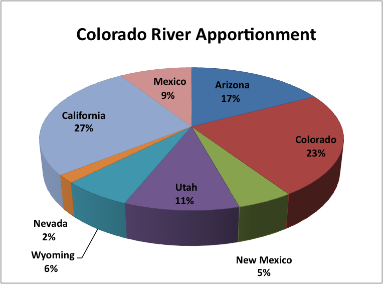
(US Department of the Interior Reclamation Bureau, 1971 - 2005 [USDIRB])
The use of the Colorado River is diagrammed in Chart 2. CHART 2
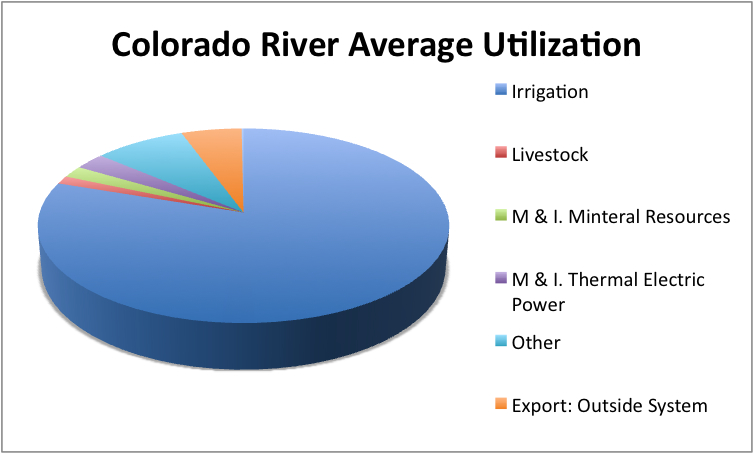
(US Department of the Interior Reclamation Bureau, 1971 - 2005 [USDIRB])
Geology and EcologyThe ecology and geology of the river varies by region. The rock is generally shale and sandstone, with appreciable soluble mineral content. In the event of weathering or irrigation, salts may accumulate on the surface. This salt accumulation can also be due to consumptive use by plants and evaporation. The geology includes bedded and disseminated sodium chloride - halite, calcium sulfate - gypsum, limestone, shale, and granite (Patrick, 2000, 8). The ecosystem around the river is home to 1,400 species of vegetation (Patrick, 2000, 10) - both native and invasive, salamander, five species of toads and frogs (Patrick, 2000, 10), the Grand Canyon Rattlesnake, several species of lizards, 303 avian species - including the bald eagle and peregrine falcon, and beavers (Patrick, 2000, 11). The Grand Canyon is the only river system with appreciable increase, rather than decrease in riparian vegetation and animal populations (Patrick, 2000, 12). Therefore, it is extremely important that these habitats be preserved, and that the use of the river is improved so that human demands do not negatively affect the Colorado River ecosystem. The Law of the River in the USThe Colorado River water in the United States is governed by a variety of legislative documents. The oldest and most important of these is the Colorado River compact, which apportioned the river as seen in the images above. It divided the basin into its Upper and Lower regions, with the dividing line found at Lees Ferry, Arizona, downstream of the Glen Canyon Dam. This compact was signed in 1922 (Anderson, 2004, 78). Following the Colorado River Compact was the Boulder Canyon Project Act (1929). Essentially, this act reinforced the apportionment in the Colorado River Compact and provided for the creation of the Hoover dam and the All American Canal, which brings water to the Imperial Valley in California, the state receiving the majority of Colorado River water. Although this act was passed, the lower states, Arizona, Nevada, and California, could not come to an agreement as to the apportionment of the water in the lower basin (Anderson, 2004, 78). This led to the 1963 Arizona vs. California Supreme Court decision. This decision finalized the distribution of water from the river, and ensured Arizona that its use of the Gila River would not diminish the amount of Colorado River water the state received (Anderson, 2004, 78). Prior to this agreement in the Lower Basin, the Upper Basin states signed the 1948 Upper Colorado River Basin Compact. This compact resulted in the distribution of Colorado River water among the four Upper Basin states, which are Colorado, Wyoming, New Mexico, and Utah. The final apportionment is seen the table above (Anderson, 2004, 79). One of the most recent legislative documents concerning the river is the Interim Surplus Guidelines (2001) (Anderson, 2004, 79). This document allows the Secretary of the Interior to meet the industrial and municipal demands in the Lower Basin, during the time period between 2001 and 2016, when reservoirs were projected to be relatively full. It also allowed for California to reduce its dependence on the Colorado River by 800,000 acre feet annually, since California had been using 5.2 million acre feet, 800,000 over its allotted 4.4 million acre foot annual allocation. These provisions were structured to ensure the protection of the other basin states in times of drought. It also allows Arizona and Nevada the right to use surplus water, in addition to California (Anderson, 2004, 80). The most recent, and final legislative document pertaining to the river is the Quantification Settlement Agreement, signed in 2003. This agreement states that California must adopt measures to reduce its demand to at least the 4.4 million acre foot allocation it is allowed. It also allows the transfer of historical irrigation water from the river, in the Imperial Valley and Palo Verde area to growing municipal and industrial areas in Southern California, whose demands are growing. Additionally, it provided a program to reduce salinity levels in the Salton Sea, and provided $163 million to help reduce this salinity, and also to improve the environment in the Imperial Valley. Lastly, it provided for the lining of the All American Canal, (the water saved from this lining is sold to San Diego) and described the allocations of Colorado River water to individual water user entities in California (Anderson, 2004, 80). DamsThe various tributaries along the river, as well as the river's reservoirs, are controlled by a number of dams. The Glen Canyon Dam is the only major dam on the main stem of the Colorado River above Lees Ferry - in the Upper Basin. The Hoover Dam controls Lake Mead, which is the major reservoir for all of the states found in the Lower Basin. The water behind the Hoover Dam is used for irrigation, municipal, industrial use, power generation, flood control, and recreation. Downstream from the Hoover Dam is Lake Mohave, behind the Davis Dam. This Dam backs water upstream for 67 miles, and is used for some regulation of the releases from the Hoover Dam, meeting treaty requirements from Mexico, and also for power generation at the Davis Power Plant. Further along the river is the Parker Dam, which backs up Lake Havasu for 45 miles. This is the bay from which the Metropolitan Water District of Southern California draws its water, through the Colorado River Aqueduct. It also serves as the bay for pumping for the CAP Havasu Pumping Plant, and pumps water into the Hayden Rhodes Aqueduct. Another dam, the Alamo and its reservoir is used to control floods. The Imperial Dam is the major diversion structure for irrigation in the Imperial Valley and Yuma areas. It also diverts water into the All American Canals. The two dams, Senator Wash and Morelos, assist in delivery of water to Mexico. (Patrick, 2000, 7). US Mexico BorderIntroductionThe US - Mexico border is an arid desert climate, 3141 km long, inhabited by about 10.5 million people. The Colorado River runs along 38km of the border and then runs 100 km through Mexico until it finally discharges into the Gulf of California. These two rivers, as well as their tributaries and other groundwater supplies, are use for traditional irrigated agriculture, industry, and municipal purposes. The International Boundary and Water Commission, United States and Mexico, is a century old organization dedicated to resolving issues concerning water use on the border, as well as allocations of international water sources (Bernal, 2000,1). 180 km north of the border, at the Parker Dam, water is diverted via aqueducts to various states and counties. These aqueducts provide water to the states of Arizona and California, reaching cities such as Los Angeles, San Diego, Tucson, and Phoenix. The population of the areas this water reaches totals 14 million. Further below the Parker Dam is the Imperial Dam, which provides water to California and Arizona to irrigate 277,854 hectares of farmland. In addition to human use, this river provides water for vegetation in native riparian areas, and is an important part of the north-south migratory bird flyway. Mexico diverts water just south of the border, which is used to irrigate 124,000 hectares of agriculture in the Mexicali and San Luis Valleys. An aqueduct also transports water to several cities, providing for a population of about 2 million. These cities include Mexicali, Tecate, Tijuana, and Ensenada (Bernal, 2000, 2). History of IBWCThe International Boundary Commission was first established in 1848 through the treaty of Guadalupe Hidalgo, which established a temporary commission to mark and map the new boundary. Following this, an 1889 convention charged the commission with resolving "differences or questions that may arise on that portion of the frontier between the United States of America and the United States of Mexico where the Rio Grande and the Colorado Rivers form the boundary line ..." (Convention of March 1, 1889). The commission's status was permanently extended in 1900. (Bernal, 2000, 2). The water treaty of 1944 changed the commission's name to the International Boundary and Water Commission. It was established as the organization that the two countries would rely on for the application of water treaties and related boundary issues. It has a Mexican and US section, each headquartered in their respective countries (Bernal, 2000, 3). The 1944 Treaty: Utilization of Waters of the Colorado and Tijuana Rivers and of the Rio Grande: Article 10 provides the following allotment information concerning the Colorado River:
Salinity Concerns in the 1960s and 1970sThe delivery of the excess waters to Mexico mentioned in the section above was hindered in the 1960s with the construction and filling of the Glen Canyon Dam. Mexico expressed some concern that their ability to receive excess water would be diminished by the dams on the US section of the Colorado River. In addition to this reduction, highly saline drainage was being introduced to the river very close to the point at which it enters Mexico, which led to a salinity issue. This drainage was coming from a district in Arizona, and in 1961 Mexico deemed its water unusable due to the excess salinity (Bernal, 2000, 4). In response to this issue, the US constructed a concrete diversion channel that would bypass the drainage area, and prevent highly saline water from going to Mexico. The US also regulated the pumping of the drainage area, and this agreement was carried out until 1972. The salinity of the water entering Mexico was reduced (Bernal, 2000, 5). IBWC Minute 242Minute 242, Permanent and Definitive Solution to the International Problem of the Salinity of the Colorado River, was signed in 1973 by representatives of the IBWC, and had the following important provisions:
Conveyance CapacityIn 1993 a flood of the Gila River led to a large amount of sediment entering the Colorado River. That year the amount of water delivered to Mexico greatly exceeded the norm. With more sediment in the river, it was estimated that the amount of water delivered to Mexico could be reduced by 300 cubic meters per second. This led to some concern in Mexico as to the amount of water they would receive and be able to use (Bernal, 2000, 5). Minute 291 was signed in 1994 to provide a solution to this issue, and resulted in:
Colorado River International Task ForceThis task force was established following the issues concerning conveyance capacity. It was established in 1995 and its objectives are to study conveyance capacity, use and purity of the river, and special technical issues. These technical matters include salinity control, channel excavation, bank protection, and rectification. Beginning in 1995 this task force studied salinity of the water entering Mexico, and it was determined that water entering Mexico at the Southerly International Boundary was very saline and merited discussion. During this study Mexico informed that US that it mixes the saline water that is delivered with groundwater and water from other sources. The task force also investigated the inefficiency of Mexican irrigation. They provided a variety of suggestions to help improve the water quality. These included installing variable speed pumps at the delivery stations at the border and replacing high salinity drainage flows with less saline groundwater. Some longer term solutions to this problem determined by the task force include a joint US Mexico effort to clear silt around the Morelos Dam. The US Bureau of Reclamation would facilitate this removal for 1372 miles of the international reach of the Colorado River. In late 1999 the Bureau of Reclamation began work to remove 1.9 million cubic meters of silt in this area, at a cost of $12 million. The US is also preparing for environmental studies to improve the carrying capacity and preservation of the river as an international boundary (Bernal, 2000, 7). Group on the Mexican DeltaIn addition to the efforts to improve conveyance, silt, and long term solutions, a fourth group was created by the IBWC to work on the Mexican delta. They were to carry out a baseline study of the water and the natural resource conditions in the delta area. A variety of environmental organizations have expressed interest in the study of this region (Bernal, 2000, 8). Financial AgreementsThe financial arrangements of the IBWC have been made by task, rather than predetermined. Each task has its individual financial agreements, which results in a variety of funding methods depending on the task. The division of costs is on a case by case basis (Bernal, 2000, 9). Colorado River Water IssuesOverdraw and Negative EffectsSome statistics of the river are pictured in Chart 3. CHART 3
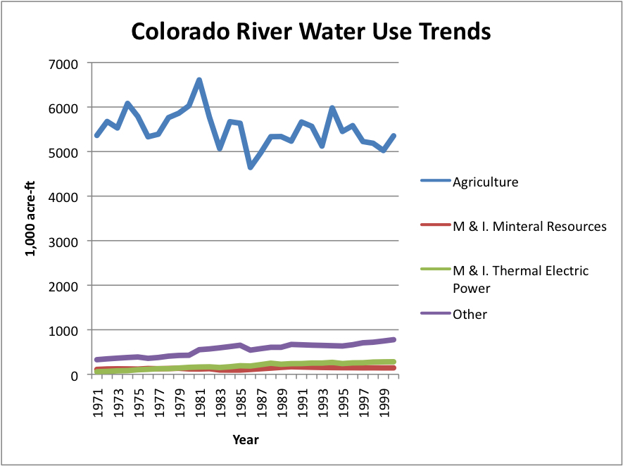
(US Department of the Interior Reclamation Bureau, 1971 - 2005 [USDIRB])
Increased consumption by agriculture, as well as municipal and industrial users, severely threatens the sustainability of the Colorado River through increased demand and decreased supply. From the figures above, it can be seen that the largest consumptive user of the river water is agriculture - consuming, on average, 5,507,780 acre feet annually. Municipal and industrial thermoelectric power consumes 1,872,633 acre feet annually on average, and mineral resources consumes 132,000 annually on average. Other municipal and industrial uses account for 555,700 acre feet of consumptive use. Trends show that consumption due to thermoelectric power, mineral resources, and other municipal and industrial uses has been rising steadily during the last few decades. This increase in consumption, coupled with extremely high use by agriculture, leads to an unsustainable water supply, with the demand greater than the available water (US Department of the Interior Reclamation Bureau, 1971 - 2005 [USDIRB]). Not only is the flow threatened by climate change and overconsumption, but the reserves, especially those in Lake Mead and Lake Powell, are being significantly depleted. It took nineteen years to fill Lake Mead to a level of 24 million acre feet in 1998, and between then and 2007, the lake's level had decreased by 54%, leaving only 11.5 million acre feet of water behind the Hoover Dam (Colorado River District, 2007, 13 [CRD]). In fact, research at the Scripps Institution of Oceanography indicates that there is a 50% chance that Lake Mead will by completely dry by the year 2021. This result is if current water use is not curtailed, in addition to the negative effects of climate change. It is also predicted that by 2017 hydroelectric power generation in the Hoover Dam will be impossible due to the low water levels in Lake Mead. (Scripps Institute of Oceanography, 2008 [SIO]). Lake Powell, behind the Glen Canyon Dam, is experiencing a similar situation. It took seventeen years to fill Lake Powell to its full capacity of 27 million acre feet, and in just six years, between 1999 and 2005, the level of the lake had been reduced by 60% (CRD, 2007,13). This water use is clearly unsustainable, and the shortage in this lake negatively affects Colorado, Utah, Wyoming, and New Mexico (the Upper Basin states) directly and also the Lower Basin. The Glen Canyon Dam can only continue to generate hydroelectric power as long as there is water behind it, and so the reduction in the level of Lake Powell has the potential to negatively effect a vast population of the American west. 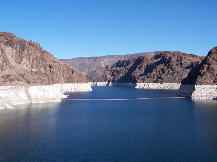
Lake Mead:This picture of Lake Mead dramatically illustrates the depletion of the reservoir. Retrieved November 27, 2008 from: eapsweb.mit.edu/.../Day%202/day%20two.html Climate Change and Decreased Flow and StorageGlobal warming has had its effect on the American Southwest, and thus the Colorado River basin. With increases in temperature, the flow and storage of the river is projected to decrease. While this is in part a natural occurrence, it cannot be compensated for with the current overdraw described above. Climate is an unavoidable factor in the water shortage the basin is experiencing, and therefore it is necessary to understand its Negative effects in order to conserve water to counter them. The Upper Basin receives heavy precipitation in the form of snow, and provides 75% of the river's flow, which totals 15 million acre feet. The Lower basin lies only a few feet above sea level, and has a precipitation rate of 1.5 to 8 inches annually (Patrick, 2000, 6). The rain falling in this region does not contribute significantly to the flow of the river, since the vast majority of it is consumed by plants or evaporated. Changes in temperature have the potential to seriously deplete the amount of available water in the Colorado River. According to hydroclimate modeling studies, for a 2 degree Celsius increase in temperature in the basin region, neglecting any change in precipitation, the streamflow of the river reduces by 4 - 12%. Furthermore, with a 4 degree Celsius increase, the streamflow reduces by 9 - 21% (Committee on the Scientific Bases of Colorado RIver Basin Water Mangagement, 2007, 89 [CSBCRBWM]). Additionally, with increased temperature, runoff is projected to decrease. According to a 2004 study by Christensen, reductions in runoff, coupled with a 1 to 6% reduction in precipitation, which is highly variable, could lead to a 4 to 18% reduction in streamflow over the next 50 years. The US Bureau of reclamation predicts that a 20% reduction in runoff would lead to a 60 to 70% decrease in storage and a 15 to 20% increase in salinity at the US Mexico border. Christensen predicts a 40% decrease in storage with an 18% decrease in runoff ([CSBCRBWM], 91). Although these numbers do vary, it is clear that climate change has the potential to greatly reduce the amount of available Colorado River water, which is a vital water supply in the American Southwest, as well as in Mexico. Salinity and Water QualityA major issue concerning the water quality of the Colorado River is salinity. Salinity seriously diminishes the water quality of the river, and can even result in completely unusable water. Each year, 9 million tons of salt are carried down the Colorado, caused by both natural and manmade sources. The concentration varies, and the salinity at any point in the river is influenced directly by reservoir storage, water resource, development, salinity control, climatic conditions, and natural runoff. There are a variety of natural sources of salinity, which effect the water quality of the river. One of these is saline springs, which contribute the largest overall natural share of salts to the river. Runoff due to snowmelt and thunderstorms also have the potential to increase the river's salinity depending on the storm period and any dissolved solids in the water (Patrick, 2000, 216). While natural salinity contributions are essentially unavoidable and need to simply be compensated for, manmade contributions to the salinity of the Colorado River are unnecessary and can be remedied. The first manmade contribution to salinity is due to groundwater. This occurs due to leaching of coal spoil materials, oil and gas production, consumptive use of high quality water, and mine de-watering. All of these are practices that could be prevented with more caution on part of the people living in areas around crucial aquifers. Another human-made source of salinity is found in the municipal and industrial use of water, which accounts for 4% of the salinity in the river, and is projected to increase significantly (by 133,000 tons of salt) by the year 2010. Overuse leads to withdrawal of water and discharge of more salts than necessary. Domestic level changes are necessary to improve this situation. However, greater than all of these sources is the salinity created by agricultural water users. As the single largest source of increased salinity, agriculture accounts for 37% of the increased salinity in the Upper Basin (Patrick, 2000, 19). The increased salinity created by agriculture does not only diminish the water quality of the river, but also has negative effects on the farming. Due to more saline irrigation water, the crops that can be grown are limited, yields are reduced, and the salinity in root zones is increased. In addition to this, the more saline the water is upon entering Mexico, the more money will have to be spent on maintaining and operating the Yuma desalination plant (Patrick, 2000, 19). The farther south on the river one travels, the more significant these negative effects will become, since the majority of the river's flow comes from the mountains in the Upper Basin. In order to compensate for climactic changes that cannot be prevented, and to improve the sustainability of the water source, the manmade contributions to the salinity of the Colorado river must be reduced. Tamarisk as an Invasive SpeciesAn environmental issue regarding the Colorado River is the invasive species, Tamarisk. Tamarisk not only crowds out natural riparian vegetation, but also consumes an alarming amount of water. To effectively conserve as much water in the river as possible, it is necessary to combat this invasive species. Also known as salt cedar, these plants were imported in the 1850s as an ornamental plant and also as a method of erosion control. While their roots run deep, which prevents erosion; they also consume an unsustainable amount of water. Tamarisk covers 50,000 acre of the Colorado River basin area, and consumes 170,000 acre feet more water annually than the native vegetation on the basin. Additionally, these plants crowd out native riparian vegetation (CSBCRBWM, 2007, 122). More broadly, these shrubs cover approximately 1 million acres of the west, with its range stretching from northern Mexico to Montana, and Kansas to the Pacific, and consume much more water than the native vegetation (Nijhuis, 2007). In drier areas, especially along riverbeds, the amount of water consumed by tamarisk is much greater than its neighbors than in wet areas around streams (Nijhuis, 2007). In addition to water depletion, the animals living in areas occupied by these shrubs are generally fewer in number and type, and are less healthy than in areas unoccupied by tamarisk. It has also been thought by researchers that the density of the growth increases the occurrence of fires in riverbed areas, and it grows back very quickly even after burning (Nijhuis, 2007). Although the depletion of the river due to tamarisk is small compared to that of agriculture, municipal, and industry, during the current water crisis it is important that the species be removed in order to effectively conserve Colorado River water, and to restore the natural ecosystem of the basin. Law and Management of the RiverThe most major issue concerning the law and management of the river entails the approach to management. Patchy management of the river has led to a lack of inflow, and consequently, environmental issues in the surrounding ecosystem. Management issues are to blame. Currently, there is no overarching management of the entire river basin. This is a problem. It has been shown that a scattered, fragmented approach to river management is not effective. Evidence for this is seen most extremely in the unfair allotment of the river's resources and the lack of attention to water quality and environmental issues. A comprehensive approach to the management of the river is crucial if any conservation of resources or environmental restoration is to successfully occur. Currently, there is no federal mandate that would set the basin states' required water contributions toward restoring the ecosystem in the delta (Morrison, Postel, &. Gleik,1996, 55). Additionally, many aspects of the river, including fishery protection and ecological priorities, are not recognized in the river policy (Morrison, Postel, &. Gleik,1996, 56). Additionally, the river itself is over apportioned and thus its annual flow cannot be maintained, nor can the levels of the reservoirs it supplies. Since the mid 1990s, environmental interest groups have begun implementing legislative documents such as the Endangered Species acts to modify management of the river. Recreational users have also stated that they wish their interests be represented. However, no concrete rights to the Colorado River have been given to these groups under the current management. While laws like the Endangered Species Act (ESA) and the National Environmental Policy Act (NEPA) have some influence on the management of the river, nothing comprehensive has been formulated. The 1922 Colorado River Compact apportioned the river based on the assumption that there would be a 3 million acre foot cushion - they believed the annual flow of the river to be 18 million acre feet, when in reality it was closer to 15 or 16 million acre feet. Due to this assumed excess flow, no inflow was determined necessary to maintain the healthy state of the ecosystem. Despite this over-apportionment and lack of provision for the ecosystem, all following legislation has been based on the flawed Colorado River Compact of 1922. In order to combat the degradation of the ecosystem created by over-apportionment of the river, it is necessary to develop additional sources of instream flow, and also to reduce the dependence of these states on the river's water (Morrison, Postel, &. Gleik,1996, 66). For Information about issues regarding Dams, see energy section. |

|