Climate Change
Climate change is undoubtedly threatening the water availability and quality in the American Southwest. The global dynamics are becoming unable to keep the temperature constant because of climate change. Over the last 90 years, the temperature in the Southwest has already increased by 2 - 3°F. In this century, it is projected to keep increasing by approximately 5°F - twice that of the last century. Some models even predict a change of as high as 11°F. Increasing temperatures have reduced the snowpack on western mountains, which are the primary water sources of the Southwest, by 15 - 30% since 1950. The Colorado River Basin low-elevation snowpack (below 2500 m) may halve in 2100, with a possibility of total disappearance of snow below 600 m. Extreme weather such as floods and droughts occur more frequently and with greater intensity throughout the region.
While the amount of water available is reducing, the population growth rates in the Southwest are among the highest in the United States. The population increase will put more pressure on the water resources that are already at their limit. In the past 20 years, the rapid depletion of water in the Southwest has been remarkable. Lake Mead of the Hoover Dam, for example, took 19 years in an unusually wet period since 1964 to fill to 24 million acre-feet. However, in 2007, only 12.5 million acre-feet remained in the lake. Lake Mead is the biggest reservoir in the Southwest that supplies water for 22 million people. Las Vegas, too, receives 90% of water from the lake. It is questionable whether in the future there will be enough water to generate electricity in the Hoover Dam which currently supplies enough energy for 1.3 million people. (Bureau of Reclamation, 2006)
The reduction of water has been observed not only in Lake Mead, but also throughout the river. The average annual runoff before mid 21st century is projected to reduce by around 20%. By that time, the runoff will be able to supply only 60 - 75% of the water stated in the Colorado River Compact, meaning the demands will exceed the supply in about two decades. Less water will inevitably lead to less agriculture and electricity produced. It is thus crucial to address the climate change problem in our Mission since it is greatly reducing the water availability in the Southwest.
Preface
Over the past century, exploitation of the Colorado River and groundwater resources have allowed the American Southwest to grow enormously; the population has multiplied by 15-times in only 90 years. (Wright and Chourre, 2003) The seven Colorado Basin States (AZ, CA, CO, NM, NV, UT and WY) currently use 21.1% of the water withdrawn from both groundwater and surface water in the whole nation (85,970 out of 408,000 million gallons per day), with California alone using 12.5% of the nation's total water withdrawals (51,200 million gallons per day). (Hutson et al., 2004)
The regulations governing distribution of water from the Colorado River have been based on the 1922 Colorado River Compact. However, we now know that the compact was based on the water availability during an abnormally wet period - between 1900 and 1925 - the wettest years in four centuries. (Bates et al., 2008) This has led to extravagant allocations that have not been reflecting the actual resources available. For example, the Compact agrees to allocate 15 million acre-feet of the river per year, even though the actual flow can be as low as 6 million acre-feet to the maximum of 20 million acre-feet (Patrick, 2000).
There is little question that we can document progressive changes of climate in the western U.S. caused by both natural and anthropogenic processes. There will almost certainly be more and more pressure on water from the Colorado River even though there continues to be much less water than amount available during the years that the compact was based on. Climate change will affect both water availability and water quality (Houghton, 2001). Higher mean temperatures will increase the rate of evapotranspiration and exacerbate droughts in some regions, while it may increase precipitation in other areas. Higher mean winter temperatures will reduce the amount of snowpack which is a major source of run-off that supplies rivers such as the Colorado. An earlier spring will melt the winter snow faster, further reducing the amount of available water for the summer and fall. Rising sea-levels caused by the melting icecaps can cause seawater intrusion into coastal aquifers, making them not potable. Moreover, increased temperature stimulates the growth of microorganisms, which deteriorate the water quality.
Why Should We Care?
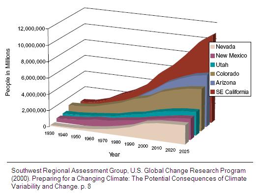
The American Southwest is much more water limited than other parts of the U.S. (Lettenmaier et al., 2008) It is growing fast; the populations in Nevada and Arizona are projected to more than double while California's and Colorado's will increase by nearly 40% by 2030 (U.S. Census Bureau, 2004). The growth rates of AZ, CA, CO, NV, NM and UT (six of the seven Colorado River Basin States) were among the highest in the country in the last decade. Currently, the 55 million people in the Southwest region, equal to 18% of the national population (U.S. Census Bureau, 2004), use 21.1% of national water withdrawal for domestic uses, agriculture, industry, and energy generation (Hutson et al., 2004).
The growing population will put more pressure on supplies of food, water and energy. Projections of warming in the west are our concern because it could lead to a reduction in the amount of available water, which will then reduce food production and even hydroelectric power generation. Secondary effects of rising temperatures, even without the population growth, include higher per capita consumption and increased demand of electricity for air conditioning. As base level flows in rivers decrease, we will see increased problems with salinity and agricultural contaminants. When projections for demand of water are made, some predict that the increasing water demands due to population growth will exceed the available supply by 2030 (Bates et al., 2008).
In this section, we will describe how Climate Change affects the population in different ways, with a focus on the American Southwest. We address the issue of climate change since it is a significant factor of water quality and availability.
Direct Impacts of Climate Change
The main impacts of concern are temperature, precipitation and run-off.
Temperature
The surface of the earth acquires most of its energy from the sun in forms of high-energy radiation and excess heat is reflected back off the earth's surface. However, certain types of gases, specifically green house gases, prevent this excess heat from escaping the earth's atmosphere. This traps more heat inside the planet, and keeping the surface temperature of the planet remarkably constant.
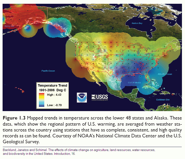
Over the past thirty years, Colorado's annual average temperature alone has increased by 2°F and it will continue to increase an additional 2.5°F by 2025 and 4°F by 2050 (Ray et al., 2008). Since 1920, California's annual minimum temperature has risen by more than 2.5°F and the annual maximum temperature has increased by nearly 1°F (Moser and Franco, 2008). In general, temperature records show that the American southwest region has had a trend of 2 to 3°F increase in annual temperature (U.S. Global Change Research Program, 2000), with a projection of a 3.6 to 5.2°F increase in the late twenty-first century (Christensen et al., 2007) (Field et al., 2007). Many studies also agree that by 2050, there will be a 4°F (coastal) or 5°F (inland) increase in temperature throughout the Western USA, (Ray et al., 2008) while the Canadian Model projects as high as an 8 to 11°F increase in CO, NM, and portions of AZ, CA, NV and UT in this century. (U.S. Global Change Research Program, 2000)
Increased temperature causes a wide range of problems associated with water availability such as increased evaporation, decreased precipitation, seasonal shifts, extreme climatic hazards, such as droughts, biodiversity imbalance and loss in food production.
Precipitation and Seasonal Shifts
Precipitation in the Southwest is approximately bimodal; that is, it has two rainfall maxima. One maximum is in summer during the monsoon season caused by the Gulf of California and the Gulf of Mexico. The other maximum is in winter caused by frontal systems (the transition-zone boundaries between two air masses with different properties) generated in eastern Pacific Ocean (U.S. Global Change Research Program, 2000). Even though it rains more in summer, the high temperatures increase evapotranspiration rates, which decrease water resources. On the contrary, cooler temperatures in winter keep the water from evaporating, which contributes to surface and groundwater recharge (U.S. Global Change Research Program, 2000).
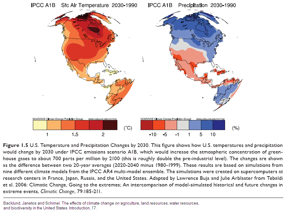
In the last century, some parts of the Southwest, i.e. southern NV, UT, NM and central AZ, experienced reduced precipitation even though the northern and southern areas of AZ and CA received increased precipitation (U.S. Global Change Research Program, 2000). Many studies agree that, by 2050, the overall precipitation in the Southwest will reduce within a 0% to 10% range (Ray et al., 2008), and a 0% to 6% range in the Colorado River Basin (Ray et al., 2008). Even though the change in total amount of precipitation may not seem significant, the shift in precipitation types can still endanger water resources. In other words, global warming seems to increase rainfall and decreases snowfall without significantly changing the total precipitation (Britt, 2005). Annual precipitation of rain has increased by 74% in the western U.S. from 1949 to 2004 (Field et al., 2007). More generally, projected climate change will cause "warmer and wetter" weather in the Southwest, although the precipitation trends are less predictable as stated above (U.S. Global Change Research Program, 2000).

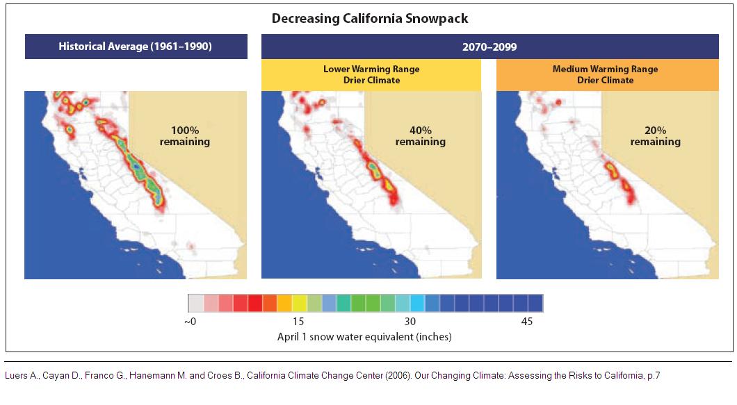
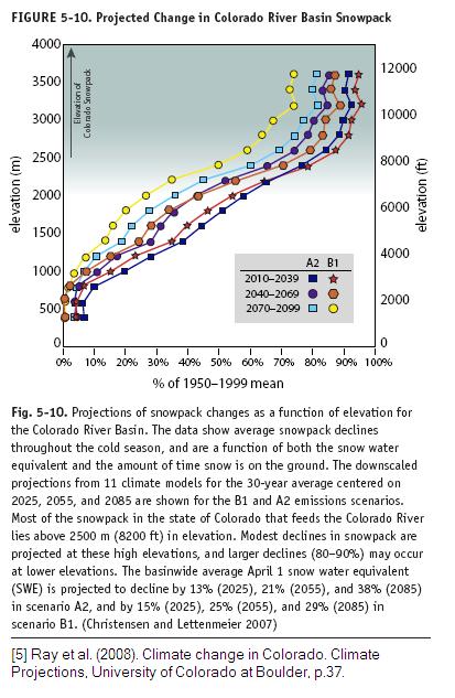
A wetter climate, or more rainfall, is not as manageable as precipitation in the form of snowfall. Current water management techniques are designed to capture the water supplied by gradual snowmelt from April to July and release it to the community during dry seasons. Snowpack loss has thus become a central issue in climate change because it can put the water supply at risk. Since temperature decreases as altitude increases, the decreased snow runoff can be most clearly observed at lower elevations where there is greater sensitivity to increased temperatures. Higher elevations are experiencing a rapid change and the lower elevations are experiencing decreased levels of snowpack. Many studies indicate that since 1950, snow-water-equivalence in the western mountains of the US has declined by 15% to 30% (Field et al., 2007). Snowpack loss in the Sierra Nevada Mountains, which has decreased by about 10% in the last decade, and snowpack loss in the Colorado River Basin are likely to put 41% of Southern California's water supply at risk (National Science and Technology Council, 2008) (The Resources Agency, 2008) (Field et al., 2007). At the current rate, by 2070, 30 - 95% of low-elevation snowfall, below 2500 m or 8200 ft, in Colorado will be lost relative to the 1950 - 1999 mean, with a possibility of total disappearance of snow below 600 m or 2000 ft in 2100 (Ray et al., 2008).
The earth's climate zones can be roughly divided by latitudes into the hot equatorial zones, the cool temperate zones and the cold polar zones. However, since the1960s, it has become evident that winter arrives approximately a week later in the higher latitudes than its usual arrival due to warming weather, indicating that the warm climatic zone is shifting northwards (World Resources Institute). For example, in Colorado, the winter and spring storms are becoming wetter, and spring arrives two weeks earlier than it used to. As a result, Colorado is experiencing a shift towards mid-winter precipitation and a decrease in late spring precipitation (Ray et al., 2008).
The two main impacts of a gradual warming in western North America on precipitation are (1) a higher rain/snow ratio and (2) earlier snowmelt. The Southwest relies on the melting of winter snowpack in providing slow release of water during the drier months of the year (Knowles et al., 2007). Thus, a decrease in snowfall and an earlier snowmelt can endanger the water supplies during the dry season. On the other hand, the increased rainfall and early snowmelt raise the possibilities of exceeding the river bankfull discharge and floods (Vigran, 2008) (The Resources Agency, 2008).
Streamflow and Runoff
As temperature rises due to climate change, snow melts earlier in the spring; the peak streamflows have been reported to occur around a week earlier in the year (Ray et al., 2008). An earlier snowmelt means that there would be less water available during the dry seasons when most snow has already melted, in addition to the increased evapotranspiration caused by rising temperatures (Ray et al., 2008) (U.S. Global Change Research Program, 2000). One study claims that for every 1.8°F increase in temperature, global total runoff can rise by 4% (Bates et al., 2008). While annual runoff will increase in the Eastern U.S., it is projected to decrease in the Western U.S. (Ray et al., 2008) (Bates et al., 2008).
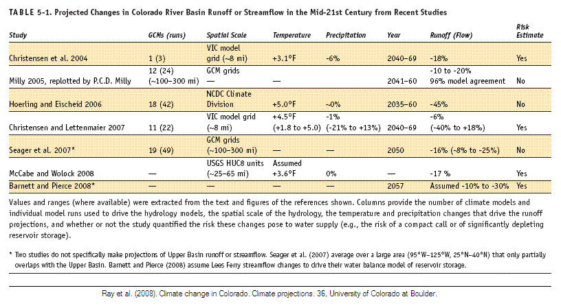
By 2060, there will be around a 30% reduction in annual runoff in AZ and more than a 40% decrease in annual runoff in UT, CO and CA (Milly, 2005) (Ray et al., 2008). More generally, many models predict that by the mid 21st century, there will be a 5 - 25% decrease in runoff throughout the American Southwest. (Ray et al., 2008) Shockingly, 23 out of 24 models show more than a 10 to 25% runoff decrease for the Upper Colorado state, whose runoff actually supplies most water in the Colorado River Basin (Lettenmaier et al., 2008). By 2025, only 60 to 75% of the 1922 Colorado River Compact will be able to be met (Christensen et al., 2004) (Bates et al., 2008). On the one hand, climate change makes the dry seasons even drier. On the other hand, climate change can increase the possibility of flooding by increasing rainfall and snowmelt runoff in some regions and even during rainy seasons (Bates et al., 2008).
Runoff is naturally managed by vegetation cover. As rain falls, it is firstly intercepted by leaves, flows through stems and then infiltrates the soil. All these processes happen slowly over a matter of days. Temperature increases due to climate change may reduce vegetation cover because more wildfires will occur and there will not be enough water to support the existing species of vegetation. In this situation we will have a reduced lag between peak of precipitation and peak run-off as the buffering capacity of the watersheds are reduced. Human factors, such as urbanization and the paving of land surfaces also serve to reduce the lag time between peak precipitation and peak run-off leading to flash-floods. Furthermore, overland flow without vegetation cover may lead to enhanced leaching and transport of contaminants and chemicals in the soil to water resources, jeopardizing the quality of drinking water (The Resources Agency, 2008).
Implications of Climate Change
In general, global warming caused by humans leads to more extreme weather with floods and droughts. This creates a much less reliable water supply, which in turn endangers the water quality, power generation, and agricultural production. Also, loss of vegetation cover raises the issues of desertification and soil erosion.
Floods
Rivers have a limited capacity, called the bankfull discharge. Increased snowmelt and precipitation in forms of rain due to climate change contribute to the overland flow in the river, thus increasing the likelihood of exceeding the river bankfull discharge and creating floods. The flood intervals are becoming less reliable since floods occur more frequently than they used to. The changing flood patterns can be problematic to hazard management programs and land-use planning. The flood insurance programs such as FEMA (Federal Emergency Management Agency) and the land-use planners often use historical flood recurrence intervals to make decisions on their insurance and city construction plans, but as the historical data become less reliable, more people become prone to being affected by floods.
It is stated that, in Santa Cruz, a 12-inch increase in sea level can shorten the 100-year interval into ten years (Leurs et al., 2006). Out of all of the natural disasters, floods affect the most people (Bates et al., 2008). On a global scale, there were ten times more great floods during the decade from 1996 to 2005 than in any of the three decades between 1950 and 1980, (Bates et al., 2008) indicating that the recent climate change is contributing to the shorter flood recurrence.
Changing water competency (which indicates the power of flowing water) due to rapid overland flow can change erosion patterns while higher temperatures themselves stimulate more erosion. River features like shape, depth, and sedimentation patterns are altered, making river management more difficult. If there is more silt deposition, bankfull discharge will be reduced, making them easier to flood in the future. High sedimentation can overload and destroy dams. The current dam technology is designed to cope with slow running water and is unable to capture flood water. Flooding washes chemicals, heavy metals and nutrients into the water (National Science and Technology Council, 2008); the quality of the floodwater becomes bad and not suitable for drinking (The Resources Agency, 2008). Decreased water quality can poison people with water-borne diseases. All in all, increased temperatures will lead to less reliable supplies of water with much greater variability characterized by sudden flood events rather than predictable flow.
Droughts
Allocations of Colorado River water and planning for its distribution, including reservoir construction, irrigation projects, and groundwater withdrawal, occurred mostly during the wettest period of the century (1905 to1925) (Bates et al., 2008). Most parts of the Colorado River Basin are actually semi-arid; only 15% of the area supplies 85% of the total flow (Bates et al., 2008). In recent years, climate change has noticeably increased the intensity and the frequency of droughts and decreased the availability of surface water, forcing people to withdraw more groundwater.
Droughts put more threats on forests due to the increased likelihood of fires. They can completely destroy current vegetation, making the area more prone to floods and erosions which subsequently worsen water quality. Livestock that are dependent on the non-irrigated lands will be seriously affected by losing many food resources (The Resources Agency, 2008). Since 1990, on average, 14% of the Colorado River Basin areas experienced severe droughts annually. Since 1999, 40% of the Western USA was under severe drought as shown by the lowest record in Colorado River streamflow (Bates et al., 2008). It is predicted that, by 2020 or 2030, the discharge may not meet the current increasing demands for the water (Bates et al., 2008). Droughts directly cut down the water supplies going to the people. This is very similar to discussion above about flashy discharge.
Water Quality
Water quality usually refers to the chemical and biological inputs to water (Lettenmaier et al., 2008). These inputs are obtained during the flow paths of the water into the river. Climate change in higher latitudes causes more rainfall and less snowfall, increasing the possibility of overland flow and flooding, allowing soil erosion, and bringing more contaminants into the river (National Science and Technology Council, 2008) (Lettenmaier et al., 2008). It is reported that 68% of the 548 outbreaks of waterborne diseases between 1948 and 1994 were associated with the 80% increase in precipitation intensity, which substantially washed pollutants into the surface waters used by people (Curriero et al., 2001) (Lettenmaier et al., 2008).
Not only wetter climates but also drier climates can exacerbate water quality. Increased droughts reduce the flushing rate - the frequency that the storage is refilled with new water (Murdoch et al., 2000). Chemicals, nutrients and microorganisms in the storage can accumulate over a long period of time, and become very concentrated because there is no water for dilution (Lettenmaier et al., 2008), endangering the ecosystem which cannot cope with such polluted water. At the same time, reduced runoff brings less sediment load to other water storage areas, leaving the water very transparent and allowing microorganisms at depth to grow and deplete oxygen in deeper parts of the water (Schindler et al., 1996) (Lettenmaier et al., 2008).
An increase in temperature, together with an increase in nutrient levels increases in water storage, enhances biological activities in water and stimulates an excessive growth of microorganisms (Lettenmaier et al., 2008) (Lettenmaier et al., 2008). Blue-green algae, for example, thrive under global warming conditions (Paul). This process of eutrophication is very oxygen demanding and it reduces dissolved oxygen (DO) in water, making it difficult for other organisms such as fish to live (The Resources Agency, 2008). Higher temperatures will also increase the habitat suitable for warm-water fish, but will reduce the suitable habitats for cold-water fish by 45% and for cool-water fish by 30% (Lettenmaier et al., 2008). Algae may build up a few feet thick on the water's surface, preventing water from exchanging gas and getting the necessary sunlight. Natural photosynthetic producers (plants) subsequently die off and the eutrophicated water becomes unsuitable for life. Such cyanobacteria are dangerous to a human's health (Science Daily) in addition to endangering aquatic lives.
Loss in Power Generation
Hydroelectric power is the United States' largest renewable source of electricity (National Science and Technology Council, 2008). Water flowing down from high elevations is used to spin turbines located in powerhouses and generate electricity. It constitutes 11.4% of all energy production in the seven Colorado River Basin states, with 22.2% produced in California alone (Energy Information Administration, 2006).
Climate change can lower reservoir levels, which are essential for the production of electricity. Changes in streamflow are magnified through multiple dams in a river basin, and it is estimated that the change in energy production can be three times more severe than the change in streamflow in the Colorado River (Nash and Gleick, 1993) (National Science and Technology Council, 2008). In California, only a 3.1 to 4.4°C increase in temperature together with a 10 to 20% decrease in precipitation may reduce the hydroelectric power generation by 30% (equal to 6% of total state energy) (National Science and Technology Council, 2008) (Leurs et al., 2006).
Considering such a big proportion of hydroelectric power in the American Southwest, reduction in streamflow can put energy availability at risk. The warming climate will likely make people use more electricity for air conditioning - a 20% increase in electricity demand is expected for the current population if temperature rises by 8 - 10.5°F (this estimate has not taken the population growth into account) (Leurs et al., 2006).
Case studies of Glen Canyon Dam and Hoover Dam can illustrate the severity of the recent changes in reservoir levels. Lake Powell, the reservoir of the Glen Canyon Dam, took 17 years to fill up to its full capacity of 27 million acre-feet. However, from 1999 to 2005, 66% of the water was depleted. Similarly, Lake Mead, the reservoir of the Hoover Dam, had taken 19 years from 1964 to fill. In 1998, there was 24 million acre-feet of water. However, during the last decade, 11.5 million, nearly half, of the storage in Lake Mead was depleted. (Colorado River District, 2007)
Agriculture
As climate continues to change it will have a large impact the agriculture industry, especially in the Southwestern United States. Crops are highly sensitive to temperature thus the change in temperature, which is occurring and that is expected to continue changing, will have a direct effect on the crop yield (Adams, 1990). Although the average annual temperature difference in climate is on the scale of one or two degrees Celsius the difference in temperature during smaller periods of time compared to historical data is much more drastic (Adams, 1990). Since there is also an increase in carbon dioxide that plants require for photosynthesis the crops are slightly benefited, however, according to models of temperature change this does not hold true for crops that depend on rainfall only for most which are irrigated (Adams, 1990). This could present a problem since our water supplies are diminishing at an alarming rate and less water is available for irrigation.
In order to present a better assessment of the likely effects of climate change it is necessary to look at California, one of the states in the Southwestern region that would be deeply affected by this change in regards to agriculture. A change in climate patterns in California, that tends to have dry weather, would affect the amount of water required for irrigation (Schlenker, 2007). Another problem that would arise is the storage of water. The snow which falls in California and remains as snowpacks serves as a storing device of water for the warmer months when there is less water and more water is required for irrigation (Schlenker, 2007). The increase in temperature in water will lead to higher run off in earlier months ultimately leaving the agricultural sector with less water. Decline in access to water could lead to lower quality of soil causing more detrimental effects on the agricultural sector (Schlenker, 2007).
Rising Sea-Level
Substantial melting of the ice caps causes the sea level to rise. By 2100, a 7 to 55 inch rise in sea level may occur along the Californian coasts. Coastal management, such as the delta levees, will need to be modified, as they have a tendency to fail when sea levels rise. Storm surges are projected to increase in intensity, making the coast more vulnerable to floods. Salt water intrudes the freshwater ecosystems and can eliminate the native habitants. (The Resources Agency, 2008)
|